Enable Location

We need your location to show you interesting places around you

Discover nearby places

Find interesting locations and hidden gems around you

Precise directions

Get accurate directions and distances to places

Your location is never shared with other users. It's only used when you tap the location button.

Cametá

Log in to your account

Start exploring — it's free

Trusted by 61,999 travelers worldwide

Continue with Google
Continue with Apple
or

We will send you a code to connect

By continuing, you accept our Terms and Conditions and our Privacy Policy

Check your inbox

We've sent a pincode in your inbox. Please enter the code below.

Cametá, Municipality on Tocantins River in Pará, Brazil.

Cametá is a municipality on the banks of the Tocantins River in Pará, located roughly 230 kilometers from Belém. Its streets slope gently toward the water, where the town spreads across nearly flat terrain at minimal elevation.

The settlement started in 1635 as a Portuguese colonial post and became an administrative center for the region. It served as a key trading hub where goods moved along the river network.

Local residents maintain traditions through regional music performances and riverine cuisine preparation during community gatherings that showcase northern Brazilian customs.

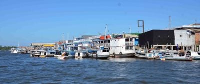
The town connects to major northern Brazilian cities by river transport on the Tocantins, with regular boat services for passengers and cargo. The flat terrain makes it easy to navigate on foot, while proximity to the water is a constant feature of daily life.

The meeting of multiple river systems creates a network of water channels that residents use for daily trips and fishing. These waterways are so woven into life that they shape how people move through and around the town.

The community of curious travelers

AroundUs brings together thousands of curated places, local tips, and hidden gems, enriched daily by 60,000 contributors worldwide.

Start exploring
Location
Inception
1635
Elevation above the sea
1 m
Shares border with
Limoeiro do Ajuru, Igarapé-Miri, Mocajuba, Oeiras do Pará
GPS coordinates
-2.24389,-49.49583
Latest update
December 20, 2025 15:22
« Cametá - Municipality on Tocantins River in Pará, Brazil » is provided by Around Us (aroundus.com). Images and texts are derived from Wikimedia project under a Creative Commons license. You are allowed to copy, distribute, and modify copies of this page, under the conditions set by the license, as long as this note is clearly visible.

Discover hidden gems everywhere you go!

From secret cafés to breathtaking viewpoints, skip the crowded tourist spots and find places that match your style. Our app makes it easy with voice search, smart filtering, route optimization, and insider tips from travelers worldwide. Download now for the complete mobile experience.

Around Us App Screenshot

A unique approach to discovering new places

Le Figaro

All the places worth exploring

France Info

A tailor-made excursion in just a few clicks

20 Minutes

Around Us
Travel Guide & Maps
Download

Send to your phone

QR Code
1

Open the camera app on your mobile.

2

Point at the QR code with your camera. A notification will appear.

3

Tap the notification to open the link.