·

Enable Location

We need your location to show you interesting places around you

Discover nearby places

Find interesting locations and hidden gems around you

Precise directions

Get accurate directions and distances to places

Your location is never shared with other users. It's only used when you tap the location button.

São Bento

Log in to your account

Start exploring — it's free

Trusted by 62,638 travelers worldwide

Continue with Google
Continue with Apple
or

We will send you a code to connect

By continuing, you accept our Terms and Conditions and our Privacy Policy

Check your inbox

We've sent a pincode in your inbox. Please enter the code below.

São Bento, Agricultural municipality in Paraíba, Brazil.

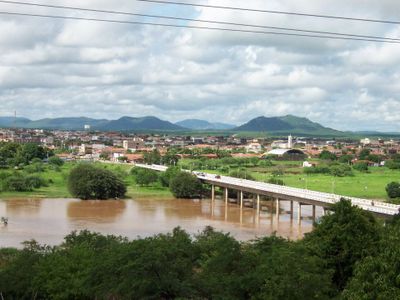
São Bento is a municipality in northeastern Brazil located in Paraíba state, encompassing agricultural regions and residential communities. The landscape combines farmland and small neighborhoods that form the core of local daily life.

The settlement took shape in the late 1800s as the first residents arrived and established homes in the region. It received official municipality status in 1959 after growing into a stable community.

The municipality organizes the Arraiá Shaking Network festival each July, drawing 30,000 visitors for four nights of traditional music and regional celebrations.

The area is accessible mainly on foot or by local transport, with most places within reasonable distance of each other. The best time to visit is during the drier months when roads and pathways are easier to navigate.

The Rio Piranhas river flows through the area and supports agricultural activities across the region. Local people use the waterway for daily needs and to irrigate their crops.

The community of curious travelers

AroundUs brings together thousands of curated places, local tips, and hidden gems, enriched daily by 60,000 contributors worldwide.

Start exploring
Location
Elevation above the sea
152 m
Shares border with
Paulista, Brejo do Cruz, Catolé do Rocha, Jardim de Piranhas, Riacho dos Cavalos, Serra Negra do Norte
GPS coordinates
-6.48583,-37.45083
Latest update
December 22, 2025 13:11
« São Bento - Agricultural municipality in Paraíba, Brazil » is provided by Around Us (aroundus.com). Images and texts are derived from Wikimedia project under a Creative Commons license. You are allowed to copy, distribute, and modify copies of this page, under the conditions set by the license, as long as this note is clearly visible.

Discover hidden gems everywhere you go!

From secret cafés to breathtaking viewpoints, skip the crowded tourist spots and find places that match your style. Our app makes it easy with voice search, smart filtering, route optimization, and insider tips from travelers worldwide. Download now for the complete mobile experience.

Around Us App Screenshot

A unique approach to discovering new places

Le Figaro

All the places worth exploring

France Info

A tailor-made excursion in just a few clicks

20 Minutes

Around Us
Travel Guide & Maps
Download

Send to your phone

QR Code
1

Open the camera app on your mobile.

2

Point at the QR code with your camera. A notification will appear.

3

Tap the notification to open the link.