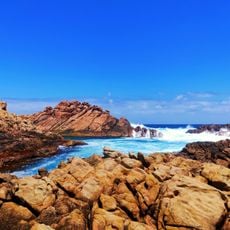
Sugarloaf Rock, Rock formation in Leeuwin-Naturaliste National Park, Western Australia.
Sugarloaf Rock is a large natural granite island in the Indian Ocean, about 2 kilometres south of Cape Naturaliste. It is separated from the mainland by a thin channel of water. Its name comes from its conical shape, reminiscent of an old-style sugarloaf.
Until the mid-1930s no road reached the shore below Sugarloaf Rock; in 1932 visitors scrambled through thickets and down the cliff to get there. The first recorded drowning off the rock occurred in 1934, when a man was washed from it, and a danger sign was erected near the site later that year. Two fishermen drowned when washed off the rock in 1940, while a third survived by clinging to a ledge and raising the alarm.
The rock is a designated nature reserve and a nesting site for seabirds such as the red-tailed tropicbird. Its name comes from its conical shape, which resembles an old-style sugarloaf. The Cape to Cape track passes by the lookout to the rock.
No road reached the shore until the mid-1930s; in 1932 visitors scrambled through thickets and down the cliff to get to the coast. A danger sign went up in 1934 after a man was washed from the rock, and two fishermen drowned there in 1940. The Cape to Cape track passes the lookout above the channel.
Sugarloaf Rock appeared on the cover of Australian Geographic magazine, which helped make it one of the most photographed spots on this coast. The Cape to Cape track runs past the lookout above the rock, so walkers on the long-distance route see it without leaving the trail.
The community of curious travelers
AroundUs brings together thousands of curated places, local tips, and hidden gems, enriched daily by 93,960 contributors worldwide.