Mount Augustus National Park
Mount Augustus National Park, Nature reserve in Upper Gascoyne, Western Australia.
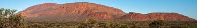
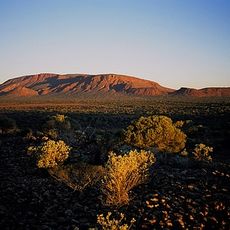
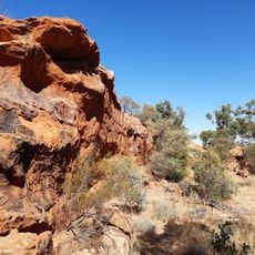
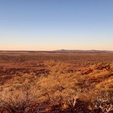
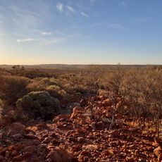
Mount Augustus National Park protects a massive rock rise that climbs 715 meters above the flat surroundings and dominates the arid interior of Western Australia. The formation extends across roughly 9,168 hectares and displays exposed sandstone layers shaped by erosion into sharp ridges and broad valleys.
The geological structure formed more than 1.6 billion years ago, when minerals deposited in shallow ocean basins and were later lifted by movements of the Earth's crust. Recognition as a protected area came in 1989 to safeguard this extraordinary rock formation permanently.
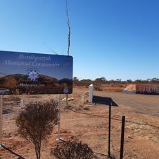
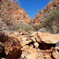
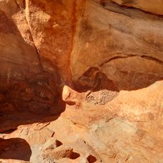
Traditional owners of the land call the mountain Burringurrah and preserve their connection through rock paintings visible at several sites along the walking paths. Visitors encounter these depictions especially in the sheltered spaces of natural overhangs, where the art has been renewed across generations.
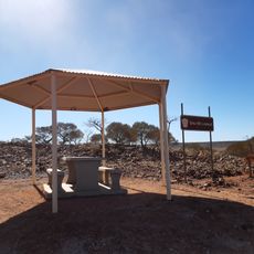
Access follows an unsealed road that requires a four-wheel-drive vehicle and takes several hours from the nearest major settlements. Visitors should be self-sufficient for all needs, as there are no shops, fuel stations, or fresh water supplies inside the park.
The rock formation is classified geologically as a monocline, a single continuous fold that extends over eight kilometers and is larger than Ayers Rock, often mentioned for comparison. Hikers can observe the unusual layer tilt especially well on the southern side, where the rock runs at a clear angle to the surface.
Location: Shire Of Upper Gascoyne
Inception: 1989
Elevation above the sea: 1,032 m
Website: http://naturebase.net/component/option,com_hotproperty/task,view/id,58
GPS coordinates: -24.33207,116.84970
Latest update: December 5, 2025 22:26
Mount Augustus
1.1 km
Karijini National Park
258.7 km
Australian Square Kilometre Array Pathfinder
264 km
Murchison Radio-astronomy Observatory
264.6 km
Kennedy Range National Park
184.4 km
Experiment to Detect the Global EoR Signature
264.1 km
Burringurrah Community
37.7 km
Mount Augustus National Park
601 m
Kotka Gorge Trail, Mount Augustus National Park
2.8 km
Killili Bridge, Gascoyne River
183.7 km
Ooramboo Trail, Mount Augustus National Park
4.3 km
Gascoyne Junction Community Resource Centre
184.4 km
Hamersley Gorge
258.5 km
Upper Gascoyne Road Board Office
184.4 km
Honeycomb Gorge, Kennedy Range National Park
173.2 km
Hancock Gorge
264.1 km
Saddle Trail, Mount Augustus National Park
6.9 km
Original Cobra Station Homestead
47 km
Mount Augustus Tourist Park
6.6 km
Weano Gorge
264.5 km
Temple Gorge, Kennedy Range National Park
174 km
Sunrise View, Kennedy Range National Park
172.4 km
Joffre Gorge
260.2 km
Goordgeela Lookout Trail, Mount Augustus National Park
4.6 km
Mundee, Mount Augustus National Park
3.9 km
Drapers Gorge, Kennedy Range National Park
174.2 km
Emu Hill Lookout
10.3 km
Escarpment trail, Kennedy Range National Park
173.8 kmReviews
Visited this place? Tap the stars to rate it and share your experience / photos with the community! Try now! You can cancel it anytime.
Discover hidden gems everywhere you go!
From secret cafés to breathtaking viewpoints, skip the crowded tourist spots and find places that match your style. Our app makes it easy with voice search, smart filtering, route optimization, and insider tips from travelers worldwide. Download now for the complete mobile experience.
A unique approach to discovering new places❞
— Le Figaro
All the places worth exploring❞
— France Info
A tailor-made excursion in just a few clicks❞
— 20 Minutes