Ogan Ilir, Administrative region in South Sumatra, Indonesia.
Ogan Ilir is an administrative region in South Sumatra that consists of multiple districts and many villages with Indralaya serving as its administrative center. The area spreads across flat terrain and is connected by rivers and local road networks that link the settlements together.
The territory was organized under Dutch colonial administration in the early 1900s and later gained the status of an independent district in the early 2000s. Its separation from a neighboring administrative area shaped how it developed into its current form.
The region is home to communities who have lived here for generations, including the Ogan people and other local groups who maintain their own traditions and ways of living. These communities shape how the villages and towns feel in their daily rhythms and gatherings.
The region is well connected to nearby cities and offers access to local markets and shops in village centers. Visitors should come prepared for tropical weather and plan visits during months with lower humidity.
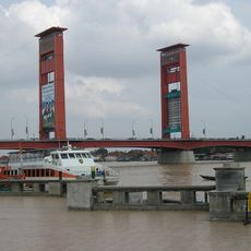
The main town of Indralaya is known for its local architecture and religious structures that reflect the area's heritage. These buildings show how residents have shaped their surroundings over generations.
Location: South Sumatra
Capital city: Indralaya
Elevation above the sea: 21 m
Shares border with: Palembang, Banyuasin, Ogan Komering Ilir, East Ogan Komering Ulu, Ogan Komering Ulu, Muara Enim, Prabumulih
Website: http://oganilirkab.go.id/
GPS coordinates: -3.43186,104.62727
Latest update: December 20, 2025 16:21
Ampera Bridge
51.3 km
Gelora Sriwijaya Stadium
49.1 kmKuto Besak
51.1 km
Muhammad Cheng Hoo Mosque
48.3 km
Sultan Mahmud Badaruddin II Museum
51.4 km
Palembang Water Tower
51.1 kmSriwijaya Kingdom Archaeological Park
47.9 kmSongket Museum
49.9 kmSouth Sumatra Textile Museum
51.1 kmRumah Saudagar Ong Boen Tjit
50 kmTugu Timbangan
25.9 kmSumatera's railway devided into two in here
43.6 kmDANAU KIBEKAN
32.5 kmDanau Wisata Teluk Gelam
23.8 kmAl-akbar Qur'an Museum
47.6 kmTugu Parameswara
48.9 kmLokasi Finisher Apri rusak
46.1 kmCempaka
32.1 kmBayt Al-Qur'an Al-Akbar
47.6 kmTugu Pendidikan
24.4 kmTugu Unsri
24.4 kmTugu Unsri
24.8 kmSculpture, Work of art
45.5 kmLokasi Finisher Apri AMP
46.1 kmMonument
49 kmTugu Taman Kota Prabujaya
42.3 kmTugu Simpang Muara Meranjat
16.6 kmTUGU NANAS
49.3 kmVisited this place? Tap the stars to rate it and share your experience / photos with the community! Try now! You can cancel it anytime.
Discover hidden gems everywhere you go!
From secret cafés to breathtaking viewpoints, skip the crowded tourist spots and find places that match your style. Our app makes it easy with voice search, smart filtering, route optimization, and insider tips from travelers worldwide. Download now for the complete mobile experience.
A unique approach to discovering new places❞
— Le Figaro
All the places worth exploring❞
— France Info
A tailor-made excursion in just a few clicks❞
— 20 Minutes