Chest opened
+${chestReward.xp} XP
Explorer
NOUVEAU ×${chestReward.collectible.quantity}
tapez pour fermer
Chest locked

Open chests in the app

Around Us is built for your phone — chests unlock when you walk, explore and capture nearby places.

Enable Location

We need your location to show you interesting places around you

Discover nearby places

Find interesting locations and hidden gems around you

Precise directions

Get accurate directions and distances to places

Your location is never shared with other users. It's only used when you tap the location button.

Warragul

Log in to your account

Start exploring — it's free

Trusted by 72,878 travelers worldwide

Continue with Google
Continue with Apple
or

We will send you a code to connect

By continuing, you accept our Terms and Conditions and our Privacy Policy

Check your inbox

We've sent a pincode in your inbox. Please enter the code below.

Discussion Reviews 2 Photos
26.4k Popularity

Warragul, Administrative center in Victoria, Australia

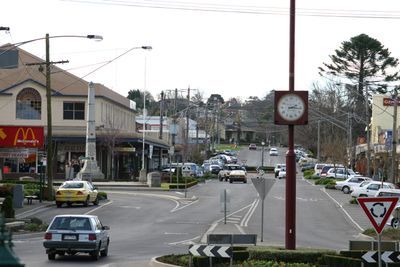
Warragul is the administrative center of Shire of Baw Baw in Victoria, located about 102 kilometers southeast of Melbourne. The town sits in a region between the Strzelecki Ranges to the south and Mount Baw Baw Plateau to the north, where it serves as the main service hub for West Gippsland.

The town's origins trace to a construction camp at McLeod's Track in the 1870s. This led to an official survey and land sales in 1878, marking the establishment of the modern settlement.

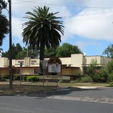
The West Gippsland Arts Centre presents performances and exhibitions that reflect the region's artistic life. The Historical Society Museum holds objects and stories that show how the area has developed over time.

The town has hospitals, schools, and connections to other regions, making it a practical base for exploring West Gippsland. Visitors will find most services they need for a longer stay in the area.

The region is known for its dairy production, with numerous farms around the town supplying a large portion of Melbourne's milk. This agricultural tradition shapes the area's appearance and economy to this day.

The community of curious travelers

AroundUs brings together thousands of curated places, local tips, and hidden gems, enriched daily by 60,000 contributors worldwide.

Start exploring
Location
Location
Elevation above the sea
135 m
Part of
Warragul - Drouin
Shares border with
Brandy Creek, Lillico, Buln Buln, Nilma North, Bona Vista, Nilma, Warragul South, Drouin East, Drouin, Warragul West
GPS coordinates
-38.17000,145.95000
Latest update
December 20, 2025 15:12
Reviews
Share your experience

No review yet

Discussions
Start a discussion...

No discussion yet

« Warragul - Administrative center in Victoria, Australia » is provided by Around Us (aroundus.com). Images and texts are derived from Wikimedia project under a Creative Commons license. You are allowed to copy, distribute, and modify copies of this page, under the conditions set by the license, as long as this note is clearly visible.

Discover hidden gems everywhere you go!

From secret cafés to breathtaking viewpoints, skip the crowded tourist spots and find places that match your style. Our app makes it easy with voice search, smart filtering, route optimization, and insider tips from travelers worldwide. Download now for the complete mobile experience.

Around Us App Screenshot

A unique approach to discovering new places

Le Figaro

All the places worth exploring

France Info

A tailor-made excursion in just a few clicks

20 Minutes

Around Us
Travel Guide & Maps
Download

Send to your phone

QR Code
1

Open the camera app on your mobile.

2

Point at the QR code with your camera. A notification will appear.

3

Tap the notification to open the link.