Lake Mulwala

Log in to your account

AroundUs is a community-driven map of interesting places, built by curious explorers like you. It grows with every review, story, and photo you share.
Connect to save your favorite spots, contribute locations, and create personalized routes.
Continue with Google
Continue with Apple
Continue with X
Continue with Facebook
Continue with email
By continuing, you accept our Terms and Conditions and our Privacy Policy
Create an account

Lake Mulwala

Add to collection
Map
Suggest a change
Share

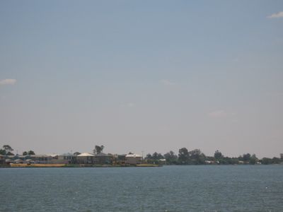
Lake Mulwala, Artificial reservoir between Bundalong and Yarrawonga, Australia.

Lake Mulwala is an artificial reservoir that spans across the Murray River and covers about 43,900 hectares of water surface. The lake sits at about 124 meters elevation and stretches between Bundalong and Yarrawonga.

The reservoir formed in 1939 when the Yarrawonga Weir was built to provide irrigation water for farmland. This dam project changed the region and made agriculture possible across both states.

The lake serves as a natural meeting place between two states, and people from both sides have long shared its waters for fishing and boating. Locals and visitors use it as a gathering spot where they can spend time together and enjoy outdoor activities.

The shoreline has several boat ramps and designated swimming areas that are easy to find and use. Parking is available at various spots along the water, and fishing locations are well-established around the lake.

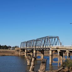
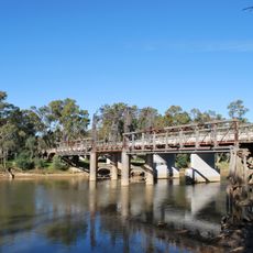
The Mulwala Bridge that crosses the lake has an unexpected dip and curve due to poor coordination between the two states during construction in the 1920s. This quirk remains visible to this day when you drive or walk across it.

Location: New South Wales

Elevation above the sea: 124 m

GPS coordinates: -36.00936,146.09287

Latest update: December 8, 2025 19:53

Photos
Reviews

Visited this place? Tap the stars to rate it and share your experience / photos with the community! Try now! You can cancel it anytime.

« Lake Mulwala - Artificial reservoir between Bundalong and Yarrawonga, Australia » is provided by Around Us (aroundus.com). Images and texts are derived from Wikimedia project under a Creative Commons license. You are allowed to copy, distribute, and modify copies of this page, under the conditions set by the license, as long as this note is clearly visible.

Discover hidden gems everywhere you go!

From secret cafés to breathtaking viewpoints, skip the crowded tourist spots and find places that match your style. Our app makes it easy with voice search, smart filtering, route optimization, and insider tips from travelers worldwide. Download now for the complete mobile experience.

Around Us App Screenshot

A unique approach to discovering new places

Le Figaro

All the places worth exploring

France Info

A tailor-made excursion in just a few clicks

20 Minutes