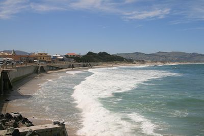
Saint Clair Beach, Ocean beach in Dunedin, New Zealand.
Saint Clair Beach stretches for several kilometers along the southeastern coast with light-colored sand and regular waves. The shore combines a natural bathing experience with a recognized surfing zone.
The area was developed in the 1850s by William Henry Valpy, who named it after English gardens. It has since grown into a popular coastal destination.
The beach draws surfers who regularly train and compete here throughout the year. It has become an established spot within New Zealand's surfing community.
The beach is easily accessible by public transport with designated access points at several locations. Visitors should check tide times to choose the best period for swimming or surfing.
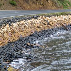
The western section features a natural rock pool filled with salt water that offers swimmers a calmer spot away from the main waves. The basin is integrated into the rocky formation and creates a sheltered space.
Location: Dunedin City
Part of: Ocean Beach
GPS coordinates: -45.91200,170.49100
Latest update: December 6, 2025 19:07
New Zealand provides photographic subjects ranging from the Southern Alps to sand beaches on both coastlines. The landscape includes thermal springs in Rotorua, glaciers like Franz Josef and Tasman, and fjords in Fiordland. Mount Cook dominates the alpine region while the Coromandel Peninsula holds beaches including Hot Water Beach and Cathedral Cove. The Tongariro Alpine Crossing traverses volcanic terrain and Mount Taranaki rises above Taranaki. Coastal formations like the Moeraki Boulders, Split Apple Rock and Nugget Point demonstrate geological variety. Natural waterfalls including Purakaunui Falls and Whangarei Falls sit among native forests. Cultural sites complement the natural geography. The Hobbiton Movie Set near Matamata displays the film location from the Tolkien adaptation. Larnach Castle near Dunedin represents colonial architecture. Te Puia and Wai-O-Tapu demonstrate geothermal activity with geysers and colored pools. Waitomo Caves contains glowworm caverns. Lake Tekapo offers clear night skies for stargazing. Viewpoints like Roy's Peak near Wanaka and Queenstown Hill sit above lake landscapes. Remote regions including Cape Reinga at the northern tip and Cape Palliser in the Wairarapa show different coastal environments. The Forgotten World Highway crosses historic mountain country on the North Island.
Tunnel Beach
2.7 km
Cargill's Castle
1 km
Ocean Beach Railway
1.6 km
Dunedin Ice Stadium
1.2 km
St Patrick's Basilica, South Dunedin
2.1 km
St Michael's Antiochian Orthodox Church
1.9 km
St Matthew's Church, Dunedin
3.6 km
Dunedin Gasworks Museum
2.3 km
Mayfair Theatre
2.2 km
Empire Hotel
3.6 km
St Andrew's Presbyterian Church
3.4 km
Andersons Bay Presbyterian Church (Former)
3.5 km
Pinner House
321 m
Caversham Presbyterian Church
1.7 km
Moata
3.4 km
Threave
3.5 km
Donaghy's Rope Walk
1.6 km
Crown Milling Company building
3.4 km
High Street School War Memorial and Gates
3.4 km
Gasholder of 1879
2.2 km
Mornington Post Office
3.4 km
Ramsay Lodge
3.5 km
Otago Harbour Seawalls
3.1 km
Kempthorne Prosser Building
3.6 km
Shacklock Buildings
3.2 km
Lisburn House
2 km
Sew Hoy's Building
3.6 km
Dunedin Club
3.1 kmVisited this place? Tap the stars to rate it and share your experience / photos with the community! Try now! You can cancel it anytime.
Discover hidden gems everywhere you go!
From secret cafés to breathtaking viewpoints, skip the crowded tourist spots and find places that match your style. Our app makes it easy with voice search, smart filtering, route optimization, and insider tips from travelers worldwide. Download now for the complete mobile experience.
A unique approach to discovering new places❞
— Le Figaro
All the places worth exploring❞
— France Info
A tailor-made excursion in just a few clicks❞
— 20 Minutes