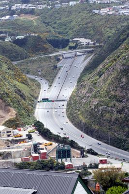
Ngauranga Gorge, Canyon and road system in Wellington, New Zealand
Ngauranga Gorge is a natural chasm carved through steep cliffs and geological formations that connects Wellington City to its northern suburbs. A six-lane highway cuts through this landscape, featuring a major interchange with elevated roadways that directs traffic between two state highways.
Development of the Ngauranga Gorge road began in 1853 when residents formed an association to create an alternative route avoiding the Ngaio Gorge path. Major roadwork in the 1960s expanded the passage and produced excavated materials that were repurposed for harbor reclamation projects in Wellington.
The name comes from Ngā Hauranga pā, a historical Māori settlement that once stood at the base of this gorge, with the simplified spelling adopted after World War II. Walking through this area, you can sense the connection between the modern transport corridor and its indigenous roots.
The gorge experiences heavy traffic flow during peak hours, so plan visits or travel outside these busy times if possible. Keep in mind this is primarily a vehicle corridor with limited pedestrian and cycling access, so it is best viewed from a car.
The gorge is home to local birds of prey that glide over the cliff faces, particularly visible during quieter morning and evening hours. Observers report these flying residents regularly circle above the highway traffic undisturbed by the activity below.
The community of curious travelers
AroundUs brings together thousands of curated places, local tips, and hidden gems, enriched daily by 60,000 contributors worldwide.