Enable Location

We need your location to show you interesting places around you

Discover nearby places

Find interesting locations and hidden gems around you

Precise directions

Get accurate directions and distances to places

Your location is never shared with other users. It's only used when you tap the location button.

Napier Hill

Log in to your account

Start exploring — it's free

Trusted by 62,830 travelers worldwide

Continue with Google
Continue with Apple
or

We will send you a code to connect

By continuing, you accept our Terms and Conditions and our Privacy Policy

Check your inbox

We've sent a pincode in your inbox. Please enter the code below.

Napier Hill

Napier Hill, Limestone outcrop in Napier, New Zealand

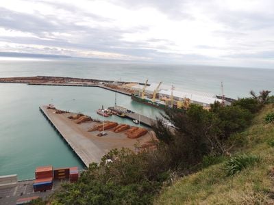
Napier Hill is a limestone formation that rises above the city's lower districts, with steep cliffs overlooking the port on its northeastern side. The western section, called Hospital Hill, now features a modern water reservoir built where the old Napier Hospital once stood until 1999.

Before the 1931 earthquake, this landform existed as an island called Scinde Island, named after the Sindh region of India and surrounded by water. The earthquake dramatically reshaped the geography and joined the island to the mainland.

Schools located on the slopes shape daily life as students move through the area throughout the day. These institutions have become part of the neighborhood's rhythm and how people navigate the hill.

The hill is accessible via various paths and stairs that lead through residential areas. Sturdy footwear is advisable as some sections are steep, and the upper areas offer the best views of the surrounding landscape.

The Napier Botanical Gardens located on the hill were established in the 1860s and were the city's first public park. Visitors often overlook this quiet garden space tucked within the residential slopes.

The community of curious travelers

AroundUs brings together thousands of curated places, local tips, and hidden gems, enriched daily by 60,000 contributors worldwide.

Start exploring
GPS coordinates
-39.47975,176.91053
Latest update
December 12, 2025 16:40
« Napier Hill - Limestone outcrop in Napier, New Zealand » is provided by Around Us (aroundus.com). Images and texts are derived from Wikimedia project under a Creative Commons license. You are allowed to copy, distribute, and modify copies of this page, under the conditions set by the license, as long as this note is clearly visible.

Discover hidden gems everywhere you go!

From secret cafés to breathtaking viewpoints, skip the crowded tourist spots and find places that match your style. Our app makes it easy with voice search, smart filtering, route optimization, and insider tips from travelers worldwide. Download now for the complete mobile experience.

Around Us App Screenshot

A unique approach to discovering new places

Le Figaro

All the places worth exploring

France Info

A tailor-made excursion in just a few clicks

20 Minutes

Around Us
Travel Guide & Maps
Download

Send to your phone

QR Code
1

Open the camera app on your mobile.

2

Point at the QR code with your camera. A notification will appear.

3

Tap the notification to open the link.