Chest opened
+${chestReward.xp} XP
Explorer
NOUVEAU ×${chestReward.collectible.quantity}
tapez pour fermer
Chest locked

Open chests in the app

Around Us is built for your phone — chests unlock when you walk, explore and capture nearby places.

Enable Location

We need your location to show you interesting places around you

Discover nearby places

Find interesting locations and hidden gems around you

Precise directions

Get accurate directions and distances to places

Your location is never shared with other users. It's only used when you tap the location button.

Burra

Log in to your account

Start exploring — it's free

Trusted by 72,888 travelers worldwide

Continue with Google
Continue with Apple
or

We will send you a code to connect

By continuing, you accept our Terms and Conditions and our Privacy Policy

Check your inbox

We've sent a pincode in your inbox. Please enter the code below.

Discussion Reviews 1 Photos
21.4k Popularity

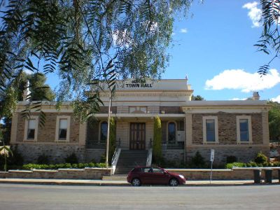
Burra, Administrative center in The Regional Council of Goyder, Australia

Burra is a town in the Goyder region of South Australia that developed around copper mining operations and features numerous preserved structures from that era. The settlement continues to serve as a local administrative hub for the surrounding area.

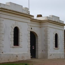
Copper was discovered in the area in 1845, triggering rapid growth as mining operations expanded and the settlement became one of the colony's major centers. The wealth generated by this industry shaped its early development and importance.

The town's identity remains rooted in its copper mining heritage, visible in how the landscape was shaped and reshaped by extraction work. Walking through the streets, you notice how local buildings, layout, and daily life still reflect these mining origins.

The town is easy to navigate on foot, with preserved mining structures and heritage sites spread across the area for visitors to explore at their own pace. Wear sturdy shoes since many historical sites involve uneven ground and older structures.

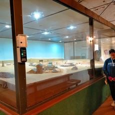
Underground tunnels run beneath the town streets, originally dug for mining and now accessible as spaces that hold equipment and records from the 19th century. These passages reveal how miners worked far below the surface in difficult conditions.

The community of curious travelers

AroundUs brings together thousands of curated places, local tips, and hidden gems, enriched daily by 60,000 contributors worldwide.

Start exploring
Location
Location
Elevation above the sea
472 m
Shares border with
Porter Lagoon, Baldina, Worlds End, Koonoona, Emu Downs, Gum Creek, Hanson, Booborowie, Mongolata, Mount Bryan, Leighton, Mount Bryan East
GPS coordinates
-33.66667,138.93333
Latest update
December 23, 2025 20:18
Reviews
Share your experience

No review yet

Discussions
Start a discussion...

No discussion yet

« Burra - Administrative center in The Regional Council of Goyder, Australia » is provided by Around Us (aroundus.com). Images and texts are derived from Wikimedia project under a Creative Commons license. You are allowed to copy, distribute, and modify copies of this page, under the conditions set by the license, as long as this note is clearly visible.

Discover hidden gems everywhere you go!

From secret cafés to breathtaking viewpoints, skip the crowded tourist spots and find places that match your style. Our app makes it easy with voice search, smart filtering, route optimization, and insider tips from travelers worldwide. Download now for the complete mobile experience.

Around Us App Screenshot

A unique approach to discovering new places

Le Figaro

All the places worth exploring

France Info

A tailor-made excursion in just a few clicks

20 Minutes

Around Us
Travel Guide & Maps
Download

Send to your phone

QR Code
1

Open the camera app on your mobile.

2

Point at the QR code with your camera. A notification will appear.

3

Tap the notification to open the link.