Chest opened
+${chestReward.xp} XP
Explorer
NOUVEAU ×${chestReward.collectible.quantity}
tapez pour fermer
Chest locked

Open chests in the app

Around Us is built for your phone — chests unlock when you walk, explore and capture nearby places.

Enable Location

We need your location to show you interesting places around you

Discover nearby places

Find interesting locations and hidden gems around you

Precise directions

Get accurate directions and distances to places

Your location is never shared with other users. It's only used when you tap the location button.

Glen Innes

Log in to your account

Start exploring — it's free

Trusted by 72,885 travelers worldwide

Continue with Google
Continue with Apple
or

We will send you a code to connect

By continuing, you accept our Terms and Conditions and our Privacy Policy

Check your inbox

We've sent a pincode in your inbox. Please enter the code below.

Discussion Reviews 2 Photos
32.8k Popularity

Glen Innes, Regional administrative center in New South Wales, Australia

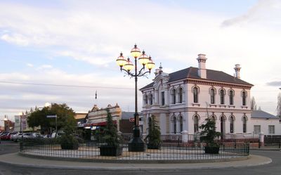
Glen Innes is a regional administrative center located on the Northern Tablelands where the New England Highway and Gwydir Highway intersect. The town serves as the local government base for this area of New South Wales.

The Ngarabal people originally called this land Gindaaydjin before European settlers arrived in 1838, when Archibald Boyd established the first registered settlement. The town grew to become the administrative center it is today.

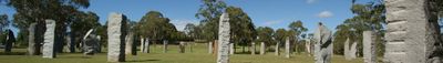
The Australian Standing Stones monument displays large granite blocks arranged in a calendar layout that merges Celtic and Southern Cross symbols. This design reflects how the community has chosen to represent its cultural connections and local heritage.

The Glen Innes Visitor Information Centre offers fossicking maps for those interested in searching for gold and precious stones in the surrounding areas. These resources make it easy for visitors to explore the region's geological treasures.

The region contains sections of the Gondwana Rainforests World Heritage Area, including Washpool National Park with distinctive forest and native wildlife. These protected areas make the region a significant place for observing natural features and local animal species.

The community of curious travelers

AroundUs brings together thousands of curated places, local tips, and hidden gems, enriched daily by 60,000 contributors worldwide.

Start exploring
Location
Location
Elevation above the sea
1,071 m
Shares border with
Reddestone, Wellingrove, Furracabad, Lambs Valley, Matheson, Shannon Vale, Stonehenge, Yarrowford
GPS coordinates
-29.75000,151.73611
Latest update
March 4, 2026 16:15
Reviews
Share your experience

No review yet

Discussions
Start a discussion...

No discussion yet

« Glen Innes - Regional administrative center in New South Wales, Australia » is provided by Around Us (aroundus.com). Images and texts are derived from Wikimedia project under a Creative Commons license. You are allowed to copy, distribute, and modify copies of this page, under the conditions set by the license, as long as this note is clearly visible.

Discover hidden gems everywhere you go!

From secret cafés to breathtaking viewpoints, skip the crowded tourist spots and find places that match your style. Our app makes it easy with voice search, smart filtering, route optimization, and insider tips from travelers worldwide. Download now for the complete mobile experience.

Around Us App Screenshot

A unique approach to discovering new places

Le Figaro

All the places worth exploring

France Info

A tailor-made excursion in just a few clicks

20 Minutes

Around Us
Travel Guide & Maps
Download

Send to your phone

QR Code
1

Open the camera app on your mobile.

2

Point at the QR code with your camera. A notification will appear.

3

Tap the notification to open the link.