Mount Bellenden Ker, Granite mountain in Queensland, Australia
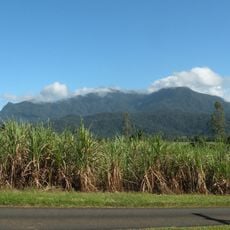
Mount Bellenden Ker is a granite peak reaching 1,593 metres, the second-highest mountain in Queensland. It stands 39 km south of Cairns near Babinda, beside Mount Bartle Frere, in the Bellenden Ker Range also called the Wooroonooran Range. Both peaks are eroded remnants of an escarpment cut by the Russell and Mulgrave Rivers. Its summit carries television transmitter towers and a weather station reached only by a privately owned cable car.
In 1873 Walter Hill, Queensland's first colonial botanist, visited the mountain while collecting native plants. That same year Robert Arthur Johnstone climbed the peak during an exploration of coastal lands south of Cooktown with George Elphinstone Dalrymple. Archibald Meston led another summit expedition from early February to early March 1889.
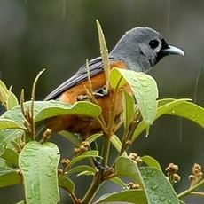
The mountain lies in the Wooroonooran Important Bird Area, listed by BirdLife International for its populations of birds endemic to Queensland's Wet Tropics. Its name honours botanist John Bellenden Ker Gawler, and the summit's cloud forest, often under fog, is noted for high biodiversity.
The summit is not freely accessible to the public due to the broadcasting and weather monitoring infrastructure located there. Visitors can explore the surrounding parkland and forested slopes of the mountain range instead.
The summit rain gauge holds Australia's calendar-year rainfall record: 12,461 mm in 2000. In January 1979 it also logged 5,387 mm in a single month, the highest monthly total recorded in the country. The average there is about 8,053 mm a year.
The community of curious travelers
AroundUs brings together thousands of curated places, local tips, and hidden gems, enriched daily by 92,699 contributors worldwide.