Enable Location

We need your location to show you interesting places around you

Discover nearby places

Find interesting locations and hidden gems around you

Precise directions

Get accurate directions and distances to places

Your location is never shared with other users. It's only used when you tap the location button.

Tombstone Territorial Park

Log in to your account

Start exploring — it's free

Trusted by 62,352 travelers worldwide

Continue with Google
Continue with Apple
or

We will send you a code to connect

By continuing, you accept our Terms and Conditions and our Privacy Policy

Check your inbox

We've sent a pincode in your inbox. Please enter the code below.

Tombstone Territorial Park

Tombstone Territorial Park, Provincial park in Yukon, Canada

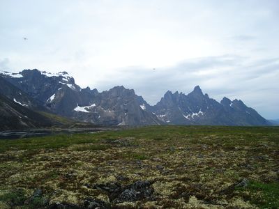
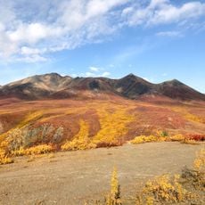
Tombstone Territorial Park is a provincial park in Yukon covering 2100 square kilometers of mountainous terrain with sharp peaks and permafrost formations. The landscape supports caribou and grizzly bears and is accessed through an interpretive center near Dempster Highway plus three camping areas at Grizzly, Divide, and Talus Lakes.

Scientists identified sensitive sites in the 1970s, leading to protection measures during Dempster Highway construction. These early conservation efforts formed the foundation for the park's eventual establishment.

The park is jointly managed by territorial authorities and the Tr'ondëk Hwëch'in First Nation, preserving the region's physical, biological, and archaeological character. Visitors can see how this shared stewardship shapes how the land is cared for and respected.

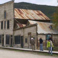
The interpretive center sits near Dempster Highway and offers information plus resources for backcountry travel. Visitors should check conditions and seasons before visiting, as this area is remote and exposed to harsh weather.

Mount Monolith and Tombstone Mountain stand as distinctive peaks marking a watershed divide between the Yukon River and Mackenzie River systems. This geographic meeting point makes the park notable for where two major river systems converge.

The community of curious travelers

AroundUs brings together thousands of curated places, local tips, and hidden gems, enriched daily by 60,000 contributors worldwide.

Start exploring
Location
Inception
2000
GPS coordinates
64.57569,-138.47906
Latest update
December 6, 2025 16:04
Remote natural areas and historic sites in Yukon

The Yukon Territory in northern Canada holds a collection of natural areas and historical sites located away from main highways. Visitors discover sand dunes, canyons, glacier landscapes, and natural features like Emerald Lake and hot springs. The region shaped its identity through the gold rush...

« Tombstone Territorial Park - Provincial park in Yukon, Canada » is provided by Around Us (aroundus.com). Images and texts are derived from Wikimedia project under a Creative Commons license. You are allowed to copy, distribute, and modify copies of this page, under the conditions set by the license, as long as this note is clearly visible.

Discover hidden gems everywhere you go!

From secret cafés to breathtaking viewpoints, skip the crowded tourist spots and find places that match your style. Our app makes it easy with voice search, smart filtering, route optimization, and insider tips from travelers worldwide. Download now for the complete mobile experience.

Around Us App Screenshot

A unique approach to discovering new places

Le Figaro

All the places worth exploring

France Info

A tailor-made excursion in just a few clicks

20 Minutes

Around Us
Travel Guide & Maps
Download

Send to your phone

QR Code
1

Open the camera app on your mobile.

2

Point at the QR code with your camera. A notification will appear.

3

Tap the notification to open the link.