Coachella Valley, Desert valley in Riverside County, United States
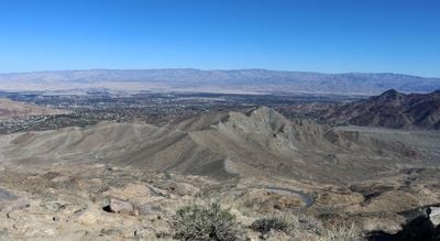
The Coachella Valley is a desert valley in Riverside County stretching 45 miles (72 kilometers) through the Colorado Desert, framed by the San Bernardino Mountains to the north and the Santa Rosa Mountains to the south. The flat valley floor sits mostly below sea level, forming a dry, open expanse between these two mountain ranges.
Cahuilla tribes lived here for thousands of years, using underground water sources before European settlers arrived in the 19th century. Modern development began after irrigation canals were built and the railway opened through the valley in the 1870s.
The valley takes its name from the Cahuilla word kuchilla, meaning water place, referring to the natural springs that once flowed here. Many street names and locations throughout the area still carry Cahuilla language names, a reminder of the original inhabitants.
Interstate 10 runs the full length of the valley and connects all the main towns in the region. Winters are mild and comfortable, while summer months often reach temperatures above 100°F (38°C), so plan accordingly.
The region produces 95 percent of all the dates grown in the United States, mostly around Indio. Each February, the National Date Festival in Indio celebrates this harvest with tastings and agricultural displays.
The community of curious travelers
AroundUs brings together thousands of curated places, local tips, and hidden gems, enriched daily by 60,000 contributors worldwide.