Chest opened
+${chestReward.xp} XP
Explorer
NOUVEAU ×${chestReward.collectible.quantity}
tapez pour fermer
Chest locked

Open chests in the app

Around Us is built for your phone — chests unlock when you walk, explore and capture nearby places.

Enable Location

We need your location to show you interesting places around you

Discover nearby places

Find interesting locations and hidden gems around you

Precise directions

Get accurate directions and distances to places

Your location is never shared with other users. It's only used when you tap the location button.

Sierra Madre Occidental

Log in to your account

Start exploring — it's free

Trusted by 72,983 travelers worldwide

Continue with Google
Continue with Apple
or

We will send you a code to connect

By continuing, you accept our Terms and Conditions and our Privacy Policy

Check your inbox

We've sent a pincode in your inbox. Please enter the code below.

Sierra Madre Occidental
Discussion Reviews 1 Photos
124k Popularity

Sierra Madre Occidental, Mountain range in northwestern Mexico.

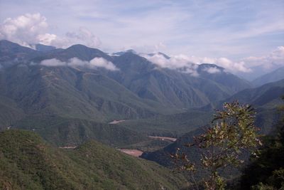
Sierra Madre Occidental is a mountain system in western Mexico stretching more than 700 miles along the Pacific coast. The mountains rise to average elevations between 8000 and 9000 feet and form a massive wall between the highland plateau and the coastal lowlands.

The mountains formed during intense volcanic activity in the Mesozoic Era as magma pushed through the crust. Later erosion carved the deep valleys and canyons that characterize the terrain today.

The name comes from Spanish and means western mother range, describing its position as a parallel chain along the coast. Travelers notice the deep canyons and gorges that shape life in remote villages and form a natural barrier between communities.

Federal Highways 16 and 40 cross through the mountains and connect coastal cities with the interior despite the difficult terrain. Travelers should prepare for winding roads, changing weather conditions, and longer travel times between towns.

The mountains create different rainfall patterns that bring more rain to the Pacific side and drier conditions to the eastern side. This division leads to visibly different vegetation zones, from oak woodlands at lower elevations to pine stands in the higher regions.

The community of curious travelers

AroundUs brings together thousands of curated places, local tips, and hidden gems, enriched daily by 60,000 contributors worldwide.

Start exploring
GPS coordinates
25.94800,-107.03390
Latest update
December 15, 2025 01:50
Reviews
Share your experience

No review yet

Discussions
Start a discussion...

No discussion yet

« Sierra Madre Occidental - Mountain range in northwestern Mexico » is provided by Around Us (aroundus.com). Images and texts are derived from Wikimedia project under a Creative Commons license. You are allowed to copy, distribute, and modify copies of this page, under the conditions set by the license, as long as this note is clearly visible.

Discover hidden gems everywhere you go!

From secret cafés to breathtaking viewpoints, skip the crowded tourist spots and find places that match your style. Our app makes it easy with voice search, smart filtering, route optimization, and insider tips from travelers worldwide. Download now for the complete mobile experience.

Around Us App Screenshot

A unique approach to discovering new places

Le Figaro

All the places worth exploring

France Info

A tailor-made excursion in just a few clicks

20 Minutes

Around Us
Travel Guide & Maps
Download

Send to your phone

QR Code
1

Open the camera app on your mobile.

2

Point at the QR code with your camera. A notification will appear.

3

Tap the notification to open the link.