Chest opened
+${chestReward.xp} XP
Explorer
NOUVEAU ×${chestReward.collectible.quantity}
tapez pour fermer
Chest locked

Open chests in the app

Around Us is built for your phone — chests unlock when you walk, explore and capture nearby places.

Enable Location

We need your location to show you interesting places around you

Discover nearby places

Find interesting locations and hidden gems around you

Precise directions

Get accurate directions and distances to places

Your location is never shared with other users. It's only used when you tap the location button.

Show Low

Log in to your account

Start exploring — it's free

Trusted by 72,881 travelers worldwide

Continue with Google
Continue with Apple
or

We will send you a code to connect

By continuing, you accept our Terms and Conditions and our Privacy Policy

Check your inbox

We've sent a pincode in your inbox. Please enter the code below.

Discussion Reviews 1 Photos
74.8k Popularity

Show Low, Mountain settlement in Navajo County, Arizona, US.

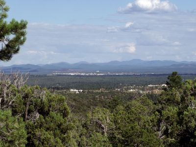
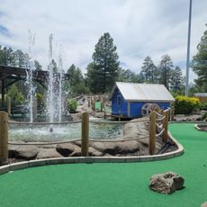
Show Low is a mountain settlement in Navajo County in eastern Arizona, sitting at 6,345 feet elevation in the White Mountains region. The altitude brings cooler temperatures than most of the state and pine forests surround the residential areas.

Pioneers founded the settlement around 1870 during westward expansion and established ranches and farms in the territory. The place slowly grew into a supply center for surrounding agricultural operations.

The poker game between two early settlers who decided land ownership by showing the lowest card still echoes in local stories and gives the settlement its name. This playful origin remains part of how residents see their town and talk about where they come from.

A regional airport offers flights to other parts of Arizona and several highways make driving access straightforward. The elevation means visitors should prepare for thinner air and possible snow during winter months.

The area sits near the Mogollon Rim, a sharp escarpment that separates the Colorado Plateau from lower terrain. This geological edge creates a boundary between different climate zones and plant communities.

The community of curious travelers

AroundUs brings together thousands of curated places, local tips, and hidden gems, enriched daily by 60,000 contributors worldwide.

Start exploring
Location
Inception
1870
GPS coordinates
34.24359,-110.04817
Latest update
March 6, 2026 09:31
Around this place
Snowflake Arizona Temple
United States of America

Snowflake Arizona Temple

29.4 km
United States of America

Scott Reservoir

11.3 km
United States of America

Horseshoe Cienega Lake

40.9 km
United States of America

Woodland Reservoir

15.7 km
United States of America

Pinedale Elementary School

18.7 km
Cedar Canyon Bridge
United States of America

Cedar Canyon Bridge

25.4 km
Lake Mountain Lookout Complex
United States of America

Lake Mountain Lookout Complex

27.4 km
Corduroy Creek Bridge
United States of America

Corduroy Creek Bridge

18 km
White Mountain Family Fun Park
United States of America

White Mountain Family Fun Park

8.7 km
Los Burros Ranger Station
United States of America

Los Burros Ranger Station

28.5 km
United States of America

Pinedale Ranger Station

27.3 km
United States of America

Deer Springs Lookout Complex

35 km
Show Low Historical Society
United States of America

Show Low Historical Society

1.5 km
United States of America

Cyclone Lake

38.6 km
United States of America

Point of the Mountain

34.1 km
United States of America

Pinetop Country Club

21.8 km
United States of America

Birdie Ranch Golf Club at Silver Creek

14.8 km
United States of America

White Mountain Country Club

19.1 km
United States of America

Snowflake Community Golf Course

29.9 km
United States of America

Torreon Golf Course

3.1 km
United States of America

Pinetop Lakes Golf & Country Club

19.8 km

Adair Amphitheater

3.9 km
United States of America

Statue, Work of art

310 m
United States of America

Pat Mullen Scenic Vista

18.1 km
United States of America

Scenic viewpoint

27.4 km
United States of America

Scenic viewpoint

2.4 km
United States of America

Show Low Meadow

2.3 km
United States of America

Aztec Spring Ranch

35.2 km
Show the full map
Reviews
Share your experience

No review yet

Discussions
Start a discussion...

No discussion yet

« Show Low - Mountain settlement in Navajo County, Arizona, US » is provided by Around Us (aroundus.com). Images and texts are derived from Wikimedia project under a Creative Commons license. You are allowed to copy, distribute, and modify copies of this page, under the conditions set by the license, as long as this note is clearly visible.

Discover hidden gems everywhere you go!

From secret cafés to breathtaking viewpoints, skip the crowded tourist spots and find places that match your style. Our app makes it easy with voice search, smart filtering, route optimization, and insider tips from travelers worldwide. Download now for the complete mobile experience.

Around Us App Screenshot

A unique approach to discovering new places

Le Figaro

All the places worth exploring

France Info

A tailor-made excursion in just a few clicks

20 Minutes

Around Us
Travel Guide & Maps
Download

Send to your phone

QR Code
1

Open the camera app on your mobile.

2

Point at the QR code with your camera. A notification will appear.

3

Tap the notification to open the link.