Guna Yala, Indigenous comarca in northeast Panama
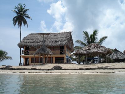
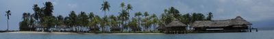
Guna Yala is an autonomous region along the Caribbean coast of Panama that stretches from the mainland to hundreds of small coral islands. The territory includes dense rainforests in the interior and narrow sandy strips offshore lined with coconut palms.
The region became officially autonomous in 1925 after an uprising by the Guna, when the local population defended their rights against state prohibitions. Administration has since remained in the hands of the communities, which organize themselves through their own congress.
The name comes from the Guna language and refers to the land of the people, which they govern according to their own rules. Visitors immediately notice that women here wear traditional mola textiles, colorful hand-stitched fabrics with geometric patterns.
Access is only possible with permission from local authorities, which is checked upon arrival. Small planes connect the region with the capital, while boats shuttle between the islands.
Many of the tiny islands are home to just a few families who build their houses from bamboo and palm leaves. Residents often share the harvest communally and store rainwater in large containers, as there is no piped water supply.
Location: Panama
Shares border with: Panamá Province, Colón Province, Chocó Department
GPS coordinates: 9.29611,-78.34417
Latest update: December 4, 2025 23:04
Panama features a variety of photographic settings, from the colonial district of Casco Viejo to the fine sandy beaches of the San Blas Islands. Panama City combines historic heritage and modern architecture, including Frank Gehry's Biomuseo and the Miraflores locks that showcase canal engineering. Walks such as Cinta Costera or Amador Causeway offer views over the bay and the city skyline. Beyond the city, the country reveals rich and accessible nature. The Baru volcano rises over 3400 meters in Chiriquí province, while the Bocas del Toro archipelago hosts secluded beaches with turquoise waters. Tropical forests, marine reserves, and mountain trails complete this landscape diversity, making Panama a full photographic destination between the Atlantic and Pacific.
Panamá Viejo
129.5 km
Sub Marine Explorer
125.7 km
Chagres National Park
127.5 km
Panamá Viejo Cathedral
129.5 km
Ocean Two
127.1 km
Vitri Tower
127.1 km
Bayano Lake
48.5 km
Iglesia y Convento de las Monjas de la Concepción
129.8 km
Isla Bayoneta
119.3 km
Cancha de Entrenamiento Luis Tapia
127.2 km
Bayano Caves
59.4 km
Ocean One
128.4 km
Punta Patiño
119.1 km
Baha'i House in Panama City
131.8 km
Fortín de la Natividad
130.5 km
Puente del Matadero
130.6 km
Iglesia y Convento de San Francisco
130 km
Puente del Rey
129.4 km
Iglesia y Convento de la Merced
130.3 km
Casa Terrín
129.5 km
Iglesia y Convento de San José
129.4 km
Plaza Mayor
129.5 km
Casas Reales
129.3 km
Iglesia y Convento de Santo Domingo
129.5 km
Casas Oeste
129.6 km
Hospital de San Juan de Dios
129.8 km
Iglesia y Convento de la Compañía de Jesús
129.7 km
Casa Alarcón
129.5 kmReviews
Visited this place? Tap the stars to rate it and share your experience / photos with the community! Try now! You can cancel it anytime.
Discover hidden gems everywhere you go!
From secret cafés to breathtaking viewpoints, skip the crowded tourist spots and find places that match your style. Our app makes it easy with voice search, smart filtering, route optimization, and insider tips from travelers worldwide. Download now for the complete mobile experience.
A unique approach to discovering new places❞
— Le Figaro
All the places worth exploring❞
— France Info
A tailor-made excursion in just a few clicks❞
— 20 Minutes