Panama offers a variety of photo subjects, from the colorful streets of Casco Viejo to the beaches of the San Blas islands and the shipping canal that connects two oceans.
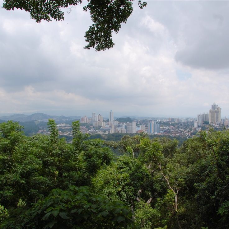
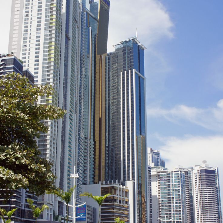
Panama features a variety of photographic settings, from the colonial district of Casco Viejo to the fine sandy beaches of the San Blas Islands. Panama City combines historic heritage and modern architecture, including Frank Gehry's Biomuseo and the Miraflores locks that showcase canal engineering. Walks such as Cinta Costera or Amador Causeway offer views over the bay and the city skyline.
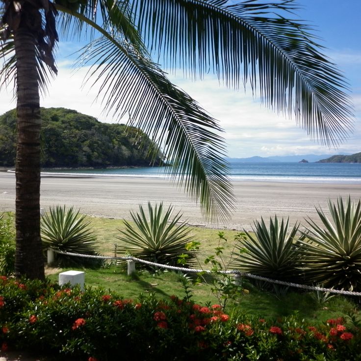
Beyond the city, the country reveals rich and accessible nature. The Baru volcano rises over 3400 meters in Chiriquí province, while the Bocas del Toro archipelago hosts secluded beaches with turquoise waters. Tropical forests, marine reserves, and mountain trails complete this landscape diversity, making Panama a full photographic destination between the Atlantic and Pacific.
Panama offers a variety of photo subjects, from the colorful streets of Casco Viejo to the beaches of the San Blas islands and the shipping canal that connects two oceans.
Panama features a variety of photographic settings, from the colonial district of Casco Viejo to the fine sandy beaches of the San Blas Islands. Panama City combines historic heritage and modern architecture, including Frank Gehry's Biomuseo and the Miraflores locks that showcase canal engineering. Walks such as Cinta Costera or Amador Causeway offer views over the bay and the city skyline.
Beyond the city, the country reveals rich and accessible nature. The Baru volcano rises over 3400 meters in Chiriquí province, while the Bocas del Toro archipelago hosts secluded beaches with turquoise waters. Tropical forests, marine reserves, and mountain trails complete this landscape diversity, making Panama a full photographic destination between the Atlantic and Pacific.
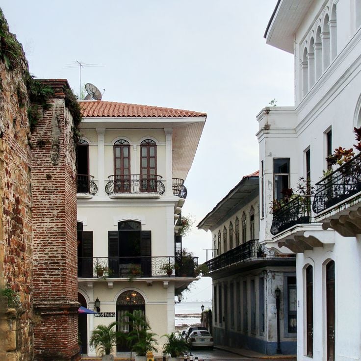
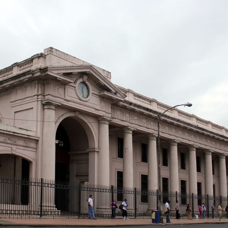
Casco Viejo is the historic center of Panama City, founded in 1673 after the original city was destroyed by pirates. The district features colonial and republican architecture, with restored buildings dating from the 17th to 19th centuries. Cobblestone streets lead to plazas, churches with baroque facades, and buildings showing French and Spanish influences. The area was designated a UNESCO World Heritage Site in 1997.
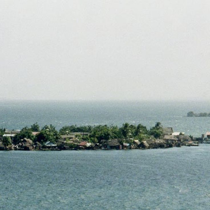
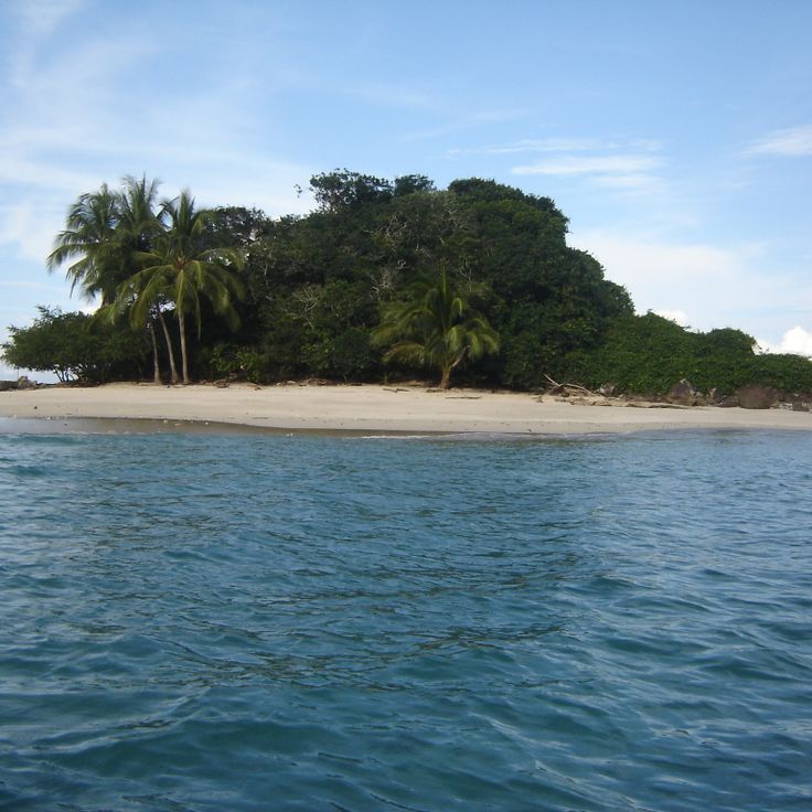
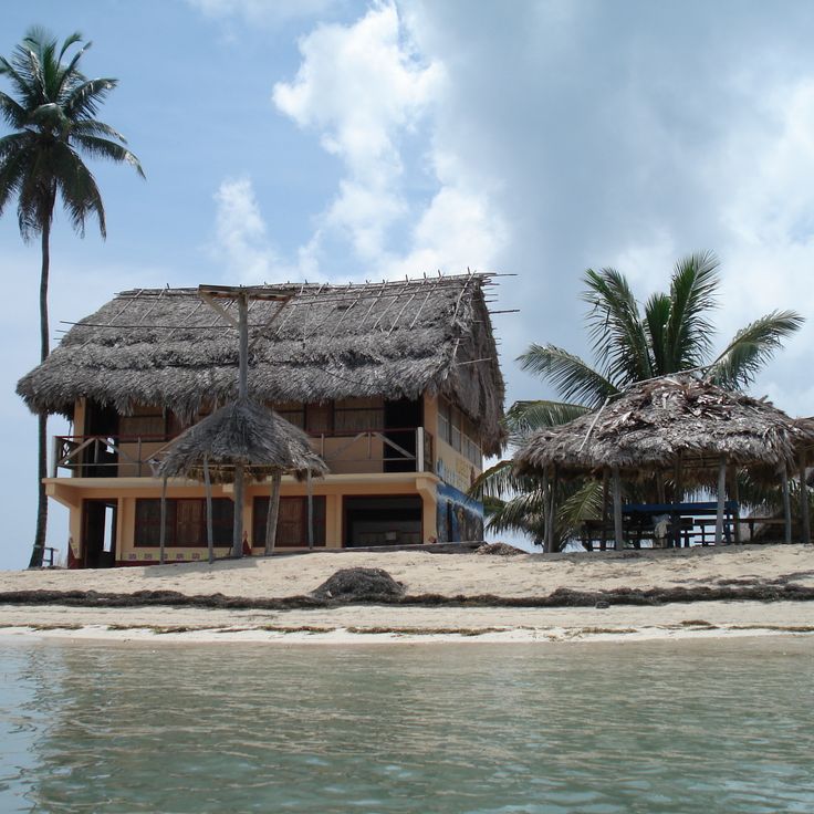
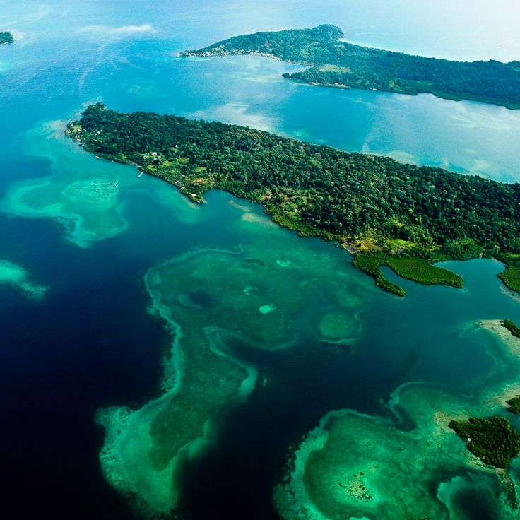
The San Blas Islands form an archipelago of over 365 islands and atolls along Panama's Caribbean coast. These islands are managed by the indigenous Guna people and feature turquoise waters, white sand beaches, and coral reefs. The area provides insight into traditional Guna community life, while limited tourist development has maintained the natural character of the landscape.
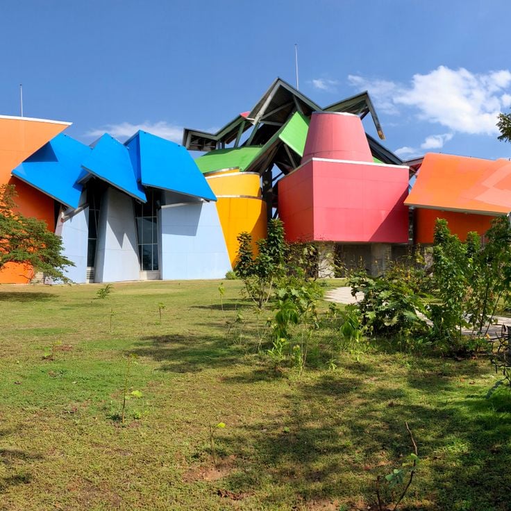
The Biomuseo was designed by architect Frank Gehry and focuses on Panama's biological diversity. The building features colorful geometric forms and multicolored metal roofs. Eight exhibition galleries document the formation of the land bridge between North and South America and its impact on global biodiversity. The museum sits on the Amador Causeway at the Pacific entrance to the Panama Canal.
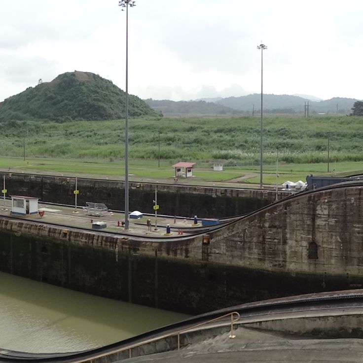
The Miraflores Locks form a central section of the Panama Canal, enabling cargo ships and cruise vessels to transit between the Pacific Ocean and Gatún Lake. This engineering facility consists of two lock chambers that raise or lower ships by approximately 16 meters. The visitor center provides observation platforms from which the lock operation and ship passage can be watched. A museum documents the history of canal construction and explains the hydraulic system of the locks.
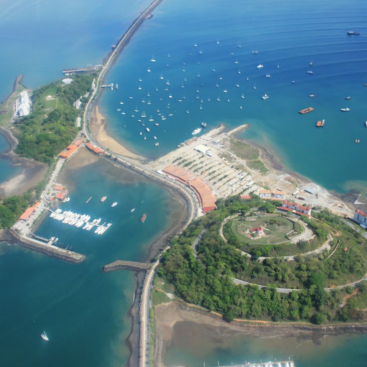
The Amador Causeway is a 6-kilometer road connecting three islands at the Pacific entrance of the Panama Canal. This artificial causeway was constructed using rock excavated during the canal's construction. It provides views of Panama City's skyline, the Bridge of the Americas, and ships entering and leaving the canal. The route links the islands of Naos, Perico, and Flamenco, featuring restaurants, cycling paths, marinas, and the Biodiversity Museum.
Cinta Costera stretches along the coastline of Panama City, offering several kilometers of paved paths for pedestrians and cyclists. This waterfront promenade connects different neighborhoods and provides views of the capital's skyline and the entrance to the Panama Canal. Along the route, visitors find green spaces, sports facilities, and playgrounds. The promenade serves as a recreational space for residents and visitors, particularly in the early morning and evening when temperatures are more comfortable.
The Panama Canal Museum occupies a restored building in the historic Casco Viejo district. Exhibitions document the French and American construction phases of the canal and its effects on international trade. The museum displays historical photographs, technical models and artifacts from the construction period. Visitors learn about the geological challenges, working conditions and political negotiations that led to the canal's completion. Upper floors provide views of the old town and the canal entrance.
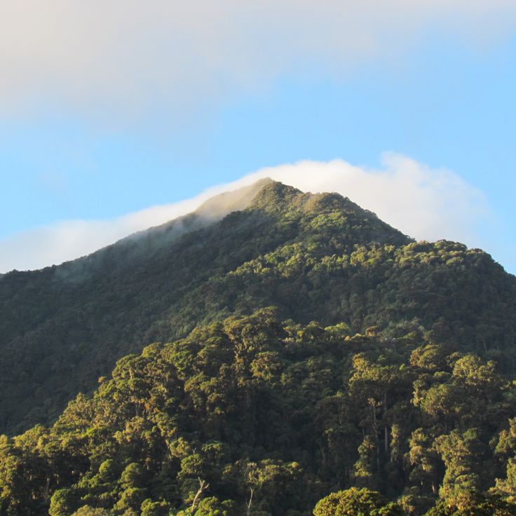
Baru Volcano rises to 3,475 meters above sea level and stands as the highest point in Panama. This dormant stratovolcano offers several hiking trails that pass through cloud forests and alpine vegetation. On clear days, hikers can view both the Pacific Ocean and the Caribbean Sea from the summit. The national park protects numerous bird species and diverse flora that changes with elevation.
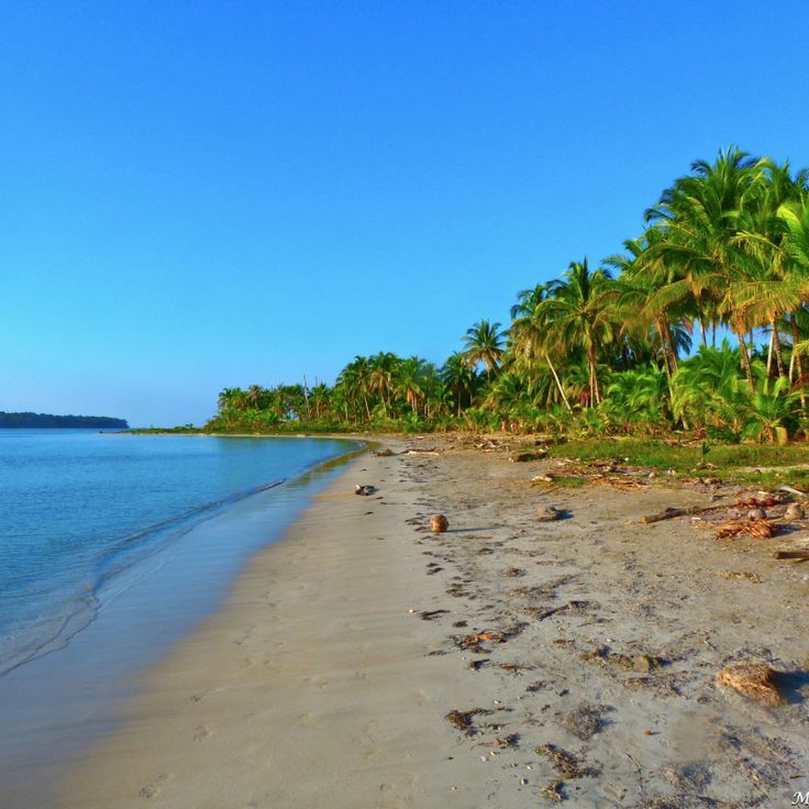
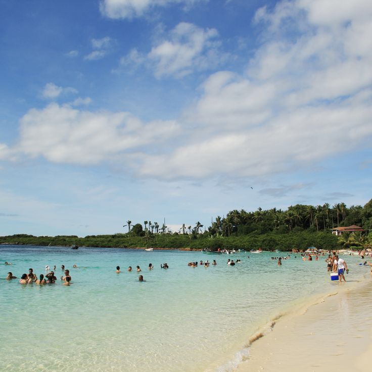
Starfish Beach is located on Isla Colón and attracts visitors with its clear, shallow waters populated by numerous orange starfish. This beach offers calm conditions for snorkeling and allows observation of marine life in their natural habitat. The area is lined with palm trees and features several local restaurants serving Caribbean cuisine.
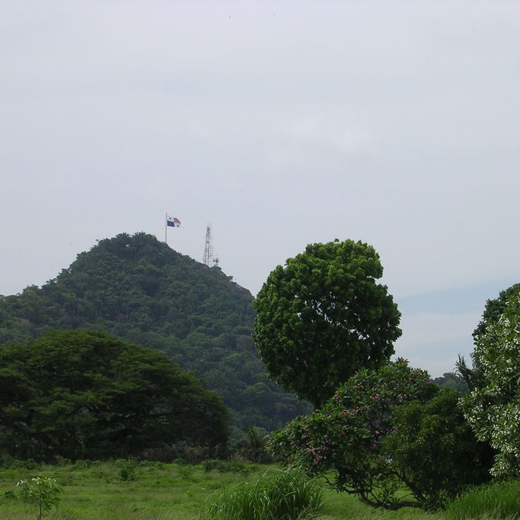
Ancon Hill rises to 199 meters at the edge of Panama City, marking the boundary between the modern metropolis and the Panama Canal. This forested elevation contains a nature reserve with tropical vegetation, home to over 200 bird species. From its summit, the hill provides direct views of the city's skyscrapers, the canal's lock systems, and the Pacific coastline. A paved road leads to the viewpoint where the Panamanian flag flies.
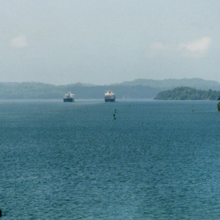
Gatun Lake was created in 1913 by damming the Chagres River and forms a central section of the Panama Canal. This artificial lake covers 425 square kilometers and supplies the canal locks with the water necessary for ship operations. The flooded forest areas have become a habitat for crocodiles, turtles, monkeys, and numerous bird species. The lake offers views of forested islands and passing container ships.
Bocas Town sits on Colón Island and serves as the capital of Bocas del Toro Province. This waterfront settlement features wooden buildings on stilts constructed along the shoreline. The structures display bright colors including red, yellow, green, and blue paint. Numerous restaurants, shops, and guesthouses occupy the renovated buildings from the banana boom era. The town functions as a departure point for boat trips to surrounding islands and diving sites.
Coiba National Park encompasses Coiba Island and several smaller islands in the Pacific Ocean. This marine protected area contains extensive coral reefs, tropical rainforests, and numerous endemic species. The waters provide divers with access to diverse marine life including whale sharks, manta rays, and sea turtles. The remote beaches and clear waters make this location a significant destination for nature observation and underwater photography.
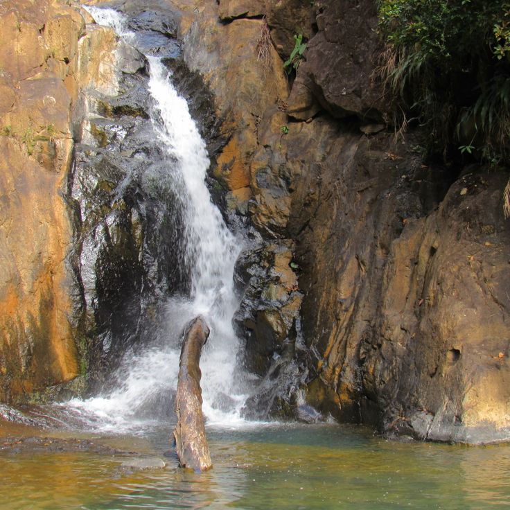
El Valle de Anton sits within an extinct volcanic crater and offers dense tropical forests, multiple waterfalls, and diverse wildlife. The area is known for its natural hot springs, hiking trails through cloud forests, and opportunities to observe rare frog species. The village itself serves as a base for exploring the surrounding natural landscapes and geological formations.
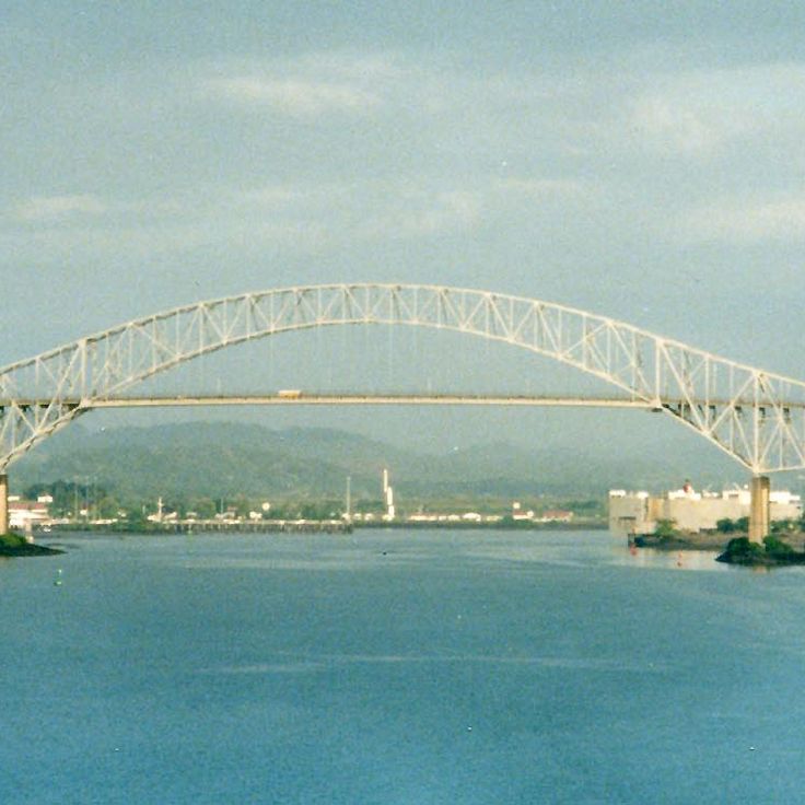
This bridge spans the Pacific entrance to the Panama Canal, connecting North and South America via the Pan-American Highway. Inaugurated in 1962, the structure extends 1,654 meters and rises 117 meters above the water. The construction allows large vessels to pass through the canal below. From various viewpoints in Panama City, the bridge offers views of maritime traffic and the Bay of Panama.
Taboga Island sits approximately 20 kilometers off the coast of Panama City in the Pacific Ocean. This small island offers colonial charm through its 16th-century church and historic buildings in its village center. The island's beaches provide swimming opportunities, while its forested hills contain walking trails for nature enthusiasts. Taboga serves as a quiet retreat from the capital and can be reached by ferry in about one hour.
Metropolitan Natural Park covers 265 hectares of tropical forest within Panama City. This protected area features marked hiking trails that wind through dense woodland, along with observation points offering views of the city and Panama Canal. The reserve records over 227 bird species, including toucans, parrots, and raptors. Mammals such as two-toed sloths, white-faced capuchins, and agoutis inhabit this urban forest. The trails vary in difficulty and length, with some leading to elevated platforms suitable for wildlife observation.
Santa Catalina Beach stretches along the Pacific coast of Veraguas Province and is characterized by its volcanic black sand. Water temperatures remain around 27°C throughout the year. The consistent waves attract surfers from various countries, particularly between December and April when offshore winds optimize conditions for water sports. The coastline provides access to several surf spots with varying difficulty levels.
Chiriquí Gulf Marine National Park covers 14,740 hectares in the Pacific Ocean and includes 25 islands and islets. The protected area contains extensive coral reefs, mangrove forests and numerous fish species. The park waters provide habitat for sea turtles, dolphins and humpback whales during their migration. The islands feature white sand beaches, volcanic rock formations and tropical vegetation. The area is located off the coast of Chiriquí Province in western Panama.
The Pearl Islands form an archipelago of over 200 islands located in the Gulf of Panama. These islands gained economic importance during the 16th century through pearl harvesting operations. Today, the islands offer numerous beaches with white sand and clear waters. The surrounding waters host various marine species, including tropical fish, rays, and sea turtles. Several islands feature small settlements and tourism facilities. The archipelago is accessible by boat or plane from Panama City.
The Isla Iguana Natural Reserve protects a small island and surrounding waters off the coast of the Azuero Peninsula. Coral reefs attract numerous tropical fish species and provide suitable conditions for snorkeling. During breeding season, frigatebirds nest in the island's mangrove forests. Beaches of light-colored sand are lined with palm trees and other tropical plants, while sea turtles regularly come ashore to lay eggs.
The Guna Yala Coast stretches along Panama's Caribbean shoreline and encompasses an autonomous territory administered by the indigenous Guna people. The archipelago consists of approximately 365 coral islands, with around fifty inhabited. The Guna maintain their traditional way of life, including the creation of mola textiles decorated with geometric patterns and reverse appliqué techniques. The coastal waters provide access to coral reefs and turquoise lagoons. Villages consist of bamboo huts with thatched roofs and follow the community's collective organization.
Contadora Island is located in the Pearl Islands archipelago and covers an area of approximately 1.2 square kilometers. The island features eleven sandy beaches along its coastline, including Playa Cacique, Playa Galeón, and Playa Larga. Several hotels and vacation rentals operate on the island to accommodate visitors. Between July and October, humpback whales can be observed in the surrounding waters as they migrate to the region for mating and calving. Contadora is accessible by airplane from the mainland in about 20 minutes or by boat.
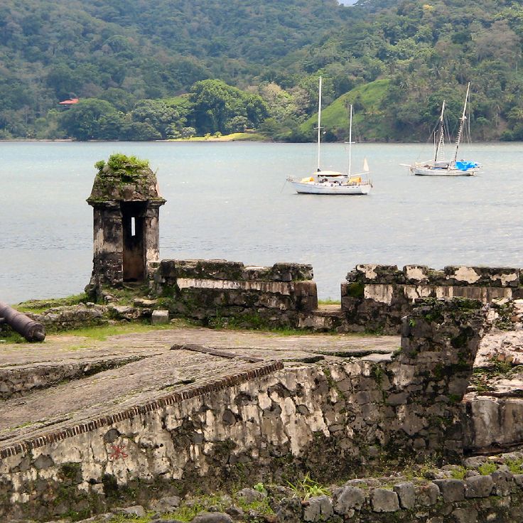
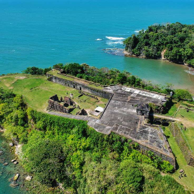
This historic harbor on the Caribbean coast preserves the military architecture of the Spanish colonial period. Fort Santiago displays original bronze and iron cannons along with massive stone walls that illustrate the strategic value of this trading post. The ruins of the royal customs house and other 16th-century fortifications document the importance of Portobelo as a transshipment point for treasures from Peru bound for Spain.
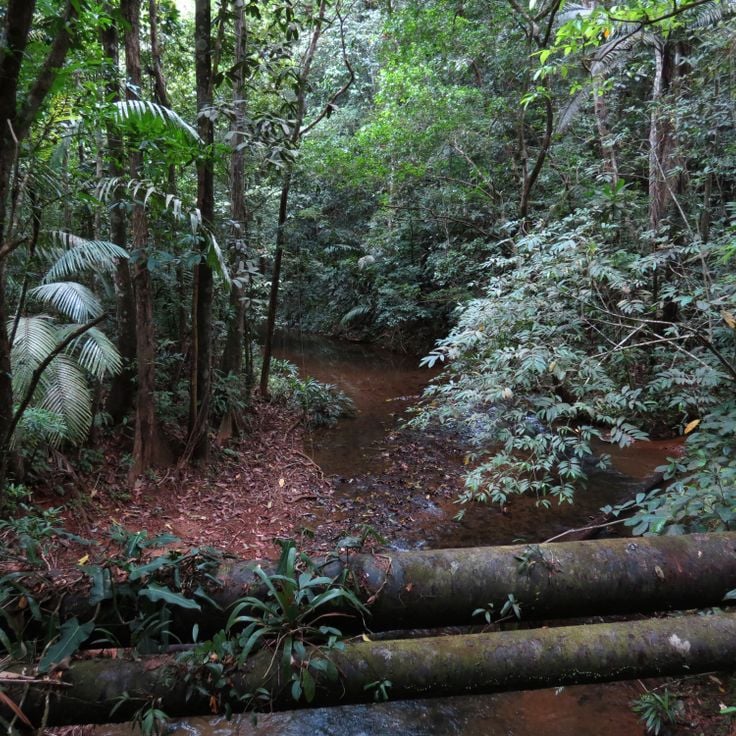
Camino de Cruces National Park protects a section of the colonial cobblestone trail that the Spanish built in the 16th century to transport gold and goods between Panama City and the Caribbean coast. This historic path now crosses dense tropical rainforest that shelters numerous bird species, monkeys, sloths, and reptiles. The hiking trails partly follow the original colonial stone pavement and lead through thick vegetation with towering trees and lianas.
Bastimentos Island National Marine Park covers sections of the island and includes tropical forests as well as coastal mangroves. This protected area is home to sea turtles that nest on the beaches, dolphins, and coral reef formations. Forest trails lead to beaches such as Red Frog Beach, named after the small red frogs that inhabit the region. The underwater environment offers snorkeling opportunities among corals and tropical fish. The park is located in the Bocas del Toro archipelago on Panama's Caribbean coast.
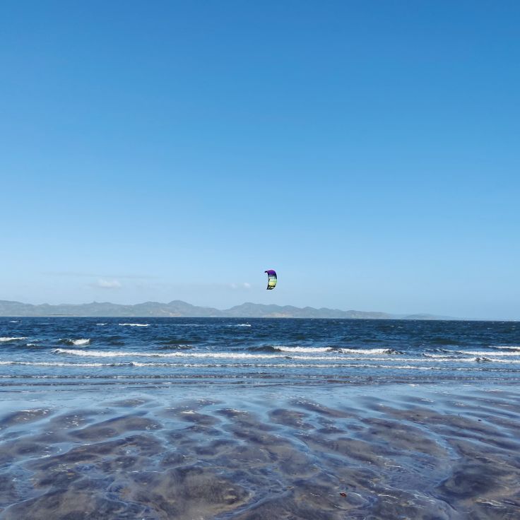
Punta Chame is a narrow peninsula extending approximately 14 kilometers into the Pacific Ocean. The consistent winds and shallow waters make this location a center for kitesurfing and windsurfing. The beaches feature dark volcanic sand and calm areas for swimming. Fishermen depart daily from small ports along the coast. Several surf schools and equipment rental establishments accommodate beginners and experienced practitioners. The surrounding mangroves shelter various bird species. Restaurants along the coastal road serve fresh fish and seafood.
Fort San Lorenzo stands at the mouth of the Chagres River where it meets the Caribbean Sea, built by the Spanish in the 16th century to protect trade routes to Panama City. The fortress was repeatedly attacked and destroyed by pirates, including Henry Morgan in 1671. The ruins display massive stone walls, watchtowers, and cannons pointed toward the sea. The location provides expansive views over the river mouth and the Caribbean coastline. Fort San Lorenzo has been a UNESCO World Heritage Site since 1980 and sits within tropical vegetation in the present-day San Lorenzo National Park.
Cerro Azul sits in the mountains east of Panama City at an elevation of approximately 800 to 1000 meters. This region offers cooler temperatures than coastal areas and features dense cloud forests with numerous hiking trails. The area was originally developed as a summer retreat for city residents and contains colonial-style country houses. Cerro Azul provides opportunities to observe various bird species and tropical plants along its forest paths.
Parque Nacional Soberania spans 22,000 hectares of tropical rainforest along the Panama Canal and hosts over 525 bird species. The Pipeline Road trail is recognized as one of the premier birdwatching locations in the Americas. This protected area includes several hiking trails through dense forest where visitors can observe capuchin monkeys, sloths, agoutis, and toucans. Located just 25 kilometers from Panama City, the park protects an important section of the biological corridor connecting North and South America.
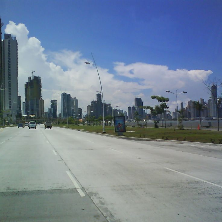
Avenida Balboa runs along the waterfront of Panama City, connecting the historic district of Casco Viejo with the modern neighborhoods. This multilane avenue offers direct views of the city's skyscrapers and the Pacific Ocean. Along the avenue, visitors find parks, monuments, and pedestrian paths suitable for walking. The road serves as a major traffic artery and a popular spot for joggers and cyclists, particularly during early mornings and evenings.
Playa Venao is a Pacific coast beach known for its consistent waves that attract surfers from various regions. The shoreline extends for several kilometers and provides conditions suitable for both beginners and experienced surfers. The beach sits in a rural area with access to local accommodations and surf schools. National and international surf competitions take place here annually. The area features black volcanic sand and is lined with palm trees.
Casco Viejo is the historic center of Panama City, founded in 1673 after the original city was destroyed by pirates. The district features colonial and republican architecture, with restored buildings dating from the 17th to 19th centuries. Cobblestone streets lead to plazas, churches with baroque facades, and buildings showing French and Spanish influences. The area was designated a UNESCO World Heritage Site in 1997.
The San Blas Islands form an archipelago of over 365 islands and atolls along Panama's Caribbean coast. These islands are managed by the indigenous Guna people and feature turquoise waters, white sand beaches, and coral reefs. The area provides insight into traditional Guna community life, while limited tourist development has maintained the natural character of the landscape.
The Biomuseo was designed by architect Frank Gehry and focuses on Panama's biological diversity. The building features colorful geometric forms and multicolored metal roofs. Eight exhibition galleries document the formation of the land bridge between North and South America and its impact on global biodiversity. The museum sits on the Amador Causeway at the Pacific entrance to the Panama Canal.
The Miraflores Locks form a central section of the Panama Canal, enabling cargo ships and cruise vessels to transit between the Pacific Ocean and Gatún Lake. This engineering facility consists of two lock chambers that raise or lower ships by approximately 16 meters. The visitor center provides observation platforms from which the lock operation and ship passage can be watched. A museum documents the history of canal construction and explains the hydraulic system of the locks.
The Amador Causeway is a 6-kilometer road connecting three islands at the Pacific entrance of the Panama Canal. This artificial causeway was constructed using rock excavated during the canal's construction. It provides views of Panama City's skyline, the Bridge of the Americas, and ships entering and leaving the canal. The route links the islands of Naos, Perico, and Flamenco, featuring restaurants, cycling paths, marinas, and the Biodiversity Museum.
Cinta Costera stretches along the coastline of Panama City, offering several kilometers of paved paths for pedestrians and cyclists. This waterfront promenade connects different neighborhoods and provides views of the capital's skyline and the entrance to the Panama Canal. Along the route, visitors find green spaces, sports facilities, and playgrounds. The promenade serves as a recreational space for residents and visitors, particularly in the early morning and evening when temperatures are more comfortable.
The Panama Canal Museum occupies a restored building in the historic Casco Viejo district. Exhibitions document the French and American construction phases of the canal and its effects on international trade. The museum displays historical photographs, technical models and artifacts from the construction period. Visitors learn about the geological challenges, working conditions and political negotiations that led to the canal's completion. Upper floors provide views of the old town and the canal entrance.
Baru Volcano rises to 3,475 meters above sea level and stands as the highest point in Panama. This dormant stratovolcano offers several hiking trails that pass through cloud forests and alpine vegetation. On clear days, hikers can view both the Pacific Ocean and the Caribbean Sea from the summit. The national park protects numerous bird species and diverse flora that changes with elevation.
Starfish Beach is located on Isla Colón and attracts visitors with its clear, shallow waters populated by numerous orange starfish. This beach offers calm conditions for snorkeling and allows observation of marine life in their natural habitat. The area is lined with palm trees and features several local restaurants serving Caribbean cuisine.
Ancon Hill rises to 199 meters at the edge of Panama City, marking the boundary between the modern metropolis and the Panama Canal. This forested elevation contains a nature reserve with tropical vegetation, home to over 200 bird species. From its summit, the hill provides direct views of the city's skyscrapers, the canal's lock systems, and the Pacific coastline. A paved road leads to the viewpoint where the Panamanian flag flies.
Gatun Lake was created in 1913 by damming the Chagres River and forms a central section of the Panama Canal. This artificial lake covers 425 square kilometers and supplies the canal locks with the water necessary for ship operations. The flooded forest areas have become a habitat for crocodiles, turtles, monkeys, and numerous bird species. The lake offers views of forested islands and passing container ships.
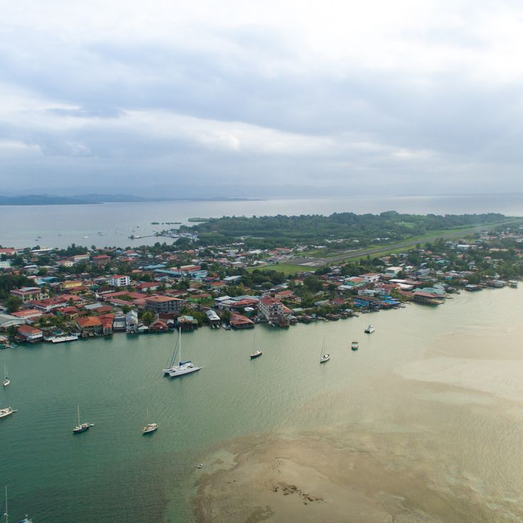
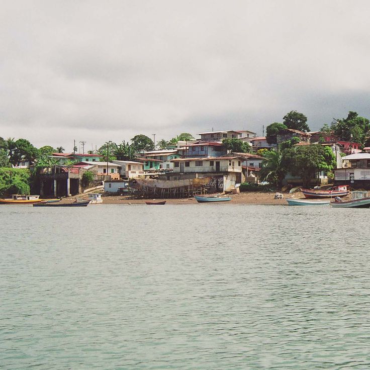
Bocas Town sits on Colón Island and serves as the capital of Bocas del Toro Province. This waterfront settlement features wooden buildings on stilts constructed along the shoreline. The structures display bright colors including red, yellow, green, and blue paint. Numerous restaurants, shops, and guesthouses occupy the renovated buildings from the banana boom era. The town functions as a departure point for boat trips to surrounding islands and diving sites.
Coiba National Park encompasses Coiba Island and several smaller islands in the Pacific Ocean. This marine protected area contains extensive coral reefs, tropical rainforests, and numerous endemic species. The waters provide divers with access to diverse marine life including whale sharks, manta rays, and sea turtles. The remote beaches and clear waters make this location a significant destination for nature observation and underwater photography.
El Valle de Anton sits within an extinct volcanic crater and offers dense tropical forests, multiple waterfalls, and diverse wildlife. The area is known for its natural hot springs, hiking trails through cloud forests, and opportunities to observe rare frog species. The village itself serves as a base for exploring the surrounding natural landscapes and geological formations.
This bridge spans the Pacific entrance to the Panama Canal, connecting North and South America via the Pan-American Highway. Inaugurated in 1962, the structure extends 1,654 meters and rises 117 meters above the water. The construction allows large vessels to pass through the canal below. From various viewpoints in Panama City, the bridge offers views of maritime traffic and the Bay of Panama.
Taboga Island sits approximately 20 kilometers off the coast of Panama City in the Pacific Ocean. This small island offers colonial charm through its 16th-century church and historic buildings in its village center. The island's beaches provide swimming opportunities, while its forested hills contain walking trails for nature enthusiasts. Taboga serves as a quiet retreat from the capital and can be reached by ferry in about one hour.
Metropolitan Natural Park covers 265 hectares of tropical forest within Panama City. This protected area features marked hiking trails that wind through dense woodland, along with observation points offering views of the city and Panama Canal. The reserve records over 227 bird species, including toucans, parrots, and raptors. Mammals such as two-toed sloths, white-faced capuchins, and agoutis inhabit this urban forest. The trails vary in difficulty and length, with some leading to elevated platforms suitable for wildlife observation.
Santa Catalina Beach stretches along the Pacific coast of Veraguas Province and is characterized by its volcanic black sand. Water temperatures remain around 27°C throughout the year. The consistent waves attract surfers from various countries, particularly between December and April when offshore winds optimize conditions for water sports. The coastline provides access to several surf spots with varying difficulty levels.
Chiriquí Gulf Marine National Park covers 14,740 hectares in the Pacific Ocean and includes 25 islands and islets. The protected area contains extensive coral reefs, mangrove forests and numerous fish species. The park waters provide habitat for sea turtles, dolphins and humpback whales during their migration. The islands feature white sand beaches, volcanic rock formations and tropical vegetation. The area is located off the coast of Chiriquí Province in western Panama.
The Pearl Islands form an archipelago of over 200 islands located in the Gulf of Panama. These islands gained economic importance during the 16th century through pearl harvesting operations. Today, the islands offer numerous beaches with white sand and clear waters. The surrounding waters host various marine species, including tropical fish, rays, and sea turtles. Several islands feature small settlements and tourism facilities. The archipelago is accessible by boat or plane from Panama City.
The Isla Iguana Natural Reserve protects a small island and surrounding waters off the coast of the Azuero Peninsula. Coral reefs attract numerous tropical fish species and provide suitable conditions for snorkeling. During breeding season, frigatebirds nest in the island's mangrove forests. Beaches of light-colored sand are lined with palm trees and other tropical plants, while sea turtles regularly come ashore to lay eggs.
The Guna Yala Coast stretches along Panama's Caribbean shoreline and encompasses an autonomous territory administered by the indigenous Guna people. The archipelago consists of approximately 365 coral islands, with around fifty inhabited. The Guna maintain their traditional way of life, including the creation of mola textiles decorated with geometric patterns and reverse appliqué techniques. The coastal waters provide access to coral reefs and turquoise lagoons. Villages consist of bamboo huts with thatched roofs and follow the community's collective organization.
Contadora Island is located in the Pearl Islands archipelago and covers an area of approximately 1.2 square kilometers. The island features eleven sandy beaches along its coastline, including Playa Cacique, Playa Galeón, and Playa Larga. Several hotels and vacation rentals operate on the island to accommodate visitors. Between July and October, humpback whales can be observed in the surrounding waters as they migrate to the region for mating and calving. Contadora is accessible by airplane from the mainland in about 20 minutes or by boat.
This historic harbor on the Caribbean coast preserves the military architecture of the Spanish colonial period. Fort Santiago displays original bronze and iron cannons along with massive stone walls that illustrate the strategic value of this trading post. The ruins of the royal customs house and other 16th-century fortifications document the importance of Portobelo as a transshipment point for treasures from Peru bound for Spain.
Camino de Cruces National Park protects a section of the colonial cobblestone trail that the Spanish built in the 16th century to transport gold and goods between Panama City and the Caribbean coast. This historic path now crosses dense tropical rainforest that shelters numerous bird species, monkeys, sloths, and reptiles. The hiking trails partly follow the original colonial stone pavement and lead through thick vegetation with towering trees and lianas.
Bastimentos Island National Marine Park covers sections of the island and includes tropical forests as well as coastal mangroves. This protected area is home to sea turtles that nest on the beaches, dolphins, and coral reef formations. Forest trails lead to beaches such as Red Frog Beach, named after the small red frogs that inhabit the region. The underwater environment offers snorkeling opportunities among corals and tropical fish. The park is located in the Bocas del Toro archipelago on Panama's Caribbean coast.
Punta Chame is a narrow peninsula extending approximately 14 kilometers into the Pacific Ocean. The consistent winds and shallow waters make this location a center for kitesurfing and windsurfing. The beaches feature dark volcanic sand and calm areas for swimming. Fishermen depart daily from small ports along the coast. Several surf schools and equipment rental establishments accommodate beginners and experienced practitioners. The surrounding mangroves shelter various bird species. Restaurants along the coastal road serve fresh fish and seafood.
Fort San Lorenzo stands at the mouth of the Chagres River where it meets the Caribbean Sea, built by the Spanish in the 16th century to protect trade routes to Panama City. The fortress was repeatedly attacked and destroyed by pirates, including Henry Morgan in 1671. The ruins display massive stone walls, watchtowers, and cannons pointed toward the sea. The location provides expansive views over the river mouth and the Caribbean coastline. Fort San Lorenzo has been a UNESCO World Heritage Site since 1980 and sits within tropical vegetation in the present-day San Lorenzo National Park.
Cerro Azul sits in the mountains east of Panama City at an elevation of approximately 800 to 1000 meters. This region offers cooler temperatures than coastal areas and features dense cloud forests with numerous hiking trails. The area was originally developed as a summer retreat for city residents and contains colonial-style country houses. Cerro Azul provides opportunities to observe various bird species and tropical plants along its forest paths.
Parque Nacional Soberania spans 22,000 hectares of tropical rainforest along the Panama Canal and hosts over 525 bird species. The Pipeline Road trail is recognized as one of the premier birdwatching locations in the Americas. This protected area includes several hiking trails through dense forest where visitors can observe capuchin monkeys, sloths, agoutis, and toucans. Located just 25 kilometers from Panama City, the park protects an important section of the biological corridor connecting North and South America.
Avenida Balboa runs along the waterfront of Panama City, connecting the historic district of Casco Viejo with the modern neighborhoods. This multilane avenue offers direct views of the city's skyscrapers and the Pacific Ocean. Along the avenue, visitors find parks, monuments, and pedestrian paths suitable for walking. The road serves as a major traffic artery and a popular spot for joggers and cyclists, particularly during early mornings and evenings.
Playa Venao is a Pacific coast beach known for its consistent waves that attract surfers from various regions. The shoreline extends for several kilometers and provides conditions suitable for both beginners and experienced surfers. The beach sits in a rural area with access to local accommodations and surf schools. National and international surf competitions take place here annually. The area features black volcanic sand and is lined with palm trees.
Casco Viejo is the historic center of Panama City, founded in 1673 after the original city was destroyed by pirates. The district features colonial and republican architecture, with restored buildings dating from the 17th to 19th centuries. Cobblestone streets lead to plazas, churches with baroque facades, and buildings showing French and Spanish influences. The area was designated a UNESCO World Heritage Site in 1997.
The San Blas Islands form an archipelago of over 365 islands and atolls along Panama's Caribbean coast. These islands are managed by the indigenous Guna people and feature turquoise waters, white sand beaches, and coral reefs. The area provides insight into traditional Guna community life, while limited tourist development has maintained the natural character of the landscape.
The Biomuseo was designed by architect Frank Gehry and focuses on Panama's biological diversity. The building features colorful geometric forms and multicolored metal roofs. Eight exhibition galleries document the formation of the land bridge between North and South America and its impact on global biodiversity. The museum sits on the Amador Causeway at the Pacific entrance to the Panama Canal.
The Miraflores Locks form a central section of the Panama Canal, enabling cargo ships and cruise vessels to transit between the Pacific Ocean and Gatún Lake. This engineering facility consists of two lock chambers that raise or lower ships by approximately 16 meters. The visitor center provides observation platforms from which the lock operation and ship passage can be watched. A museum documents the history of canal construction and explains the hydraulic system of the locks.
The Amador Causeway is a 6-kilometer road connecting three islands at the Pacific entrance of the Panama Canal. This artificial causeway was constructed using rock excavated during the canal's construction. It provides views of Panama City's skyline, the Bridge of the Americas, and ships entering and leaving the canal. The route links the islands of Naos, Perico, and Flamenco, featuring restaurants, cycling paths, marinas, and the Biodiversity Museum.
Cinta Costera stretches along the coastline of Panama City, offering several kilometers of paved paths for pedestrians and cyclists. This waterfront promenade connects different neighborhoods and provides views of the capital's skyline and the entrance to the Panama Canal. Along the route, visitors find green spaces, sports facilities, and playgrounds. The promenade serves as a recreational space for residents and visitors, particularly in the early morning and evening when temperatures are more comfortable.
The Panama Canal Museum occupies a restored building in the historic Casco Viejo district. Exhibitions document the French and American construction phases of the canal and its effects on international trade. The museum displays historical photographs, technical models and artifacts from the construction period. Visitors learn about the geological challenges, working conditions and political negotiations that led to the canal's completion. Upper floors provide views of the old town and the canal entrance.
Baru Volcano rises to 3,475 meters above sea level and stands as the highest point in Panama. This dormant stratovolcano offers several hiking trails that pass through cloud forests and alpine vegetation. On clear days, hikers can view both the Pacific Ocean and the Caribbean Sea from the summit. The national park protects numerous bird species and diverse flora that changes with elevation.
Starfish Beach is located on Isla Colón and attracts visitors with its clear, shallow waters populated by numerous orange starfish. This beach offers calm conditions for snorkeling and allows observation of marine life in their natural habitat. The area is lined with palm trees and features several local restaurants serving Caribbean cuisine.
Ancon Hill rises to 199 meters at the edge of Panama City, marking the boundary between the modern metropolis and the Panama Canal. This forested elevation contains a nature reserve with tropical vegetation, home to over 200 bird species. From its summit, the hill provides direct views of the city's skyscrapers, the canal's lock systems, and the Pacific coastline. A paved road leads to the viewpoint where the Panamanian flag flies.
Gatun Lake was created in 1913 by damming the Chagres River and forms a central section of the Panama Canal. This artificial lake covers 425 square kilometers and supplies the canal locks with the water necessary for ship operations. The flooded forest areas have become a habitat for crocodiles, turtles, monkeys, and numerous bird species. The lake offers views of forested islands and passing container ships.
Bocas Town sits on Colón Island and serves as the capital of Bocas del Toro Province. This waterfront settlement features wooden buildings on stilts constructed along the shoreline. The structures display bright colors including red, yellow, green, and blue paint. Numerous restaurants, shops, and guesthouses occupy the renovated buildings from the banana boom era. The town functions as a departure point for boat trips to surrounding islands and diving sites.
Coiba National Park encompasses Coiba Island and several smaller islands in the Pacific Ocean. This marine protected area contains extensive coral reefs, tropical rainforests, and numerous endemic species. The waters provide divers with access to diverse marine life including whale sharks, manta rays, and sea turtles. The remote beaches and clear waters make this location a significant destination for nature observation and underwater photography.
El Valle de Anton sits within an extinct volcanic crater and offers dense tropical forests, multiple waterfalls, and diverse wildlife. The area is known for its natural hot springs, hiking trails through cloud forests, and opportunities to observe rare frog species. The village itself serves as a base for exploring the surrounding natural landscapes and geological formations.
This bridge spans the Pacific entrance to the Panama Canal, connecting North and South America via the Pan-American Highway. Inaugurated in 1962, the structure extends 1,654 meters and rises 117 meters above the water. The construction allows large vessels to pass through the canal below. From various viewpoints in Panama City, the bridge offers views of maritime traffic and the Bay of Panama.
Taboga Island sits approximately 20 kilometers off the coast of Panama City in the Pacific Ocean. This small island offers colonial charm through its 16th-century church and historic buildings in its village center. The island's beaches provide swimming opportunities, while its forested hills contain walking trails for nature enthusiasts. Taboga serves as a quiet retreat from the capital and can be reached by ferry in about one hour.
Metropolitan Natural Park covers 265 hectares of tropical forest within Panama City. This protected area features marked hiking trails that wind through dense woodland, along with observation points offering views of the city and Panama Canal. The reserve records over 227 bird species, including toucans, parrots, and raptors. Mammals such as two-toed sloths, white-faced capuchins, and agoutis inhabit this urban forest. The trails vary in difficulty and length, with some leading to elevated platforms suitable for wildlife observation.
Santa Catalina Beach stretches along the Pacific coast of Veraguas Province and is characterized by its volcanic black sand. Water temperatures remain around 27°C throughout the year. The consistent waves attract surfers from various countries, particularly between December and April when offshore winds optimize conditions for water sports. The coastline provides access to several surf spots with varying difficulty levels.
Chiriquí Gulf Marine National Park covers 14,740 hectares in the Pacific Ocean and includes 25 islands and islets. The protected area contains extensive coral reefs, mangrove forests and numerous fish species. The park waters provide habitat for sea turtles, dolphins and humpback whales during their migration. The islands feature white sand beaches, volcanic rock formations and tropical vegetation. The area is located off the coast of Chiriquí Province in western Panama.
The Pearl Islands form an archipelago of over 200 islands located in the Gulf of Panama. These islands gained economic importance during the 16th century through pearl harvesting operations. Today, the islands offer numerous beaches with white sand and clear waters. The surrounding waters host various marine species, including tropical fish, rays, and sea turtles. Several islands feature small settlements and tourism facilities. The archipelago is accessible by boat or plane from Panama City.
The Isla Iguana Natural Reserve protects a small island and surrounding waters off the coast of the Azuero Peninsula. Coral reefs attract numerous tropical fish species and provide suitable conditions for snorkeling. During breeding season, frigatebirds nest in the island's mangrove forests. Beaches of light-colored sand are lined with palm trees and other tropical plants, while sea turtles regularly come ashore to lay eggs.
The Guna Yala Coast stretches along Panama's Caribbean shoreline and encompasses an autonomous territory administered by the indigenous Guna people. The archipelago consists of approximately 365 coral islands, with around fifty inhabited. The Guna maintain their traditional way of life, including the creation of mola textiles decorated with geometric patterns and reverse appliqué techniques. The coastal waters provide access to coral reefs and turquoise lagoons. Villages consist of bamboo huts with thatched roofs and follow the community's collective organization.
Contadora Island is located in the Pearl Islands archipelago and covers an area of approximately 1.2 square kilometers. The island features eleven sandy beaches along its coastline, including Playa Cacique, Playa Galeón, and Playa Larga. Several hotels and vacation rentals operate on the island to accommodate visitors. Between July and October, humpback whales can be observed in the surrounding waters as they migrate to the region for mating and calving. Contadora is accessible by airplane from the mainland in about 20 minutes or by boat.
This historic harbor on the Caribbean coast preserves the military architecture of the Spanish colonial period. Fort Santiago displays original bronze and iron cannons along with massive stone walls that illustrate the strategic value of this trading post. The ruins of the royal customs house and other 16th-century fortifications document the importance of Portobelo as a transshipment point for treasures from Peru bound for Spain.
Camino de Cruces National Park protects a section of the colonial cobblestone trail that the Spanish built in the 16th century to transport gold and goods between Panama City and the Caribbean coast. This historic path now crosses dense tropical rainforest that shelters numerous bird species, monkeys, sloths, and reptiles. The hiking trails partly follow the original colonial stone pavement and lead through thick vegetation with towering trees and lianas.
Bastimentos Island National Marine Park covers sections of the island and includes tropical forests as well as coastal mangroves. This protected area is home to sea turtles that nest on the beaches, dolphins, and coral reef formations. Forest trails lead to beaches such as Red Frog Beach, named after the small red frogs that inhabit the region. The underwater environment offers snorkeling opportunities among corals and tropical fish. The park is located in the Bocas del Toro archipelago on Panama's Caribbean coast.
Punta Chame is a narrow peninsula extending approximately 14 kilometers into the Pacific Ocean. The consistent winds and shallow waters make this location a center for kitesurfing and windsurfing. The beaches feature dark volcanic sand and calm areas for swimming. Fishermen depart daily from small ports along the coast. Several surf schools and equipment rental establishments accommodate beginners and experienced practitioners. The surrounding mangroves shelter various bird species. Restaurants along the coastal road serve fresh fish and seafood.
Fort San Lorenzo stands at the mouth of the Chagres River where it meets the Caribbean Sea, built by the Spanish in the 16th century to protect trade routes to Panama City. The fortress was repeatedly attacked and destroyed by pirates, including Henry Morgan in 1671. The ruins display massive stone walls, watchtowers, and cannons pointed toward the sea. The location provides expansive views over the river mouth and the Caribbean coastline. Fort San Lorenzo has been a UNESCO World Heritage Site since 1980 and sits within tropical vegetation in the present-day San Lorenzo National Park.
Cerro Azul sits in the mountains east of Panama City at an elevation of approximately 800 to 1000 meters. This region offers cooler temperatures than coastal areas and features dense cloud forests with numerous hiking trails. The area was originally developed as a summer retreat for city residents and contains colonial-style country houses. Cerro Azul provides opportunities to observe various bird species and tropical plants along its forest paths.
Parque Nacional Soberania spans 22,000 hectares of tropical rainforest along the Panama Canal and hosts over 525 bird species. The Pipeline Road trail is recognized as one of the premier birdwatching locations in the Americas. This protected area includes several hiking trails through dense forest where visitors can observe capuchin monkeys, sloths, agoutis, and toucans. Located just 25 kilometers from Panama City, the park protects an important section of the biological corridor connecting North and South America.
Avenida Balboa runs along the waterfront of Panama City, connecting the historic district of Casco Viejo with the modern neighborhoods. This multilane avenue offers direct views of the city's skyscrapers and the Pacific Ocean. Along the avenue, visitors find parks, monuments, and pedestrian paths suitable for walking. The road serves as a major traffic artery and a popular spot for joggers and cyclists, particularly during early mornings and evenings.
Playa Venao is a Pacific coast beach known for its consistent waves that attract surfers from various regions. The shoreline extends for several kilometers and provides conditions suitable for both beginners and experienced surfers. The beach sits in a rural area with access to local accommodations and surf schools. National and international surf competitions take place here annually. The area features black volcanic sand and is lined with palm trees.
Plan your trips according to the rainy season, which makes some roads hard to access and changes the scenery. coastal roads are usually still passable, while mountain trails can be slippery. Check local conditions before going outside main tourist areas.