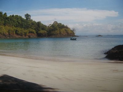
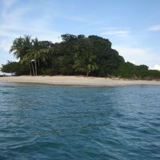
Golfo de Chiriquí National Park, Marine national park on Panama's Pacific coast.
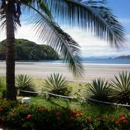
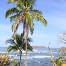
Golfo de Chiriquí National Park is a marine protected area on Panama's Pacific coast covering about 14,740 hectares. The park includes more than two dozen islands surrounded by coral reefs, mangrove forests, and seagrass beds in these coastal waters.
The park was established in 1994 to protect the marine ecosystems of Chiriquí Gulf. This designation created a safe refuge for a wide range of sea creatures in the region.
Local fishing communities have kept their traditional practices while learning to work with conservation rules that protect the marine life here. This balance between old ways and modern protection shapes how people live and work on the water today.
The park is best reached from the town of Horconcitos, located about 40 kilometers east of David. From there, you drive to Boca Chica where boats are available for exploring the islands and reefs.
Between August and October, humpback whales pass through the protected waters during their migration from Antarctica to tropical breeding areas. This seasonal arrival makes the park one of the few places where you can watch these ocean giants along their migration route.
GPS coordinates: 7.32444,-81.80000
Latest update: December 6, 2025 17:41
Panama features a variety of photographic settings, from the colonial district of Casco Viejo to the fine sandy beaches of the San Blas Islands. Panama City combines historic heritage and modern architecture, including Frank Gehry's Biomuseo and the Miraflores locks that showcase canal engineering. Walks such as Cinta Costera or Amador Causeway offer views over the bay and the city skyline. Beyond the city, the country reveals rich and accessible nature. The Baru volcano rises over 3400 meters in Chiriquí province, while the Bocas del Toro archipelago hosts secluded beaches with turquoise waters. Tropical forests, marine reserves, and mountain trails complete this landscape diversity, making Panama a full photographic destination between the Atlantic and Pacific.
La Yeguada
166.2 km
Iglesia de San Francisco de la Montaña
137.3 km
St. James the Apostle Cathedral, Santiago de Veraguas
124.5 km
Saint Dominic Church of Parita
159.8 km
Estadio Kenny Sarracín
142.3 km
Casa Museo Belisario Porras
175 km
Estadio San Cristóbal
141.1 km
Manuel F. Zárate House Museum
176.6 km
Coiba
17.4 km
Lucero Golf Country Club
168.7 km
Santa Catalina Beach
68.8 km
Playa Cambutal
147.6 km
Casa Museo Manuel F. Zárate
176.5 km
Church of Saint Michael
167.3 km
Antigua Estación del Ferrocarril de Bugaba
160.8 km
Traditional architecture of Monagrillo
167.3 km
Iglesia de Santa Librada
175 km
Macho de Monte Cascadas
175.7 km
Catedral San Juan Bautista de Chitré
167.2 km
Plaza de Parita
159.8 km
Catedral de San José de David
140.4 km
Escuela Presidente Porras No.1
175.2 km
Residencia de José de Obaldía
140.5 km
Escuela Normal Juan Demóstenes Arosemena
125.4 km
Playa Las Lajas
95 km
Los Cangilones de Gualaca
146.5 km
Museo de la Nacionalidad
167.4 km
Iglesia de San Atanasio de Los Santos
167.5 kmReviews
Visited this place? Tap the stars to rate it and share your experience / photos with the community! Try now! You can cancel it anytime.
Discover hidden gems everywhere you go!
From secret cafés to breathtaking viewpoints, skip the crowded tourist spots and find places that match your style. Our app makes it easy with voice search, smart filtering, route optimization, and insider tips from travelers worldwide. Download now for the complete mobile experience.
A unique approach to discovering new places❞
— Le Figaro
All the places worth exploring❞
— France Info
A tailor-made excursion in just a few clicks❞
— 20 Minutes