Enable Location

We need your location to show you interesting places around you

Discover nearby places

Find interesting locations and hidden gems around you

Precise directions

Get accurate directions and distances to places

Your location is never shared with other users. It's only used when you tap the location button.

Ciudad Nezahualcóyotl

Log in to your account

Start exploring — it's free

Trusted by 62,865 travelers worldwide

Continue with Google
Continue with Apple
or

We will send you a code to connect

By continuing, you accept our Terms and Conditions and our Privacy Policy

Check your inbox

We've sent a pincode in your inbox. Please enter the code below.

Ciudad Nezahualcóyotl, Municipality in State of Mexico, Mexico

Ciudad Nezahualcóyotl is a municipality in the northeastern section of the Mexico City metropolitan area, built over what was once Lake Texcoco. Its streets form a grid of residential blocks and commercial avenues, with local markets and public plazas scattered throughout the sprawling urban fabric.

Settlement began after 1912 when the government sold plots on land exposed by draining Lake Texcoco. Over several decades, one of the metropolitan area's most densely settled municipalities emerged, named after the 15th-century ruler of Texcoco.

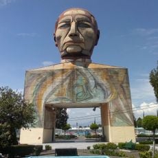
The municipality carries the name of Nezahualcoyotl, the 15th-century Texcoco ruler who established significant legal reforms and contributed to Mesoamerican literature through poetry.

The Mexibus line runs through the municipality and links it to neighboring areas, making travel to central Mexico City straightforward. Several main roads cross the territory, providing continuous connections to surrounding regions.

The former Bordo de Xochiaca landfill was redeveloped into a public park and housing development, illustrating a shift in land use over recent decades. Beneath the current streets lie layers of lake sediment that still recall the area's origins on the Texcoco lakebed.

The community of curious travelers

AroundUs brings together thousands of curated places, local tips, and hidden gems, enriched daily by 60,000 contributors worldwide.

Start exploring
Inception
April 23, 1963
Elevation above the sea
2.98 m
GPS coordinates
19.40061,-99.01483
Latest update
December 15, 2025 04:15
« Ciudad Nezahualcóyotl - Municipality in State of Mexico, Mexico » is provided by Around Us (aroundus.com). Images and texts are derived from Wikimedia project under a Creative Commons license. You are allowed to copy, distribute, and modify copies of this page, under the conditions set by the license, as long as this note is clearly visible.

Discover hidden gems everywhere you go!

From secret cafés to breathtaking viewpoints, skip the crowded tourist spots and find places that match your style. Our app makes it easy with voice search, smart filtering, route optimization, and insider tips from travelers worldwide. Download now for the complete mobile experience.

Around Us App Screenshot

A unique approach to discovering new places

Le Figaro

All the places worth exploring

France Info

A tailor-made excursion in just a few clicks

20 Minutes

Around Us
Travel Guide & Maps
Download

Send to your phone

QR Code
1

Open the camera app on your mobile.

2

Point at the QR code with your camera. A notification will appear.

3

Tap the notification to open the link.