Enable Location

We need your location to show you interesting places around you

Discover nearby places

Find interesting locations and hidden gems around you

Precise directions

Get accurate directions and distances to places

Your location is never shared with other users. It's only used when you tap the location button.

Fannin Battleground State Historic Site

Log in to your account

Start exploring — it's free

Trusted by 61,625 travelers worldwide

Continue with Google
Continue with Apple
or

We will send you a code to connect

By continuing, you accept our Terms and Conditions and our Privacy Policy

Check your inbox

We've sent a pincode in your inbox. Please enter the code below.

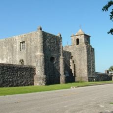
Fannin Battleground State Historic Site, Memorial battlefield in Goliad County, United States.

Description

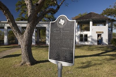
Fannin Battleground State Historic Site is a memorial ground in Goliad County that spans about 14 acres and gives visitors insight into an important moment in Texas history. The location features a stone obelisk, educational exhibits, a covered pavilion for groups, and picnic areas set on landscaped grounds near Highway 59.

History

The grounds commemorate the Battle of Coleto Creek in March 1836, when Colonel James Fannin and his Texian forces fought against the Mexican army under General Urrea. This confrontation was a critical moment in the Texas independence movement and shaped the course of events that followed.

Culture

Local residents made an effort to preserve this land as a way to honor the fallen soldiers and remember their sacrifice. Visitors today experience it as a place where the memory of those who fought here is kept alive through quiet reflection.

Practical

The grounds are open to visitors daily and there are no admission fees. The facilities can be explored freely during daylight hours and offer good opportunities to rest and learn about this location.

Did you know?

An iron cotton gin screw originally stood at the site as the first memorial, placed there in 1891 by a local man named William Hunter. This unusual marker predated the stone obelisk and shows how the place was remembered by ordinary citizens before becoming an official historic site.

Location
Location
Address
734 FM 2506
GPS coordinates
28.68650,-97.23280
Latest update
December 11, 2025 18:07

AroundUs brings together thousands of curated places, local tips, and hidden gems, enriched daily by 60,000 contributors worldwide. Discover all places nearby (Goliad County).

Around this place
Presidio La Bahía
United States of America

Presidio La Bahía

15.3 km
Zaragoza Birthplace State Historic Site
United States of America

Zaragoza Birthplace State Historic Site

15.2 km
Fossati's Delicatessen
United States of America

Fossati's Delicatessen

25.3 km
Riverside Stadium
United States of America

Riverside Stadium

24.8 km
Victoria Colored School
United States of America

Victoria Colored School

25.6 km
DeLeon Plaza and Bandstand
United States of America

DeLeon Plaza and Bandstand

25.4 km
Saint Mary's Catholic Church
United States of America

Saint Mary's Catholic Church

25.2 km
Thomas M. O'Connor House
United States of America

Thomas M. O'Connor House

25.2 km
Our Lady of Lourdes Church
United States of America

Our Lady of Lourdes Church

25.5 km
D. H. Regan House
United States of America

D. H. Regan House

25.2 km
Pickering House
United States of America

Pickering House

25.6 km
Trinity Lutheran Church
United States of America

Trinity Lutheran Church

25.7 km
Dr. L.W. and Martha E.S. Chilton House
United States of America

Dr. L.W. and Martha E.S. Chilton House

15.8 km
Burrough-Daniel House
United States of America

Burrough-Daniel House

25.7 km
Old Nazareth Academy
United States of America

Old Nazareth Academy

25.1 km
Webster Chapel United Methodist Church
United States of America

Webster Chapel United Methodist Church

25.4 km
George H. Hauschild Building
United States of America

George H. Hauschild Building

25.6 km
Proctor House
United States of America

Proctor House

25.5 km
Jules Leffland House
United States of America

Jules Leffland House

25.3 km
Presbyterian Iglesia Nicea
United States of America

Presbyterian Iglesia Nicea

25.4 km
Mrs. J. V. Murphy House
United States of America

Mrs. J. V. Murphy House

24.6 km
Theodore Buhler House
United States of America

Theodore Buhler House

25.7 km
J. V. Vandenberge House
United States of America

J. V. Vandenberge House

25.3 km
Little House
United States of America

Little House

25.5 km
J. T. Jecker House
United States of America

J. T. Jecker House

17.7 km
Barden-O'Connor House
United States of America

Barden-O'Connor House

25 km
Keef-Filley Building
United States of America

Keef-Filley Building

25.3 km
Old Victoria County Courthouse
United States of America

Old Victoria County Courthouse

25.4 km
Show the full map
« Fannin Battleground State Historic Site - Memorial battlefield in Goliad County, United States » is provided by Around Us (aroundus.com). Images and texts are derived from Wikimedia project under a Creative Commons license. You are allowed to copy, distribute, and modify copies of this page, under the conditions set by the license, as long as this note is clearly visible.

Discover hidden gems everywhere you go!

From secret cafés to breathtaking viewpoints, skip the crowded tourist spots and find places that match your style. Our app makes it easy with voice search, smart filtering, route optimization, and insider tips from travelers worldwide. Download now for the complete mobile experience.

Around Us App Screenshot

A unique approach to discovering new places

Le Figaro

All the places worth exploring

France Info

A tailor-made excursion in just a few clicks

20 Minutes

Around Us
Travel Guide & Maps
Download

Send to your phone

QR Code
1

Open the camera app on your mobile.

2

Point at the QR code with your camera. A notification will appear.

3

Tap the notification to open the link.