Waller County

Log in to your account

AroundUs is a community-driven map of interesting places, built by curious explorers like you. It grows with every review, story, and photo you share.
Connect to save your favorite spots, contribute locations, and create personalized routes.
Continue with Google
Continue with Apple
Continue with X
Continue with Facebook
Continue with email
By continuing, you accept our Terms and Conditions and our Privacy Policy
Create an account
Add to collection
Map
Suggest a change
Share

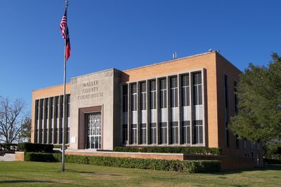
Waller County, County administrative division in Southeast Texas, US

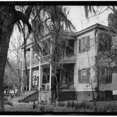
Waller County is an administrative district in Southeast Texas covering rural areas mixed with growing suburban development along Interstate 10. The county includes multiple towns such as Hempstead, Brookshire, Pattison, and Prairie View, each with their own character and services.

The county was established in 1873 and named after Edwin Waller, the first mayor of Austin and a signer of the Texas Declaration of Independence. Its creation reflected Texas's expanding settlement patterns during that era.

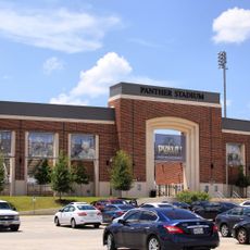
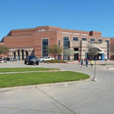
Prairie View A&M University shapes educational and community life throughout the county, serving as a gathering place for students and residents from surrounding areas. The institution influences local traditions and social connections across multiple generations.

The county sits along Interstate 10, making it easy to pass through or access different areas by car. Administrative services and facilities are distributed across the main towns for visitor convenience.

The county hosts headquarters for major companies including Igloo Products, Goya Foods, and the global base for Grundfos water pump technology. This industrial presence significantly shapes the local economy and employment landscape.

Location: Texas

Inception: 1873

Capital city: Hempstead

Shares border with: Montgomery County, Fort Bend County, Austin County, Harris County, Grimes County, Washington County

Website: http://co.waller.tx.us

GPS coordinates: 30.01000,-95.98000

Latest update: December 20, 2025 01:00

Photos
Around this place
Panther Stadium at Blackshear Field
United States of America

Panther Stadium at Blackshear Field

9.1 km
Typhoon Texas
United States of America

Typhoon Texas

30.8 km
United States of America

Stephen F. Austin State Park

24.9 km
Liendo Plantation
United States of America

Liendo Plantation

10.8 km
Leonard E. Merrell Center
United States of America

Leonard E. Merrell Center

29.3 km
San Felipe de Austin State Historic Site
United States of America

San Felipe de Austin State Historic Site

25.3 km
Dewberry Farm
United States of America

Dewberry Farm

13.9 km
United States of America

The John Fairey Garden

7.6 km
Dig World
United States of America

Dig World

30.5 km
B. Ray and Charlotte Woods House
United States of America

B. Ray and Charlotte Woods House

29.3 km
San Felipe de Austin State Historic Site
United States of America

San Felipe de Austin State Historic Site

25.4 km
Oil Ranch
United States of America

Oil Ranch

18.8 km
Katy Heritage Museum
United States of America

Katy Heritage Museum

28.5 km
United States of America

Prairie View A&M University, Annie Laurie Evans Hall

9.5 km
United States of America

Prairie View A&M University, W.R. Banks Library

9.3 km
United States of America

Prairie View A&M University, L.C. Anderson Hall

9.5 km
Prairie View A&M University, Veterinary Hospital
United States of America

Prairie View A&M University, Veterinary Hospital

9.3 km
United States of America

Frey-Benignus House

3.6 km
United States of America

Hill House

25.5 km
United States of America

Prairie View A&M University, Hilliard Hall

8.7 km
Ahrenbeck-Urban Home
United States of America

Ahrenbeck-Urban Home

13.6 km
United States of America

Stewart, Dr. James M. and Dove, House

28.9 km
United States of America

San Felipe United Methodist Church

25.6 km
United States of America

Pine Island Baptist Church

6.1 km
United States of America

San Felipe Town Hall

26 km
United States of America

Lambert House

25.7 km
United States of America

Paul and Mahala Hackbarth House

30.9 km
United States of America

Donigan House

25.1 km
Show the full map
Reviews

Visited this place? Tap the stars to rate it and share your experience / photos with the community! Try now! You can cancel it anytime.

Administrative divisions
« Waller County - County administrative division in Southeast Texas, US » is provided by Around Us (aroundus.com). Images and texts are derived from Wikimedia project under a Creative Commons license. You are allowed to copy, distribute, and modify copies of this page, under the conditions set by the license, as long as this note is clearly visible.

Discover hidden gems everywhere you go!

From secret cafés to breathtaking viewpoints, skip the crowded tourist spots and find places that match your style. Our app makes it easy with voice search, smart filtering, route optimization, and insider tips from travelers worldwide. Download now for the complete mobile experience.

Around Us App Screenshot

A unique approach to discovering new places

Le Figaro

All the places worth exploring

France Info

A tailor-made excursion in just a few clicks

20 Minutes