Chest opened
+${chestReward.xp} XP
Explorer
NOUVEAU ×${chestReward.collectible.quantity}
tapez pour fermer
Chest locked

Open chests in the app

Around Us is built for your phone — chests unlock when you walk, explore and capture nearby places.

Enable Location

We need your location to show you interesting places around you

Discover nearby places

Find interesting locations and hidden gems around you

Precise directions

Get accurate directions and distances to places

Your location is never shared with other users. It's only used when you tap the location button.

McGregor

Log in to your account

Start exploring — it's free

Trusted by 72,888 travelers worldwide

Continue with Google
Continue with Apple
or

We will send you a code to connect

By continuing, you accept our Terms and Conditions and our Privacy Policy

Check your inbox

We've sent a pincode in your inbox. Please enter the code below.

Discussion Reviews 1 Photos
33k Popularity

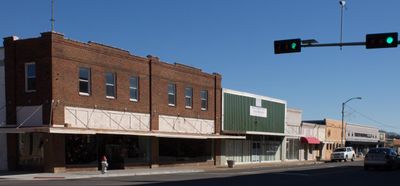
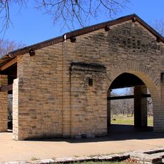
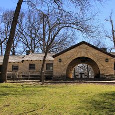
McGregor, Municipal center in McLennan County, Texas

McGregor is a city in central Texas that spans two counties with residential neighborhoods, business districts, and industrial areas working together. The place functions as a regional hub where everyday residential life and economic activity coexist within a compact framework.

The city grew around the Bluebonnet Ordnance Plant, a World War II military manufacturing facility that produced military equipment. After the war, industries shifted and adapted, creating new economic foundations that shaped the community's development.

The Founders Day celebration takes place every third Saturday in September, bringing together local residents for community activities, food, and entertainment.

U.S. Route 84 and Texas State Highway 317 cross through the city, connecting it directly to Waco, Gatesville, and nearby towns. Travelers can use these main roads to enter and explore, or to reach other areas in the region.

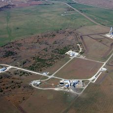
SpaceX operates a major rocket engine development and testing facility here, where regular experimental test fires take place. This makes the city an overlooked hub of aerospace technology in the American South.

The community of curious travelers

AroundUs brings together thousands of curated places, local tips, and hidden gems, enriched daily by 60,000 contributors worldwide.

Start exploring
Location
Location
Elevation above the sea
211 m
GPS coordinates
31.44406,-97.40918
Latest update
December 19, 2025 23:59
Around this place
Mother Neff State Park
United States of America

Mother Neff State Park

15.5 km
SpaceX Rocket Development and Test Facility
United States of America

SpaceX Rocket Development and Test Facility

7.3 km
Mother Neff State Park Recreational Pavilion
United States of America

Mother Neff State Park Recreational Pavilion

15.5 km
Water Tower
United States of America

Water Tower

14.8 km
United States of America

Mother Neff State Park and F. A. S. 21-B(1) Historic District

14.8 km
Clubhouse
United States of America

Clubhouse

15.5 km
United States of America

First Methodist Church of Oglesby

10.1 km
Caretaker's House
United States of America

Caretaker's House

14.8 km
United States of America

Soil Conservation Service Site 4 Reservoir

18.3 km
United States of America

Kuykendall House

15.8 km
United States of America

Soil Conservation Service Site 23 Reservoir

15.2 km
United States of America

Soil Conservation Service Site 21 Reservoir

13 km
United States of America

H. J. and Cora Hudson House

19.6 km
United States of America

Eddy Methodist Church

21.9 km
United States of America

Mother Neff State Park Headquarters and Visitor Center

15.4 km
United States of America

The Isaac Jackson Teague Property

10.3 km
United States of America

The Howard House

15.9 km
United States of America

Lorena United Methodist Church

19.6 km
United States of America

Deyerle-Fall House

3 km
United States of America

Flowers House

21.8 km
United States of America

Glenn and Mary Gulledge Crain House

1.1 km
United States of America

Coryell Baptist Church

13.8 km
United States of America

Hill House

16 km
United States of America

Bear Ridge Golf Course

13.3 km
United States of America

Historic Bell

14.1 km
United States of America

CCC Rock Tower

14.8 km
United States of America

Creekside Amphitheater

21 km
United States of America

Waterfall

10.6 km
Show the full map
Reviews
Share your experience

No review yet

Discussions
Start a discussion...

No discussion yet

« McGregor - Municipal center in McLennan County, Texas » is provided by Around Us (aroundus.com). Images and texts are derived from Wikimedia project under a Creative Commons license. You are allowed to copy, distribute, and modify copies of this page, under the conditions set by the license, as long as this note is clearly visible.

Discover hidden gems everywhere you go!

From secret cafés to breathtaking viewpoints, skip the crowded tourist spots and find places that match your style. Our app makes it easy with voice search, smart filtering, route optimization, and insider tips from travelers worldwide. Download now for the complete mobile experience.

Around Us App Screenshot

A unique approach to discovering new places

Le Figaro

All the places worth exploring

France Info

A tailor-made excursion in just a few clicks

20 Minutes

Around Us
Travel Guide & Maps
Download

Send to your phone

QR Code
1

Open the camera app on your mobile.

2

Point at the QR code with your camera. A notification will appear.

3

Tap the notification to open the link.