Chest opened
+${chestReward.xp} XP
Explorer
NOUVEAU ×${chestReward.collectible.quantity}
tapez pour fermer
Chest locked

Open chests in the app

Around Us is built for your phone — chests unlock when you walk, explore and capture nearby places.

Enable Location

We need your location to show you interesting places around you

Discover nearby places

Find interesting locations and hidden gems around you

Precise directions

Get accurate directions and distances to places

Your location is never shared with other users. It's only used when you tap the location button.

Mexia

Log in to your account

Start exploring — it's free

Trusted by 72,888 travelers worldwide

Continue with Google
Continue with Apple
or

We will send you a code to connect

By continuing, you accept our Terms and Conditions and our Privacy Policy

Check your inbox

We've sent a pincode in your inbox. Please enter the code below.

Discussion Reviews 1 Photos
49.4k Popularity

Mexia, Railroad city in Limestone County, Texas.

Mexia is a city in Limestone County, Texas, located at the intersection of U.S. Highway 84 and State Highways 14 and 171, approximately 40 miles east of Waco. The downtown area has a traditional layout with commercial buildings, a municipal center, and residential neighborhoods spreading outward.

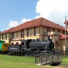
The Houston and Texas Central Townsite Company founded the city in 1870, and it was incorporated in 1873 as rail connections expanded rapidly. The railroad presence transformed it into a key regional junction for moving goods and passengers.

The Mexia Public Schools Museum displays the evolution of Texas education through a collection of teaching materials and historical objects. Visitors can see how school practices and resources changed over time.

The downtown core is easy to navigate with a compact layout and parking available near the main streets. The city has basic amenities including restaurants, shops, and public services within walking distance of the center.

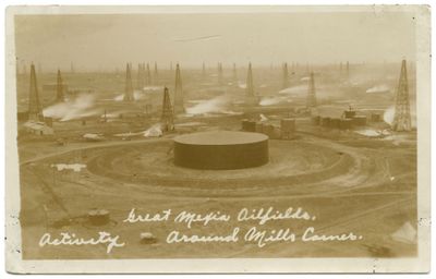
Natural gas was discovered beneath the land in 1912, followed by oil deposits in 1920, completely shifting the local economy. These energy finds brought workers and investment, turning the region into a major production hub.

The community of curious travelers

AroundUs brings together thousands of curated places, local tips, and hidden gems, enriched daily by 60,000 contributors worldwide.

Start exploring
Location
Elevation above the sea
159 m
GPS coordinates
31.68167,-96.48111
Latest update
December 14, 2025 18:55
Around this place
Fort Parker State Park
United States of America

Fort Parker State Park

10.9 km
Confederate Reunion Grounds State Historic Site
United States of America

Confederate Reunion Grounds State Historic Site

9.2 km
Texas Hall
United States of America

Texas Hall

9.2 km
Trinity and Brazos Valley Railroad Depot and Office Building
United States of America

Trinity and Brazos Valley Railroad Depot and Office Building

19.6 km
Confederate Reunion Grounds State Historic Site
United States of America

Confederate Reunion Grounds State Historic Site

9.3 km
United States of America

Browns Lake

19.4 km
United States of America

Soil Conservation Service Site 24 Reservoir

12.3 km
United States of America

Wortham Lake Number 1

13.5 km
Freestone County Courthouse
United States of America

Freestone County Courthouse

30.8 km
United States of America

Soil Conservation Service Site 6 Reservoir

29.1 km
United States of America

Teague City Lake

15.1 km
United States of America

Mexia Theater

350 m
United States of America

L. P. Smith House

183 m
United States of America

Lake Mexia

11.5 km
United States of America

Soil Conservation Service Site 4 Reservoir

28.6 km
United States of America

Loper Lake

19.8 km
United States of America

Duke Lake

18.5 km
United States of America

Soil Conservation Service Site 30 Reservoir

20 km
United States of America

Soil Conservation Service Site 23 Reservoir

12.6 km
United States of America

Soil Conservation Service Site 15 Reservoir

20.3 km
United States of America

Booker T Washington Emancipation Proclamation Park

11.3 km
United States of America

Bradley House

30.6 km
United States of America

Manahan House

30.8 km
United States of America

Old Fort Parker

12.6 km
United States of America

Early Mexia Home

993 m
United States of America

The Dr. Emmet Headlee House

20.3 km
United States of America

Miss Rogers' Music Room

1.3 km
United States of America

Stewards Mill Store, 1869

30.4 km
Show the full map
Reviews
Share your experience

No review yet

Discussions
Start a discussion...

No discussion yet

« Mexia - Railroad city in Limestone County, Texas » is provided by Around Us (aroundus.com). Images and texts are derived from Wikimedia project under a Creative Commons license. You are allowed to copy, distribute, and modify copies of this page, under the conditions set by the license, as long as this note is clearly visible.

Discover hidden gems everywhere you go!

From secret cafés to breathtaking viewpoints, skip the crowded tourist spots and find places that match your style. Our app makes it easy with voice search, smart filtering, route optimization, and insider tips from travelers worldwide. Download now for the complete mobile experience.

Around Us App Screenshot

A unique approach to discovering new places

Le Figaro

All the places worth exploring

France Info

A tailor-made excursion in just a few clicks

20 Minutes

Around Us
Travel Guide & Maps
Download

Send to your phone

QR Code
1

Open the camera app on your mobile.

2

Point at the QR code with your camera. A notification will appear.

3

Tap the notification to open the link.