Enable Location

We need your location to show you interesting places around you

Discover nearby places

Find interesting locations and hidden gems around you

Precise directions

Get accurate directions and distances to places

Your location is never shared with other users. It's only used when you tap the location button.

Bottle Creek Indian Mounds

Log in to your account

Start exploring — it's free

Trusted by 61,368 travelers worldwide

Continue with Google
Continue with Apple
or

We will send you a code to connect

By continuing, you accept our Terms and Conditions and our Privacy Policy

Check your inbox

We've sent a pincode in your inbox. Please enter the code below.

Bottle Creek Indian Mounds, Archaeological site in Mobile-Tensaw Delta, Alabama.

Description

Bottle Creek Indian Mounds is an archaeological site in the Mobile-Tensaw Delta swamp featuring eighteen earth mounds arranged around a central plaza. The tallest of these structures rises approximately 52 feet (16 m) above the surrounding wetland.

History

This location served as the major center of the Pensacola culture from 1250 to 1550, a period when it functioned as a key political and economic hub. Early French explorers documented the site in the early 1700s, creating some of the first written records about the place.

Culture

The residents of this location were part of extensive trade networks that connected coastal and inland communities across the region. Objects found here show trade relationships that spanned hundreds of kilometers and included goods from the Gulf coast and distant northern areas.

Practical

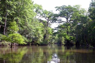
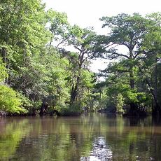
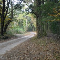
Access to this site requires a guided boat tour departing from Stockton, Alabama, with trips typically lasting between four to eight hours depending on water levels and conditions. Visitors should prepare for navigation through dense cypress stands and bring appropriate clothing for a journey in a swampy environment.

Did you know?

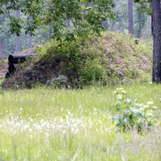
The site's location surrounded by dense cypress forest has kept the mounds remarkably well preserved, making it the most intact archaeological complex of its kind on the northern Gulf coastal plain. This natural protection from the swampland allowed structures and artifacts to survive largely undisturbed for over a thousand years.

Location
GPS coordinates
31.00880,-87.94060
Latest update
December 9, 2025 18:43

AroundUs brings together thousands of curated places, local tips, and hidden gems, enriched daily by 60,000 contributors worldwide. Discover all places nearby (Alabama).

Around this place
Africatown
United States of America

Africatown

32.5 km
General W.K. Wilson Jr. Bridge
United States of America

General W.K. Wilson Jr. Bridge

10.8 km
LeFlore Magnet High School
United States of America

LeFlore Magnet High School

35.6 km
Mobile-Tensaw River Delta
United States of America

Mobile-Tensaw River Delta

28.3 km
Cochrane–Africatown USA Bridge
United States of America

Cochrane–Africatown USA Bridge

32.2 km
Blakeley
United States of America

Blakeley

29.7 km
Historic Blakeley State Park
United States of America

Historic Blakeley State Park

29.7 km
Mount Vernon Arsenal
United States of America

Mount Vernon Arsenal

12.2 km
Ellicott's Stone
United States of America

Ellicott's Stone

7.9 km
The Catholic Cemetery of Mobile
United States of America

The Catholic Cemetery of Mobile

35.6 km
Richards DAR House
United States of America

Richards DAR House

36.3 km
Saint Francis Xavier Roman Catholic Church
United States of America

Saint Francis Xavier Roman Catholic Church

35.9 km
Magee Farm
United States of America

Magee Farm

29.8 km
Aimwell Baptist Church
United States of America

Aimwell Baptist Church

36.1 km
Chickasaw Shipyard Village Historic District
United States of America

Chickasaw Shipyard Village Historic District

30.5 km
Andrews Chapel
United States of America

Andrews Chapel

29.7 km
N.Q. and Virginia M. Thompson House
United States of America

N.Q. and Virginia M. Thompson House

29.1 km
Latham United Methodist Church
United States of America

Latham United Methodist Church

14.5 km
First Baptist Church
United States of America

First Baptist Church

20.9 km
Emanuel Building
United States of America

Emanuel Building

36.3 km
Montgomery Hill Baptist Church
United States of America

Montgomery Hill Baptist Church

22.6 km
Citronelle Railroad Historic District
United States of America

Citronelle Railroad Historic District

28.8 km
Nelson House
United States of America

Nelson House

13.5 km
Willis G. Clark House
United States of America

Willis G. Clark House

25.7 km
Davis-Oak Grove District
United States of America

Davis-Oak Grove District

28.7 km
Central Core Historic District
United States of America

Central Core Historic District

28.4 km
Stockton Methodist Church
United States of America

Stockton Methodist Church

8.4 km
Barr's Subdivision Historic District
United States of America

Barr's Subdivision Historic District

29.9 km
Show the full map
« Bottle Creek Indian Mounds - Archaeological site in Mobile-Tensaw Delta, Alabama » is provided by Around Us (aroundus.com). Images and texts are derived from Wikimedia project under a Creative Commons license. You are allowed to copy, distribute, and modify copies of this page, under the conditions set by the license, as long as this note is clearly visible.

Discover hidden gems everywhere you go!

From secret cafés to breathtaking viewpoints, skip the crowded tourist spots and find places that match your style. Our app makes it easy with voice search, smart filtering, route optimization, and insider tips from travelers worldwide. Download now for the complete mobile experience.

Around Us App Screenshot

A unique approach to discovering new places

Le Figaro

All the places worth exploring

France Info

A tailor-made excursion in just a few clicks

20 Minutes

Around Us
Travel Guide & Maps
Download

Send to your phone

QR Code
1

Open the camera app on your mobile.

2

Point at the QR code with your camera. A notification will appear.

3

Tap the notification to open the link.