Enable Location

We need your location to show you interesting places around you

Discover nearby places

Find interesting locations and hidden gems around you

Precise directions

Get accurate directions and distances to places

Your location is never shared with other users. It's only used when you tap the location button.

Tennessee-Tombigbee Waterway

Log in to your account

Start exploring — it's free

Trusted by 62,454 travelers worldwide

Continue with Google
Continue with Apple
or

We will send you a code to connect

By continuing, you accept our Terms and Conditions and our Privacy Policy

Check your inbox

We've sent a pincode in your inbox. Please enter the code below.

Tennessee-Tombigbee Waterway

Tennessee-Tombigbee Waterway, Artificial waterway between Tennessee and Tombigbee Rivers in Alabama and Mississippi, United States.

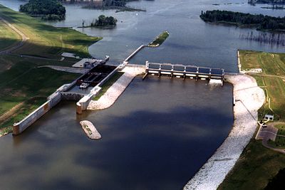
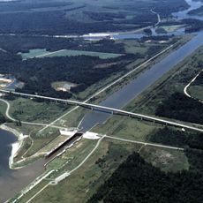
The Tennessee-Tombigbee Waterway is an artificial connection between two rivers in Alabama and Mississippi, stretching across multiple sections. Ten locks and dams regulate water flow to enable navigation throughout the region.

The project began in 1972 and was completed in 1984 as one of the largest infrastructure investments of its era. The artificial connection changed transportation patterns and economic development in the region.

The waterway links communities along its route and has created new gathering spots for commerce and leisure. Today, people use it for fishing, boating, and experiencing the surrounding natural areas.

Along the route, visitors find various boat ramps, campgrounds, and recreational areas to explore. The best time to visit is spring through fall, when water conditions and accessibility are at their peak.

Construction required excavation of a 175-foot (53 m) deep cut between two watersheds. This was one of the largest earth-moving projects in United States history.

The community of curious travelers

AroundUs brings together thousands of curated places, local tips, and hidden gems, enriched daily by 60,000 contributors worldwide.

Start exploring
Inception
1984
Elevation above the sea
33 m
GPS coordinates
32.83902,-88.16669
Latest update
December 19, 2025 22:33
Around this place
Fort Tombecbe
United States of America

Fort Tombecbe

16.3 km
Aduston Hall
United States of America

Aduston Hall

3 km
Kirkwood
United States of America

Kirkwood

25.3 km
Everhope Plantation
United States of America

Everhope Plantation

19.7 km
Boligee Hill
United States of America

Boligee Hill

18.8 km
First Presbyterian Church
United States of America

First Presbyterian Church

25.8 km
Howell Heflin Lock and Dam
United States of America

Howell Heflin Lock and Dam

2.9 km
Edwin Reese House
United States of America

Edwin Reese House

25.9 km
Catlin Wilson House
United States of America

Catlin Wilson House

26.1 km
Oakhurst
United States of America

Oakhurst

11.5 km
Antebellum Homes in Eutaw TR
United States of America

Antebellum Homes in Eutaw TR

26.1 km
Dr. Willis Meriwether House
United States of America

Dr. Willis Meriwether House

26.1 km
Old Greene County Courthouse
United States of America

Old Greene County Courthouse

26.2 km
David Rinehart Anthony House
United States of America

David Rinehart Anthony House

26.1 km
Attoway R. Davis Home
United States of America

Attoway R. Davis Home

26 km
Gainesville Historic District
United States of America

Gainesville Historic District

2.8 km
Coleman-Banks House
United States of America

Coleman-Banks House

26.1 km
Main–Yankee Street Historic District
United States of America

Main–Yankee Street Historic District

2.3 km
Rev. John H. Gray House
United States of America

Rev. John H. Gray House

25 km
Colonel Green G. Mobley House
United States of America

Colonel Green G. Mobley House

2.4 km
Stephen Fowler Hale House
United States of America

Stephen Fowler Hale House

26 km
Greene County Courthouse Square District
United States of America

Greene County Courthouse Square District

26.1 km
Samuel W. Cockrell House
United States of America

Samuel W. Cockrell House

26.1 km
Gibbs House
United States of America

Gibbs House

2.9 km
William Peter Webb House
United States of America

William Peter Webb House

25.8 km
William A. Rogers House
United States of America

William A. Rogers House

24.3 km
William C. Jones House
United States of America

William C. Jones House

25.5 km
William F. Pierce House
United States of America

William F. Pierce House

25.3 km
Show the full map
« Tennessee-Tombigbee Waterway - Artificial waterway between Tennessee and Tombigbee Rivers in Alabama and Mississippi, United States » is provided by Around Us (aroundus.com). Images and texts are derived from Wikimedia project under a Creative Commons license. You are allowed to copy, distribute, and modify copies of this page, under the conditions set by the license, as long as this note is clearly visible.

Discover hidden gems everywhere you go!

From secret cafés to breathtaking viewpoints, skip the crowded tourist spots and find places that match your style. Our app makes it easy with voice search, smart filtering, route optimization, and insider tips from travelers worldwide. Download now for the complete mobile experience.

Around Us App Screenshot

A unique approach to discovering new places

Le Figaro

All the places worth exploring

France Info

A tailor-made excursion in just a few clicks

20 Minutes

Around Us
Travel Guide & Maps
Download

Send to your phone

QR Code
1

Open the camera app on your mobile.

2

Point at the QR code with your camera. A notification will appear.

3

Tap the notification to open the link.