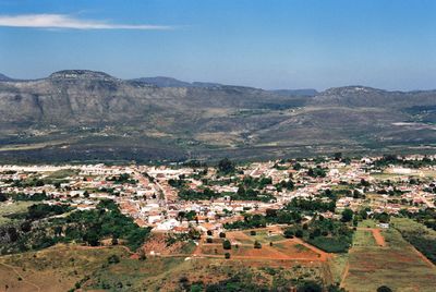
Piatã, Mountain municipality in Bahia, Brazil.
Piatã is a municipality set on elevated terrain in Bahia, located around 1,268 meters above sea level in the eastern part of the state. The landscape is hilly and shapes how communities are arranged across the region.
The municipality became officially established in 1962, marking an important shift in Bahia's administrative structure. This change allowed the area to govern itself separately and make its own decisions.
The town holds celebrations that blend Indigenous, African, and European traditions, reflecting the diverse communities that have shaped life here. These festivities are woven into the rhythm of daily life and show how different cultures coexist in this place.
Travelers can reach the municipality by paved roads connecting to larger cities in Bahia, with regular bus services from the state capital Salvador. The terrain is hilly, so plan journeys with adequate time and choose dry seasons for easier travel.
The municipality experiences some of the coolest temperatures in Bahia because of its high elevation, creating a different climate than surrounding areas. This fresher weather stands out noticeably compared to the hotter, more humid regions nearby.
The community of curious travelers
AroundUs brings together thousands of curated places, local tips, and hidden gems, enriched daily by 60,000 contributors worldwide.