Enable Location

We need your location to show you interesting places around you

Discover nearby places

Find interesting locations and hidden gems around you

Precise directions

Get accurate directions and distances to places

Your location is never shared with other users. It's only used when you tap the location button.

Rio Grande City

Log in to your account

Start exploring — it's free

Trusted by 62,492 travelers worldwide

Continue with Google
Continue with Apple
or

We will send you a code to connect

By continuing, you accept our Terms and Conditions and our Privacy Policy

Check your inbox

We've sent a pincode in your inbox. Please enter the code below.

Rio Grande City, County seat in Starr County, Texas, United States

Rio Grande City is the county seat of Starr County, situated on the northern bank of the Rio Grande along the Texas-Mexico border. The town spreads along the river at an elevation of around 53 feet (16 meters) and functions as a key crossing point between the two nations.

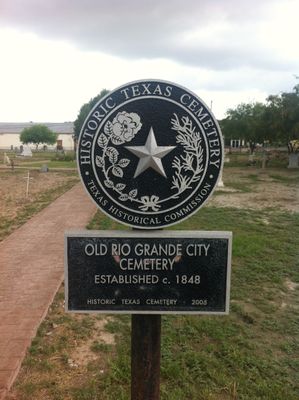
The settlement began as a United States Army supply post during the Mexican-American War and was officially established in 1848. Fort Ringgold, built that same year, remained active as a military base until 1944, when it transferred to the local school district.

The International Bridge links the town to Camargo across the river, creating daily contact between residents from both sides of the border. This connection shapes local traditions and how people experience life in the community.

The town has multiple schools managed by the Rio Grande City Grulla Independent School District, ranging from elementary to high school levels. As a border town, the proximity to Mexico shapes daily routines and visitor experiences in the area.

The town originated as a military supply point during wartime between two nations before becoming a civilian settlement. This unusual foundation shaped how the place developed compared to many other border communities.

The community of curious travelers

AroundUs brings together thousands of curated places, local tips, and hidden gems, enriched daily by 60,000 contributors worldwide.

Start exploring
Location
Inception
1848
Elevation above the sea
53 m
GPS coordinates
26.38060,-98.81830
Latest update
December 20, 2025 01:28
Around this place
Roma Historic District
United States of America

Roma Historic District

20.1 km
Mexico

Roma – Ciudad Miguel Alemán International Bridge

20.2 km
Mexico

Rio Grande City – Camargo International Bridge

2.3 km
United States of America

Soil Conservation Service Site 7 Reservoir

7.7 km
United States of America

Miguel Aleman International Suspension Bridge

20.1 km
United States of America

Roma-San Pedro International Bridge

20.1 km
United States of America

LaBorde House, Store and Hotel

432 m
United States of America

First Chapel in Roma

20.1 km
United States of America

Soil Conservation Service Site 1 Reservoir

27.9 km
United States of America

Knights of Columbus Hall

20.2 km
United States of America

Early Commercial Center

20.2 km
United States of America

Fort Ringgold Historic District

1.2 km
United States of America

Rio Grande City Downtown Historic District

334 m
United States of America

Vale-Cox House

19.5 km
United States of America

Old Ringgold Barracks Hospital

1 km
United States of America

Roma City Hall

20.3 km
United States of America

Old Roma Convent Building

20.2 km
United States of America

Old Garcia Home

20.2 km
United States of America

Manuel Guerra Home and Store

20.2 km
United States of America

Memorial Hospital

20.2 km
United States of America

Mifflin Kenedy Warehouse & Old Starr County Courthouse

449 m
United States of America

Fred & Nell Kain Guerra House

994 m
United States of America

Yzaguirre-Longoria House

414 m
United States of America

Howard L. Bass Home

84 m
United States of America

John Peter Kelsey Home

142 m
United States of America

Ramirez Hall

20.2 km
United States of America

Robert E. Lee House

1.2 km
Mexico

Casa de Cultura

7.3 km
Show the full map
« Rio Grande City - County seat in Starr County, Texas, United States » is provided by Around Us (aroundus.com). Images and texts are derived from Wikimedia project under a Creative Commons license. You are allowed to copy, distribute, and modify copies of this page, under the conditions set by the license, as long as this note is clearly visible.

Discover hidden gems everywhere you go!

From secret cafés to breathtaking viewpoints, skip the crowded tourist spots and find places that match your style. Our app makes it easy with voice search, smart filtering, route optimization, and insider tips from travelers worldwide. Download now for the complete mobile experience.

Around Us App Screenshot

A unique approach to discovering new places

Le Figaro

All the places worth exploring

France Info

A tailor-made excursion in just a few clicks

20 Minutes

Around Us
Travel Guide & Maps
Download

Send to your phone

QR Code
1

Open the camera app on your mobile.

2

Point at the QR code with your camera. A notification will appear.

3

Tap the notification to open the link.