Enable Location

We need your location to show you interesting places around you

Discover nearby places

Find interesting locations and hidden gems around you

Precise directions

Get accurate directions and distances to places

Your location is never shared with other users. It's only used when you tap the location button.

Log in to your account

Start exploring — it's free

Trusted by 62,493 travelers worldwide

Continue with Google
Continue with Apple
or

We will send you a code to connect

By continuing, you accept our Terms and Conditions and our Privacy Policy

Check your inbox

We've sent a pincode in your inbox. Please enter the code below.

Rio Grande City – Camargo International Bridge

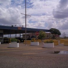
Rio Grande City – Camargo International Bridge, International toll bridge in Rio Grande City, United States.

The Rio Grande City-Camargo Bridge is a toll road bridge that crosses the Rio Grande River and links Texas directly with Mexico. The structure allows vehicles to move across the border in both directions after passing through customs stations at each end.

The bridge opened in 1966 and created a permanent connection between Rio Grande City and Camargo. Its completion strengthened economic ties between the two countries and simplified trade and personal travel across what had been a more difficult border to cross.

The crossing is a space where people from Texas and Tamaulipas see each other regularly, with families, workers, and traders moving back and forth daily. This constant flow shapes the character of both sides and makes the bridge a lived example of cross-border community.

Vehicles can use the bridge in both directions during operating hours, but must pay tolls and present documents at checkpoints on each side. It is wise to check opening times in advance and expect longer wait times during busy periods.

Hundreds of trucks cross daily alongside regular cars, making this one of the major trade corridors between North and South America. This intense commercial activity is visible to any visitor and shows how critical this border crossing is for both regions.

The community of curious travelers

AroundUs brings together thousands of curated places, local tips, and hidden gems, enriched daily by 60,000 contributors worldwide.

Start exploring
Part of
Mexico–United States border
GPS coordinates
26.36571,-98.80252
Latest update
December 14, 2025 14:22
Around this place
Falcon International Reservoir
Mexico

Falcon International Reservoir

42 km
Basilica of the National Shrine of Our Lady of San Juan del Valle
United States of America

Basilica of the National Shrine of Our Lady of San Juan del Valle

67 km
Santa Ana National Wildlife Refuge
United States of America

Santa Ana National Wildlife Refuge

73.7 km
National Butterfly Center
United States of America

National Butterfly Center

48.3 km
La Lomita Chapel
United States of America

La Lomita Chapel

52.5 km
Lower Rio Grande Valley National Wildlife Refuge
United States of America

Lower Rio Grande Valley National Wildlife Refuge

97 km
Bentsen-Rio Grande Valley State Park
United States of America

Bentsen-Rio Grande Valley State Park

47.1 km
McAllen–Hidalgo–Reynosa International Bridge
Mexico

McAllen–Hidalgo–Reynosa International Bridge

61 km
El Sabinal National Park
Mexico

El Sabinal National Park

87.7 km
McAllen Convention Center
United States of America

McAllen Convention Center

57.2 km
McAllen Public Library
United States of America

McAllen Public Library

57.6 km
McAllen Botanical Gardens
United States of America

McAllen Botanical Gardens

58.9 km
Estero Llano Grande State Park
United States of America

Estero Llano Grande State Park

88.5 km
First Lift Station
United States of America

First Lift Station

50.1 km
Roma Historic District
United States of America

Roma Historic District

22 km
Falcon Dam Port of Entry
United States of America

Falcon Dam Port of Entry

40 km
Topgolf
United States of America

Topgolf

62.9 km
Veterans War Memorial of Texas
United States of America

Veterans War Memorial of Texas

57.6 km
Trevino-Uribe Rancho
United States of America

Trevino-Uribe Rancho

98.9 km
Border Theater
United States of America

Border Theater

50.4 km
Pharr Aquatic Center
United States of America

Pharr Aquatic Center

65.5 km
M and J Nelson Building
United States of America

M and J Nelson Building

59.5 km
Reynosakatedralen
Mexico

Reynosakatedralen

60.6 km
Mcallen public pool
United States of America

Mcallen public pool

58.6 km
McAllen Heritage Center
United States of America

McAllen Heritage Center

59.6 km
Rio Theater
United States of America

Rio Theater

50.5 km
Garmon Theater
United States of America

Garmon Theater

2.1 km
Capilla de San Juan Bautista
Mexico

Capilla de San Juan Bautista

35.2 km
Show the full map
« Rio Grande City – Camargo International Bridge - International toll bridge in Rio Grande City, United States » is provided by Around Us (aroundus.com). Images and texts are derived from Wikimedia project under a Creative Commons license. You are allowed to copy, distribute, and modify copies of this page, under the conditions set by the license, as long as this note is clearly visible.

Discover hidden gems everywhere you go!

From secret cafés to breathtaking viewpoints, skip the crowded tourist spots and find places that match your style. Our app makes it easy with voice search, smart filtering, route optimization, and insider tips from travelers worldwide. Download now for the complete mobile experience.

Around Us App Screenshot

A unique approach to discovering new places

Le Figaro

All the places worth exploring

France Info

A tailor-made excursion in just a few clicks

20 Minutes

Around Us
Travel Guide & Maps
Download

Send to your phone

QR Code
1

Open the camera app on your mobile.

2

Point at the QR code with your camera. A notification will appear.

3

Tap the notification to open the link.