Chest opened
+${chestReward.xp} XP
Explorer
NOUVEAU ×${chestReward.collectible.quantity}
tapez pour fermer
Chest locked

Open chests in the app

Around Us is built for your phone — chests unlock when you walk, explore and capture nearby places.

Enable Location

We need your location to show you interesting places around you

Discover nearby places

Find interesting locations and hidden gems around you

Precise directions

Get accurate directions and distances to places

Your location is never shared with other users. It's only used when you tap the location button.

Choctawhatchee River

Log in to your account

Start exploring — it's free

Trusted by 72,877 travelers worldwide

Continue with Google
Continue with Apple
or

We will send you a code to connect

By continuing, you accept our Terms and Conditions and our Privacy Policy

Check your inbox

We've sent a pincode in your inbox. Please enter the code below.

Choctawhatchee River
Discussion Reviews 1 Photos
10.4k Popularity

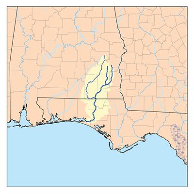
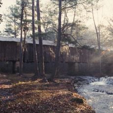
Choctawhatchee River, River system from Alabama to Florida, United States.

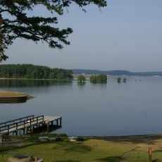
The Choctawhatchee River is a river system flowing roughly 141 miles across southeast Alabama and Florida's Panhandle. It ends where it meets Choctawhatchee Bay, which opens to the Gulf of Mexico.

The waterway has long served as a transportation route dating back to early settlement times. In 1814, General Andrew Jackson built a military stockade called the Block House at the junction of the river's eastern and western branches.

Indigenous peoples like the Euchee used this waterway as a vital trade route and traveled the same waters for generations. Local communities today still value the river as a connection to their land and natural heritage.

The river provides multiple access points where anglers can reach the water to fish for various species. Visitors should check with local fishing guides or outfitters to learn about the best locations for different seasons.

The river maintains about 21 freshwater mussel species, including seven types found nowhere else in the world. These specialized creatures depend on the specific conditions this waterway provides.

The community of curious travelers

AroundUs brings together thousands of curated places, local tips, and hidden gems, enriched daily by 60,000 contributors worldwide.

Start exploring
Location
Location
GPS coordinates
31.36120,-85.55270
Latest update
December 10, 2025 15:54
Around this place
Boll Weevil Monument
United States of America

Boll Weevil Monument

29.1 km
Kolomoki Mounds State Park
United States of America

Kolomoki Mounds State Park

60.8 km
United States Army Aviation Museum
United States of America

United States Army Aviation Museum

15.8 km
George T. Bagby State Park
United States of America

George T. Bagby State Park

57.9 km
Fendall Hall
United States of America

Fendall Hall

60.3 km
Henry D. Clayton House
United States of America

Henry D. Clayton House

57 km
Wiregrass Museum of Art
United States of America

Wiregrass Museum of Art

21.8 km
Army Aviation Museum Foundation
United States of America

Army Aviation Museum Foundation

15.7 km
Dothan Opera House
United States of America

Dothan Opera House

21.7 km
Coffee County Courthouse
United States of America

Coffee County Courthouse

48.8 km
Early County Courthouse
United States of America

Early County Courthouse

58.8 km
Claybank Log Church
United States of America

Claybank Log Church

14 km
Water World
United States of America

Water World

17.4 km
Coheelee Creek Covered Bridge
United States of America

Coheelee Creek Covered Bridge

45.5 km
Grace Episcopal Church
United States of America

Grace Episcopal Church

58.3 km
Petty-Roberts-Beatty House
United States of America

Petty-Roberts-Beatty House

58.4 km
Keith Cabin
United States of America

Keith Cabin

53.8 km
Kennedy House
United States of America

Kennedy House

36.7 km
Federal Building and United States Courthouse
United States of America

Federal Building and United States Courthouse

21.5 km
Purcell-Killingsworth House
United States of America

Purcell-Killingsworth House

42.6 km
Adventure Land Theme Park
United States of America

Adventure Land Theme Park

17.3 km
Dill House
United States of America

Dill House

55.1 km
Blakely Court Square Historic District
United States of America

Blakely Court Square Historic District

58.8 km
Miller-Martin Town House
United States of America

Miller-Martin Town House

58 km
Clay County Courthouse
United States of America

Clay County Courthouse

55 km
Jane Donalson Harrell House
United States of America

Jane Donalson Harrell House

61.3 km
Confederate Flagpole at Blakley
United States of America

Confederate Flagpole at Blakley

58.8 km
Splash Pad
United States of America

Splash Pad

23.7 km
Show the full map
Reviews
Share your experience

No review yet

Discussions
Start a discussion...

No discussion yet

« Choctawhatchee River - River system from Alabama to Florida, United States » is provided by Around Us (aroundus.com). Images and texts are derived from Wikimedia project under a Creative Commons license. You are allowed to copy, distribute, and modify copies of this page, under the conditions set by the license, as long as this note is clearly visible.

Discover hidden gems everywhere you go!

From secret cafés to breathtaking viewpoints, skip the crowded tourist spots and find places that match your style. Our app makes it easy with voice search, smart filtering, route optimization, and insider tips from travelers worldwide. Download now for the complete mobile experience.

Around Us App Screenshot

A unique approach to discovering new places

Le Figaro

All the places worth exploring

France Info

A tailor-made excursion in just a few clicks

20 Minutes

Around Us
Travel Guide & Maps
Download

Send to your phone

QR Code
1

Open the camera app on your mobile.

2

Point at the QR code with your camera. A notification will appear.

3

Tap the notification to open the link.