Chest opened
+${chestReward.xp} XP
Explorer
NOUVEAU ×${chestReward.collectible.quantity}
tapez pour fermer
Chest locked

Open chests in the app

Around Us is built for your phone — chests unlock when you walk, explore and capture nearby places.

Enable Location

We need your location to show you interesting places around you

Discover nearby places

Find interesting locations and hidden gems around you

Precise directions

Get accurate directions and distances to places

Your location is never shared with other users. It's only used when you tap the location button.

Log in to your account

Start exploring — it's free

Trusted by 72,939 travelers worldwide

Continue with Google
Continue with Apple
or

We will send you a code to connect

By continuing, you accept our Terms and Conditions and our Privacy Policy

Check your inbox

We've sent a pincode in your inbox. Please enter the code below.

LORAN-C transmitter Malone
Discussion Reviews Photo
1.3k Popularity

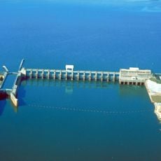
LORAN-C transmitter Malone, Military radio navigation transmitter in Malone, Florida, United States.

The LORAN-C transmitter in Malone was a radio navigation facility with a 213-meter tall antenna mast that operated at 800 kilowatts of transmission power. The station was designed to serve as the master transmitter for the Southeast U.S. LORAN-C Chain.

The station opened in July 1978 and provided navigation signals to the Southeast U.S. for 30 years. By February 2010, the facility was shut down and all structures were removed from the site.

The transmitter was part of a radio navigation system that guided ships and aircraft before GPS technology became widespread. This type of facility shaped how people navigated the seas for decades.

The site is not accessible to visitors today since all buildings and equipment have been removed. No physical remains of the original facility are visible at the location.

The facility maintained a remarkable record of 235 consecutive days without any signal failures. This level of reliability was vital for the safety of maritime and air traffic in the region.

The community of curious travelers

AroundUs brings together thousands of curated places, local tips, and hidden gems, enriched daily by 60,000 contributors worldwide.

Start exploring
Location
GPS coordinates
30.99420,-85.16920
Latest update
December 14, 2025 18:07
Around this place
Lake Seminole
United States of America

Lake Seminole

41.8 km
Florida Caverns State Park
United States of America

Florida Caverns State Park

21 km
Falling Waters State Park
United States of America

Falling Waters State Park

45.4 km
Jim Woodruff Dam
United States of America

Jim Woodruff Dam

43.2 km
Wiregrass Museum of Art
United States of America

Wiregrass Museum of Art

33 km
Dothan Opera House
United States of America

Dothan Opera House

33.2 km
Joseph W. Russ Jr. House
United States of America

Joseph W. Russ Jr. House

25 km
Great Oaks
United States of America

Great Oaks

13.8 km
Marianna Historic District
United States of America

Marianna Historic District

24.7 km
St. Luke Baptist Church
United States of America

St. Luke Baptist Church

25.2 km
Water World
United States of America

Water World

37.4 km
Coheelee Creek Covered Bridge
United States of America

Coheelee Creek Covered Bridge

35.8 km
Jackson County Courthouse
United States of America

Jackson County Courthouse

25.2 km
Washington County Courthouse
United States of America

Washington County Courthouse

42.9 km
South Third Street Historic District
United States of America

South Third Street Historic District

43.2 km
Federal Building and United States Courthouse
United States of America

Federal Building and United States Courthouse

33.4 km
Ely-Criglar House
United States of America

Ely-Criglar House

25.1 km
Theophilus West House
United States of America

Theophilus West House

24.6 km
Purcell-Killingsworth House
United States of America

Purcell-Killingsworth House

34.1 km
Erwin House
United States of America

Erwin House

13.8 km
Woman's Club of Chipley
United States of America

Woman's Club of Chipley

42.4 km
Chipley City Hall
United States of America

Chipley City Hall

42.6 km
U.S. Arsenal-Officers Quarters
United States of America

U.S. Arsenal-Officers Quarters

45.1 km
Adventure Land Theme Park
United States of America

Adventure Land Theme Park

37.7 km
Seminole County Courthouse
United States of America

Seminole County Courthouse

27.6 km
Robert Lee Norton House
United States of America

Robert Lee Norton House

32.5 km
Donalsonville Historic District
United States of America

Donalsonville Historic District

27.9 km
Jane Donalson Harrell House
United States of America

Jane Donalson Harrell House

19.3 km
Show the full map
Reviews
Share your experience

No review yet

Discussions
Start a discussion...

No discussion yet

« LORAN-C transmitter Malone - Military radio navigation transmitter in Malone, Florida, United States » is provided by Around Us (aroundus.com). Images and texts are derived from Wikimedia project under a Creative Commons license. You are allowed to copy, distribute, and modify copies of this page, under the conditions set by the license, as long as this note is clearly visible.

Discover hidden gems everywhere you go!

From secret cafés to breathtaking viewpoints, skip the crowded tourist spots and find places that match your style. Our app makes it easy with voice search, smart filtering, route optimization, and insider tips from travelers worldwide. Download now for the complete mobile experience.

Around Us App Screenshot

A unique approach to discovering new places

Le Figaro

All the places worth exploring

France Info

A tailor-made excursion in just a few clicks

20 Minutes

Around Us
Travel Guide & Maps
Download

Send to your phone

QR Code
1

Open the camera app on your mobile.

2

Point at the QR code with your camera. A notification will appear.

3

Tap the notification to open the link.