Enable Location

We need your location to show you interesting places around you

Discover nearby places

Find interesting locations and hidden gems around you

Precise directions

Get accurate directions and distances to places

Your location is never shared with other users. It's only used when you tap the location button.

Buckman Bridge

Log in to your account

Start exploring — it's free

Trusted by 61,688 travelers worldwide

Continue with Google
Continue with Apple
or

We will send you a code to connect

By continuing, you accept our Terms and Conditions and our Privacy Policy

Check your inbox

We've sent a pincode in your inbox. Please enter the code below.

Buckman Bridge

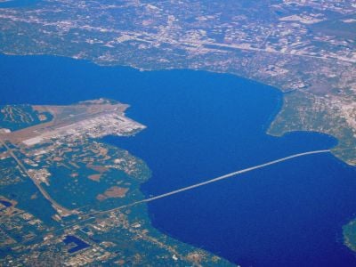
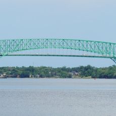
Buckman Bridge, Road bridge across St. Johns River in Jacksonville, Florida.

Description

Buckman Bridge is a road bridge crossing the St. Johns River in Jacksonville and features separate structures for eastbound and westbound traffic on Interstate 295. The twin spans extend about 5 kilometers across the river, connecting the northern and southern shores of this major waterway.

History

The bridge opened to traffic in 1970 after completion of a complex construction project that lasted several years. Its opening changed transportation patterns in Jacksonville by creating a direct crossing over the St. Johns River.

Culture

The bridge is named after Henry Holland Buckman, a politician who shaped Florida's higher education system in the early 1900s. Today it serves as a vital connection for people traveling across the river valley.

Practical

The bridge is part of Interstate 295 and carries many thousands of vehicles daily as a major transportation route. Visitors should expect traffic congestion, especially during morning and evening rush hours when travel times can increase significantly.

Did you know?

During construction, engineers discovered that bacterial activity in the river caused chemical reactions that damaged concrete foundations. This unexpected challenge forced builders to redesign their approach and find new solutions before the bridge could be completed.

Location
Length
4,968.2 m
GPS coordinates
30.19050,-81.66650
Latest update
December 7, 2025 20:42

AroundUs brings together thousands of curated places, local tips, and hidden gems, enriched daily by 60,000 contributors worldwide. Discover all places nearby (Florida).

Around this place
Hart Bridge
United States of America

Hart Bridge

14.4 km
Cummer Museum of Art and Gardens
United States of America

Cummer Museum of Art and Gardens

13.9 km
Riverplace Tower
United States of America

Riverplace Tower

14.4 km
Fuller Warren Bridge
United States of America

Fuller Warren Bridge

13.9 km
Museum of Science & History
United States of America

Museum of Science & History

14.3 km
Memorial Park
United States of America

Memorial Park

13.4 km
Eight Forty One
United States of America

Eight Forty One

14 km
Maple Leaf
United States of America

Maple Leaf

4.1 km
The Peninsula at St. Johns Center
United States of America

The Peninsula at St. Johns Center

14.3 km
Red Bank Plantation
United States of America

Red Bank Plantation

10.5 km
Two Prudential Plaza
United States of America

Two Prudential Plaza

14.2 km
St. Margaret's Episcopal Church and Cemetery
United States of America

St. Margaret's Episcopal Church and Cemetery

14 km
Bryan Gooding Planetarium
United States of America

Bryan Gooding Planetarium

14.3 km
Museum of Southern History
United States of America

Museum of Southern History

11.3 km
Orange Park Elementary School
United States of America

Orange Park Elementary School

4.3 km
Village Store
United States of America

Village Store

9.8 km
River Road Historic District
United States of America

River Road Historic District

3.7 km
Hands on Childrens Museum
United States of America

Hands on Childrens Museum

14.3 km
Orange Park Negro Elementary School
United States of America

Orange Park Negro Elementary School

4.5 km
Holly Cottage
United States of America

Holly Cottage

14.3 km
Lane-Towers House
United States of America

Lane-Towers House

11.8 km
Winterbourne
United States of America

Winterbourne

4 km
Joseph Green House
United States of America

Joseph Green House

4.6 km
South Jacksonville Grammar School
United States of America

South Jacksonville Grammar School

13.4 km
William Helffrich House
United States of America

William Helffrich House

4.1 km
Orange Park, Florida MPS
United States of America

Orange Park, Florida MPS

4.7 km
William Clarke Estate
United States of America

William Clarke Estate

5.5 km
William Westcott House
United States of America

William Westcott House

5.5 km
Show the full map
« Buckman Bridge - Road bridge across St. Johns River in Jacksonville, Florida » is provided by Around Us (aroundus.com). Images and texts are derived from Wikimedia project under a Creative Commons license. You are allowed to copy, distribute, and modify copies of this page, under the conditions set by the license, as long as this note is clearly visible.

Discover hidden gems everywhere you go!

From secret cafés to breathtaking viewpoints, skip the crowded tourist spots and find places that match your style. Our app makes it easy with voice search, smart filtering, route optimization, and insider tips from travelers worldwide. Download now for the complete mobile experience.

Around Us App Screenshot

A unique approach to discovering new places

Le Figaro

All the places worth exploring

France Info

A tailor-made excursion in just a few clicks

20 Minutes

Around Us
Travel Guide & Maps
Download

Send to your phone

QR Code
1

Open the camera app on your mobile.

2

Point at the QR code with your camera. A notification will appear.

3

Tap the notification to open the link.