·

Enable Location

We need your location to show you interesting places around you

Discover nearby places

Find interesting locations and hidden gems around you

Precise directions

Get accurate directions and distances to places

Your location is never shared with other users. It's only used when you tap the location button.

Log in to your account

Start exploring — it's free

Trusted by 62,690 travelers worldwide

Continue with Google
Continue with Apple
or

We will send you a code to connect

By continuing, you accept our Terms and Conditions and our Privacy Policy

Check your inbox

We've sent a pincode in your inbox. Please enter the code below.

Tallahatchee Covered Bridge

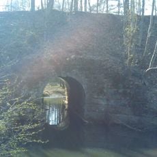
Tallahatchee Covered Bridge, Historical covered bridge in Calhoun County, Alabama.

The Tallahatchee Covered Bridge crosses a waterway near Nances Creek with a span of about 61 feet (19 m). Its construction uses a King-post truss design with a lattice framework supporting the wooden roof structure.

The bridge was built in 1908 and served local farm traffic for decades before a new steel structure took over the crossing in 1954. This shift ended its role as an active transportation route for the surrounding community.

The structure demonstrates how rural communities engineered solutions for crossing water while preserving wooden buildings from the elements. It reflects the practical craftsmanship and problem-solving approach that characterized early 20th century American villages.

The bridge is located approximately 2 miles (3 km) south of Piedmont near State Route 9 and is accessible by car. Parking is limited near the site, so arriving early helps if you plan to explore the surrounding area.

The bridge originally stood in Wellington before being relocated to its current site near Piedmont in 1975. This move was part of a planned pioneer village restoration project designed to preserve the historic structure.

The community of curious travelers

AroundUs brings together thousands of curated places, local tips, and hidden gems, enriched daily by 60,000 contributors worldwide.

Start exploring
Location
GPS coordinates
33.88780,-85.62600
Latest update
December 14, 2025 16:42
Around this place
Weiss Lake
United States of America

Weiss Lake

34.8 km
JSU Stadium
United States of America

JSU Stadium

15 km
Anniston Museum of Natural History
United States of America

Anniston Museum of Natural History

27.9 km
Shoal Creek Church
United States of America

Shoal Creek Church

13.8 km
Parker Memorial Baptist Church
United States of America

Parker Memorial Baptist Church

31.4 km
St. Michael and All Angels Episcopal Church
United States of America

St. Michael and All Angels Episcopal Church

31.8 km
Samuel Noble Monument
United States of America

Samuel Noble Monument

31.6 km
Grace Episcopal Church
United States of America

Grace Episcopal Church

31.6 km
Temple Beth-El
United States of America

Temple Beth-El

31.3 km
John Morgan House
United States of America

John Morgan House

27 km
Saint Paul's Methodist Episcopal Church
United States of America

Saint Paul's Methodist Episcopal Church

31.2 km
Mount Zion Baptist Church
United States of America

Mount Zion Baptist Church

33 km
Calhoun County Courthouse
United States of America

Calhoun County Courthouse

31.8 km
Ross Creek Bridge
United States of America

Ross Creek Bridge

31.5 km
Ten Oaks
United States of America

Ten Oaks

15.4 km
Aderholdt's Mill
United States of America

Aderholdt's Mill

17.7 km
First Presbyterian Church
United States of America

First Presbyterian Church

16.6 km
Union Depot and Freight House
United States of America

Union Depot and Freight House

31.7 km
Kilby House
United States of America

Kilby House

31.1 km
Alexander Woods House
United States of America

Alexander Woods House

14.6 km
Richard P. Huger House
United States of America

Richard P. Huger House

30.7 km
McKleroy-Wilson-Kirby House
United States of America

McKleroy-Wilson-Kirby House

31 km
Crowan Cottage
United States of America

Crowan Cottage

30.9 km
Bank of Anniston
United States of America

Bank of Anniston

31.9 km
Cleburne County Courthouse
United States of America

Cleburne County Courthouse

26.8 km
Berman Museum
United States of America

Berman Museum

27.7 km
Duke's Alley
United States of America

Duke's Alley

30.9 km
World’s Largest Chair
United States of America

World’s Largest Chair

32.3 km
Show the full map
« Tallahatchee Covered Bridge - Historical covered bridge in Calhoun County, Alabama » is provided by Around Us (aroundus.com). Images and texts are derived from Wikimedia project under a Creative Commons license. You are allowed to copy, distribute, and modify copies of this page, under the conditions set by the license, as long as this note is clearly visible.

Discover hidden gems everywhere you go!

From secret cafés to breathtaking viewpoints, skip the crowded tourist spots and find places that match your style. Our app makes it easy with voice search, smart filtering, route optimization, and insider tips from travelers worldwide. Download now for the complete mobile experience.

Around Us App Screenshot

A unique approach to discovering new places

Le Figaro

All the places worth exploring

France Info

A tailor-made excursion in just a few clicks

20 Minutes

Around Us
Travel Guide & Maps
Download

Send to your phone

QR Code
1

Open the camera app on your mobile.

2

Point at the QR code with your camera. A notification will appear.

3

Tap the notification to open the link.