Chest opened
+${chestReward.xp} XP
Explorer
NOUVEAU ×${chestReward.collectible.quantity}
tapez pour fermer
Chest locked

Open chests in the app

Around Us is built for your phone — chests unlock when you walk, explore and capture nearby places.

Enable Location

We need your location to show you interesting places around you

Discover nearby places

Find interesting locations and hidden gems around you

Precise directions

Get accurate directions and distances to places

Your location is never shared with other users. It's only used when you tap the location button.

Saluda River

Log in to your account

Start exploring — it's free

Trusted by 72,880 travelers worldwide

Continue with Google
Continue with Apple
or

We will send you a code to connect

By continuing, you accept our Terms and Conditions and our Privacy Policy

Check your inbox

We've sent a pincode in your inbox. Please enter the code below.

Saluda River
Discussion Reviews 1 Photos
12.7k Popularity

Saluda River, River system in western South Carolina, US

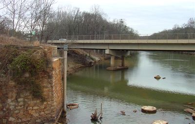
The Saluda River is a river system in western South Carolina that winds through the landscape. It joins the Broad River at Columbia and flows into the Congaree River system.

The construction of Saluda Dam in the 1930s changed large sections of the river and created Lake Murray. Shortly after, the Buzzard Roost Dam was built, forming Lake Greenwood.

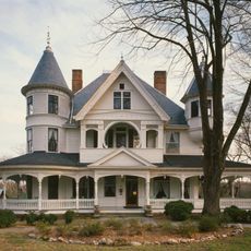
The name comes from an Algonquian-speaking people who settled along these banks in the 1600s. Local communities have long depended on the water for fishing and daily activities.

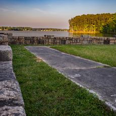
Visitors can explore the river at several points along its course where access from public roads is straightforward. The best time to visit is during drier months when water levels are more stable and conditions are pleasant.

The river forms from two distinct branches, the North and South Saluda, which meet northwest of Greenville. This junction creates an unusual point where water from two different watersheds comes together.

The community of curious travelers

AroundUs brings together thousands of curated places, local tips, and hidden gems, enriched daily by 60,000 contributors worldwide.

Start exploring
GPS coordinates
34.25945,-82.02596
Latest update
December 7, 2025 20:43
Around this place
John Calvin Owings House
United States of America

John Calvin Owings House

26.1 km
Lake Greenwood State Park
United States of America

Lake Greenwood State Park

10.1 km
Albright-Dukes House
United States of America

Albright-Dukes House

25.7 km
Barratt House
United States of America

Barratt House

19.1 km
Webb-Coleman House
United States of America

Webb-Coleman House

20.9 km
Lander College Old Main Building
United States of America

Lander College Old Main Building

14.4 km
William Dunlap Simpson House
United States of America

William Dunlap Simpson House

26.3 km
Vance-Maxwell House
United States of America

Vance-Maxwell House

14.2 km
Kinard House
United States of America

Kinard House

9.5 km
Stony Point
United States of America

Stony Point

9.4 km
James C. Self House
United States of America

James C. Self House

16.1 km
Masonic Female College and Cokesbury Conference School
United States of America

Masonic Female College and Cokesbury Conference School

17.7 km
Old Greenwood High School
United States of America

Old Greenwood High School

14.7 km
J. Wesley Brooks House
United States of America

J. Wesley Brooks House

16.5 km
Charles H. Duckett House
United States of America

Charles H. Duckett House

26.3 km
Sunnyside
United States of America

Sunnyside

14.3 km
Dr. William Claudius Irby House
United States of America

Dr. William Claudius Irby House

26.1 km
Irby-Henderson-Todd House
United States of America

Irby-Henderson-Todd House

25.8 km
Allen Dial House
United States of America

Allen Dial House

25.2 km
Moon-Dominick House
United States of America

Moon-Dominick House

17.2 km
Lyde Irby Darlington House
United States of America

Lyde Irby Darlington House

26.2 km
Moore-Kinard House
United States of America

Moore-Kinard House

19.1 km
Nickels-Milam House
United States of America

Nickels-Milam House

18.7 km
The Oaks
United States of America

The Oaks

5.4 km
South Harper Historic District
United States of America

South Harper Historic District

25.9 km
Sitgreaves House
United States of America

Sitgreaves House

25.6 km
Wilson-Clary House
United States of America

Wilson-Clary House

26.2 km
Greenwood Museum
United States of America

Greenwood Museum

14.5 km
Show the full map
Reviews
Share your experience

No review yet

Discussions
Start a discussion...

No discussion yet

« Saluda River - River system in western South Carolina, US » is provided by Around Us (aroundus.com). Images and texts are derived from Wikimedia project under a Creative Commons license. You are allowed to copy, distribute, and modify copies of this page, under the conditions set by the license, as long as this note is clearly visible.

Discover hidden gems everywhere you go!

From secret cafés to breathtaking viewpoints, skip the crowded tourist spots and find places that match your style. Our app makes it easy with voice search, smart filtering, route optimization, and insider tips from travelers worldwide. Download now for the complete mobile experience.

Around Us App Screenshot

A unique approach to discovering new places

Le Figaro

All the places worth exploring

France Info

A tailor-made excursion in just a few clicks

20 Minutes

Around Us
Travel Guide & Maps
Download

Send to your phone

QR Code
1

Open the camera app on your mobile.

2

Point at the QR code with your camera. A notification will appear.

3

Tap the notification to open the link.