Enable Location

We need your location to show you interesting places around you

Discover nearby places

Find interesting locations and hidden gems around you

Precise directions

Get accurate directions and distances to places

Your location is never shared with other users. It's only used when you tap the location button.

Log in to your account

Start exploring — it's free

Trusted by 67,256 travelers worldwide

Continue with Google
Continue with Apple
or

We will send you a code to connect

By continuing, you accept our Terms and Conditions and our Privacy Policy

Check your inbox

We've sent a pincode in your inbox. Please enter the code below.

Dreher Island State Recreation Area
Discussion Reviews Photo
3.8k Popularity

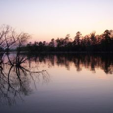
Dreher Island State Recreation Area, State recreation area in Lake Murray, South Carolina.

Dreher Island State Recreation Area is a public park in South Carolina, spread across three islands in Lake Murray that are connected to each other and to the mainland by causeways. The park offers tent and RV campsites, rental cabins, boat launches, and picnic areas split across the different islands.

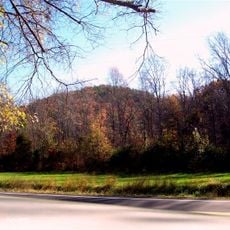
The park opened in 1990, when South Carolina was expanding public recreation areas around Lake Murray's shoreline. The three-island layout was developed to meet growing demand for outdoor access in the area.

The park draws anglers who fish for striped bass and largemouth bass in Lake Murray, and fishing is very much part of the daily rhythm here. Locals and visitors alike bring their own rods and often spend the whole morning along the shoreline or out on the water.

Getting around between campsites, boat launches, and picnic areas requires driving across the causeways, so a car is useful even once you are inside the park. Plan for at least half a day if you want to explore more than one island.

Lake Murray itself is a man-made reservoir created in the 1930s, which means the three islands were originally hilltops in the surrounding landscape before the valley was flooded. This origin gives the park its fragmented shape, with water running between land sections that were once connected to each other.

The community of curious travelers

AroundUs brings together thousands of curated places, local tips, and hidden gems, enriched daily by 60,000 contributors worldwide.

Start exploring
Location
Inception
1990
GPS coordinates
34.08220,-81.40360
Latest update
March 3, 2026 14:03
Around this place
Lake Murray
United States of America

Lake Murray

7.1 km
Little Mountain
United States of America

Little Mountain

11.7 km
W. Q. M. Berly House
United States of America

W. Q. M. Berly House

18.3 km
Lexington County Courthouse
United States of America

Lexington County Courthouse

19.1 km
St. John's Lutheran Church
United States of America

St. John's Lutheran Church

19.2 km
Pomaria
United States of America

Pomaria

19.2 km
Ballentine-Shealy House
United States of America

Ballentine-Shealy House

3.2 km
Fox House
United States of America

Fox House

18.5 km
Jacob Wingard Dreher House
United States of America

Jacob Wingard Dreher House

15.1 km
Home National Bank
United States of America

Home National Bank

19.1 km
John Jacob Calhoun Koon Farmstead
United States of America

John Jacob Calhoun Koon Farmstead

18.5 km
Lemuel Boozer House
United States of America

Lemuel Boozer House

18.4 km
Lexington County Museum
United States of America

Lexington County Museum

18.4 km
Robinson-Hiller House
United States of America

Robinson-Hiller House

10.3 km
C.E. Corley House
United States of America

C.E. Corley House

20.3 km
Jacob Bedenbaugh House
United States of America

Jacob Bedenbaugh House

17.3 km
Charlton Rauch House
United States of America

Charlton Rauch House

18.6 km
Bank of Western Carolina
United States of America

Bank of Western Carolina

19.1 km
D. D. D. Barr House
United States of America

D. D. D. Barr House

19.8 km
David Rawl House
United States of America

David Rawl House

18.8 km
Folk-Holloway House
United States of America

Folk-Holloway House

20.7 km
Church Street Historic District
United States of America

Church Street Historic District

20.5 km
John Solomon Hendrix House
United States of America

John Solomon Hendrix House

13.9 km
Rev. Frank Yarborough House
United States of America

Rev. Frank Yarborough House

20.3 km
William Berly House
United States of America

William Berly House

18.3 km
Ernest L. Hazelius House
United States of America

Ernest L. Hazelius House

18.4 km
Maj. Henry A. Meetze House
United States of America

Maj. Henry A. Meetze House

20.1 km
Simmons-Harth House
United States of America

Simmons-Harth House

19.1 km
Show the full map
Reviews
Share your experience

No review yet

Discussions
Start a discussion...

No discussion yet

« Dreher Island State Recreation Area - State recreation area in Lake Murray, South Carolina » is provided by Around Us (aroundus.com). Images and texts are derived from Wikimedia project under a Creative Commons license. You are allowed to copy, distribute, and modify copies of this page, under the conditions set by the license, as long as this note is clearly visible.

Discover hidden gems everywhere you go!

From secret cafés to breathtaking viewpoints, skip the crowded tourist spots and find places that match your style. Our app makes it easy with voice search, smart filtering, route optimization, and insider tips from travelers worldwide. Download now for the complete mobile experience.

Around Us App Screenshot

A unique approach to discovering new places

Le Figaro

All the places worth exploring

France Info

A tailor-made excursion in just a few clicks

20 Minutes

Around Us
Travel Guide & Maps
Download

Send to your phone

QR Code
1

Open the camera app on your mobile.

2

Point at the QR code with your camera. A notification will appear.

3

Tap the notification to open the link.