Enable Location

We need your location to show you interesting places around you

Discover nearby places

Find interesting locations and hidden gems around you

Precise directions

Get accurate directions and distances to places

Your location is never shared with other users. It's only used when you tap the location button.

Marion High School

Log in to your account

Start exploring — it's free

Trusted by 62,050 travelers worldwide

Continue with Google
Continue with Apple
or

We will send you a code to connect

By continuing, you accept our Terms and Conditions and our Privacy Policy

Check your inbox

We've sent a pincode in your inbox. Please enter the code below.

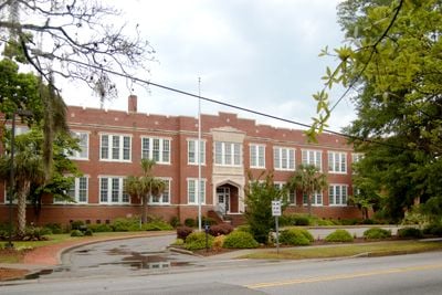
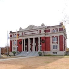
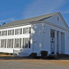
Marion High School, Educational building in Marion, South Carolina, United States.

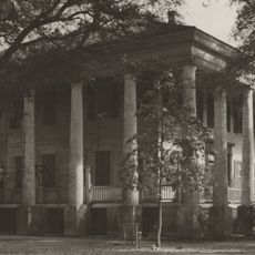
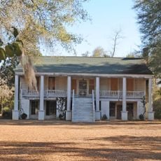
Marion High School is a school building in Marion built in the early 1900s with Classical Revival design elements. The structure displays prominent columns, wide staircases, and large windows that define its architectural character.

The building was constructed during an era when Classical Revival forms shaped American school architecture. Its construction methods and design earned recognition on the National Register of Historic Places for representing early twentieth-century building practices.

The school building has served as a gathering place where Marion residents meet for events and programs. Multiple generations of locals have created memories within its walls.

The building undergoes regular maintenance and restoration work to preserve its original elements. Visitors should plan ahead and be aware that portions of the structure may occasionally be unavailable due to ongoing care and updates.

The school preserves a collection of historical photographs and artifacts that document education's development in Marion County. These items tell stories of student and teacher generations who passed through its doors.

The community of curious travelers

AroundUs brings together thousands of curated places, local tips, and hidden gems, enriched daily by 60,000 contributors worldwide.

Start exploring
Location
GPS coordinates
34.18500,-79.40140
Latest update
December 14, 2025 18:06
Around this place
Lumber River
United States of America

Lumber River

54.2 km
Florence National Cemetery
United States of America

Florence National Cemetery

32.5 km
Smith Tobacco Barn
United States of America

Smith Tobacco Barn

22.2 km
Cotton Press
United States of America

Cotton Press

20.4 km
Slave Houses, Gregg Plantation
United States of America

Slave Houses, Gregg Plantation

23 km
Rankin-Harwell House
United States of America

Rankin-Harwell House

24.1 km
Roseville Plantation
United States of America

Roseville Plantation

29.4 km
Galivants Ferry Historic District
United States of America

Galivants Ferry Historic District

20.8 km
Dillon County Courthouse
United States of America

Dillon County Courthouse

26.1 km
St. Paul's Methodist Church
United States of America

St. Paul's Methodist Church

32.5 km
Dillon Downtown Historic District
United States of America

Dillon Downtown Historic District

17.2 km
James W. Dillon House
United States of America

James W. Dillon House

26.1 km
Red Doe
United States of America

Red Doe

22.7 km
Christ Episcopal Church
United States of America

Christ Episcopal Church

20.2 km
Latta Historic District No. 1
United States of America

Latta Historic District No. 1

17.5 km
James W. Hamer House
United States of America

James W. Hamer House

31.7 km
Claussen House
United States of America

Claussen House

21.1 km
Hopewell Presbyterian Church and Hopewell Cemetery
United States of America

Hopewell Presbyterian Church and Hopewell Cemetery

21.4 km
McMillan House
United States of America

McMillan House

17.2 km
Dillard Barn
United States of America

Dillard Barn

15.4 km
Mt. Zion Rosenwald School
United States of America

Mt. Zion Rosenwald School

22.3 km
Latta Historic District No. 2
United States of America

Latta Historic District No. 2

17.3 km
Blooming Grove
United States of America

Blooming Grove

30.2 km
Mullins Commercial Historic District
United States of America

Mullins Commercial Historic District

13.6 km
John Hayes Farmstead
United States of America

John Hayes Farmstead

20.4 km
Gregg-Wallace Farm Tenant House
United States of America

Gregg-Wallace Farm Tenant House

23.1 km
Selkirk Farm
United States of America

Selkirk Farm

32.9 km
J.C. Teasley House
United States of America

J.C. Teasley House

13.8 km
Show the full map
« Marion High School - Educational building in Marion, South Carolina, United States » is provided by Around Us (aroundus.com). Images and texts are derived from Wikimedia project under a Creative Commons license. You are allowed to copy, distribute, and modify copies of this page, under the conditions set by the license, as long as this note is clearly visible.

Discover hidden gems everywhere you go!

From secret cafés to breathtaking viewpoints, skip the crowded tourist spots and find places that match your style. Our app makes it easy with voice search, smart filtering, route optimization, and insider tips from travelers worldwide. Download now for the complete mobile experience.

Around Us App Screenshot

A unique approach to discovering new places

Le Figaro

All the places worth exploring

France Info

A tailor-made excursion in just a few clicks

20 Minutes

Around Us
Travel Guide & Maps
Download

Send to your phone

QR Code
1

Open the camera app on your mobile.

2

Point at the QR code with your camera. A notification will appear.

3

Tap the notification to open the link.