Lumber River

Log in to your account

AroundUs is a community-driven map of interesting places, built by curious explorers like you. It grows with every review, story, and photo you share.
Connect to save your favorite spots, contribute locations, and create personalized routes.
Continue with Google
Continue with Apple
Continue with X
Continue with Facebook
Continue with email
By continuing, you accept our Terms and Conditions and our Privacy Policy
Create an account
Add to collection
Map
Suggest a change
Share

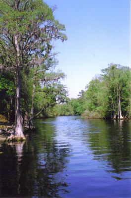
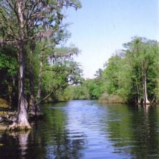
Lumber River, Natural watercourse in south-central North Carolina, United States.

Lumber River is a waterway in south-central North Carolina that winds through flat terrain for over 130 miles. It originates from Drowning Creek in the inland areas and eventually flows into the Little Pee Dee River system.

Early English surveyors called it Drowning Creek, but the North Carolina legislature renamed it Lumber River in 1809 to reflect the region's timber industry. This change in name marked a shift toward recognizing the economic importance of the area.

Archaeological excavations along the river uncovered Native American artifacts, including a dugout canoe dating back more than 1,025 years.

Multiple boat access points are spread along the river, allowing visitors to reach different sections of Lumber River State Park. Water levels and conditions vary seasonally, so it is wise to check local conditions before planning a visit.

Archaeological discoveries along the banks have revealed remnants of indigenous life, including a hollowed canoe carved more than a thousand years ago. These findings show that people have navigated these waters for millennia.

GPS coordinates: 34.61311,-79.11924

Latest update: December 7, 2025 20:45

Photos
Around this place
South of the Border
United States of America

South of the Border

21.7 km
Lumber River State Park
United States of America

Lumber River State Park

27.1 km
Smith Tobacco Barn
United States of America

Smith Tobacco Barn

32.5 km
Cotton Press
United States of America

Cotton Press

48.1 km
Slave Houses, Gregg Plantation
United States of America

Slave Houses, Gregg Plantation

47.1 km
Rankin-Harwell House
United States of America

Rankin-Harwell House

42.5 km
Galivants Ferry Historic District
United States of America

Galivants Ferry Historic District

63.7 km
Marion High School
United States of America

Marion High School

54.2 km
Dillon County Courthouse
United States of America

Dillon County Courthouse

32 km
St. Paul's Methodist Church
United States of America

St. Paul's Methodist Church

30 km
Dillon Downtown Historic District
United States of America

Dillon Downtown Historic District

42 km
James W. Dillon House
United States of America

James W. Dillon House

31.9 km
Centenary Methodist Church
United States of America

Centenary Methodist Church

18.1 km
Christ Episcopal Church
United States of America

Christ Episcopal Church

41.8 km
Hamer Hall
United States of America

Hamer Hall

23.7 km
Latta Historic District No. 1
United States of America

Latta Historic District No. 1

41.9 km
John P. Derham House
United States of America

John P. Derham House

56 km
James W. Hamer House
United States of America

James W. Hamer House

31.2 km
H.W. Ambrose House
United States of America

H.W. Ambrose House

85.5 km
McMillan House
United States of America

McMillan House

42.3 km
Dillard Barn
United States of America

Dillard Barn

50.7 km
Latta Historic District No. 2
United States of America

Latta Historic District No. 2

41.8 km
Mullins Commercial Historic District
United States of America

Mullins Commercial Historic District

47.3 km
John Hayes Farmstead
United States of America

John Hayes Farmstead

48.2 km
Rowland Main Street Historic District
United States of America

Rowland Main Street Historic District

18.1 km
W.R. Surles Memorial Library
United States of America

W.R. Surles Memorial Library

16.9 km
J.C. Teasley House
United States of America

J.C. Teasley House

46.8 km
Marion Historic District
United States of America

Marion Historic District

54.8 km
Show the full map
Reviews

Visited this place? Tap the stars to rate it and share your experience / photos with the community! Try now! You can cancel it anytime.

« Lumber River - Natural watercourse in south-central North Carolina, United States » is provided by Around Us (aroundus.com). Images and texts are derived from Wikimedia project under a Creative Commons license. You are allowed to copy, distribute, and modify copies of this page, under the conditions set by the license, as long as this note is clearly visible.

Discover hidden gems everywhere you go!

From secret cafés to breathtaking viewpoints, skip the crowded tourist spots and find places that match your style. Our app makes it easy with voice search, smart filtering, route optimization, and insider tips from travelers worldwide. Download now for the complete mobile experience.

Around Us App Screenshot

A unique approach to discovering new places

Le Figaro

All the places worth exploring

France Info

A tailor-made excursion in just a few clicks

20 Minutes