Chest opened
+${chestReward.xp} XP
Explorer
NOUVEAU ×${chestReward.collectible.quantity}
tapez pour fermer
Chest locked

Open chests in the app

Around Us is built for your phone — chests unlock when you walk, explore and capture nearby places.

Enable Location

We need your location to show you interesting places around you

Discover nearby places

Find interesting locations and hidden gems around you

Precise directions

Get accurate directions and distances to places

Your location is never shared with other users. It's only used when you tap the location button.

Log in to your account

Start exploring — it's free

Trusted by 72,990 travelers worldwide

Continue with Google
Continue with Apple
or

We will send you a code to connect

By continuing, you accept our Terms and Conditions and our Privacy Policy

Check your inbox

We've sent a pincode in your inbox. Please enter the code below.

Cypress Street Viaduct
Discussion Reviews Photo
40.8k Popularity

Cypress Street Viaduct, Former highway in California

The Cypress Street Viaduct was a double-deck freeway in Oakland that carried traffic above the city streets. The concrete and steel structure was built to handle the growing number of vehicles moving through the region.

The viaduct opened in 1957 as part of the nation's expanding freeway system. It collapsed on October 17, 1989, during the Loma Prieta earthquake, resulting in significant loss of life and prompting major changes in how such structures are built.

Its collapse forced a reevaluation of US urban highway design and engineering.

The site is no longer accessible as a standing structure, since the viaduct no longer exists. Today, the area has been redesigned and transformed into a tree-lined boulevard that you can walk through.

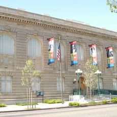
A preserved section of the original structure is on display at the Oakland Museum of California, showing what it looked like up close. This piece serves as a stark reminder of both the engineering and the fragility of such massive roadways.

The community of curious travelers

AroundUs brings together thousands of curated places, local tips, and hidden gems, enriched daily by 60,000 contributors worldwide.

Start exploring
Location
GPS coordinates
37.81680,-122.28900
Latest update
December 8, 2025 08:20
Around this place
USS Potomac
United States of America

USS Potomac

2.5 km
Fox Oakland Theatre
United States of America

Fox Oakland Theatre

2 km
Paramount Theatre
United States of America

Paramount Theatre

2 km
Emeryville Shellmound
United States of America

Emeryville Shellmound

1.9 km
Tribune Tower
United States of America

Tribune Tower

2.2 km
Kaiser Center
United States of America

Kaiser Center

2.4 km
Ordway Building
United States of America

Ordway Building

2.3 km
Oakland City Hall
United States of America

Oakland City Hall

2 km
Museum of Art and Digital Entertainment
United States of America

Museum of Art and Digital Entertainment

2.1 km
California Hotel
United States of America

California Hotel

1.4 km
Emeryville Crescent State Marine Reserve
United States of America

Emeryville Crescent State Marine Reserve

2.3 km
Ronald V. Dellums Federal Building
United States of America

Ronald V. Dellums Federal Building

1.8 km
African American Museum and Library at Oakland
United States of America

African American Museum and Library at Oakland

1.6 km
Clorox Building
United States of America

Clorox Building

2.1 km
Cathedral Building
United States of America

Cathedral Building

2 km
Pardee Home
United States of America

Pardee Home

1.7 km
Cathedral of Saint Francis de Sales
United States of America

Cathedral of Saint Francis de Sales

1.6 km
555 City Center
United States of America

555 City Center

1.9 km
United States lightship Relief
United States of America

United States lightship Relief

2.5 km
Bank of America Building
United States of America

Bank of America Building

2.1 km
I. Magnin Building
United States of America

I. Magnin Building

2 km
10th Street Market
United States of America

10th Street Market

2.1 km
Lake Merritt Plaza
United States of America

Lake Merritt Plaza

2.3 km
Kaiser Engineering Building
United States of America

Kaiser Engineering Building

2.4 km
Elihu M. Harris State Office Building
United States of America

Elihu M. Harris State Office Building

1.7 km
Greek Orthodox Church of the Assumption
United States of America

Greek Orthodox Church of the Assumption

1.7 km
Oakland Asian Cultural Center
United States of America

Oakland Asian Cultural Center

2.2 km
African American Museum and Library at Oakland
United States of America

African American Museum and Library at Oakland

1.6 km
Show the full map
Reviews
Share your experience

No review yet

Discussions
Start a discussion...

No discussion yet

« Cypress Street Viaduct - Former highway in California » is provided by Around Us (aroundus.com). Images and texts are derived from Wikimedia project under a Creative Commons license. You are allowed to copy, distribute, and modify copies of this page, under the conditions set by the license, as long as this note is clearly visible.

Discover hidden gems everywhere you go!

From secret cafés to breathtaking viewpoints, skip the crowded tourist spots and find places that match your style. Our app makes it easy with voice search, smart filtering, route optimization, and insider tips from travelers worldwide. Download now for the complete mobile experience.

Around Us App Screenshot

A unique approach to discovering new places

Le Figaro

All the places worth exploring

France Info

A tailor-made excursion in just a few clicks

20 Minutes

Around Us
Travel Guide & Maps
Download

Send to your phone

QR Code
1

Open the camera app on your mobile.

2

Point at the QR code with your camera. A notification will appear.

3

Tap the notification to open the link.