Lava Beds National Monument

Log in to your account

AroundUs is a community-driven map of interesting places, built by curious explorers like you. It grows with every review, story, and photo you share.
Connect to save your favorite spots, contribute locations, and create personalized routes.
By continuing, you accept our Terms and Conditions and our Privacy Policy
Add to collection
Map
Suggest a change
Share

Lava Beds National Monument, National park in Modoc County, California, United States.

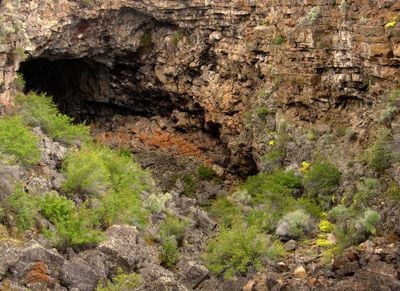
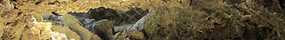
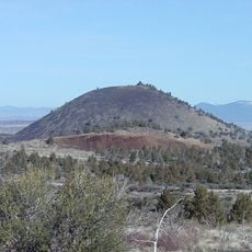
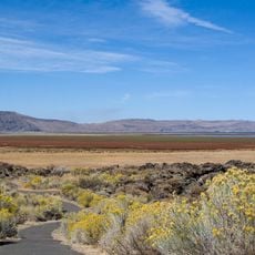
Lava Beds National Monument is a nature reserve in northern California featuring more than 800 caves formed by ancient volcanic flows from Medicine Lake Volcano. The landscape displays distinctive volcanic features including lava falls, crater lakes, and lava flows that create a stark and dramatic terrain.

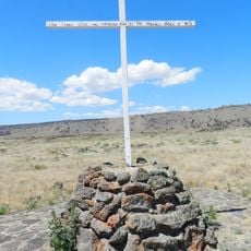
The monument was the battleground of the Modoc War from 1872-1873, when Native American warriors fought to defend their territory against the United States Army. This conflict shaped the region's history and left marks that visitors can still observe today.

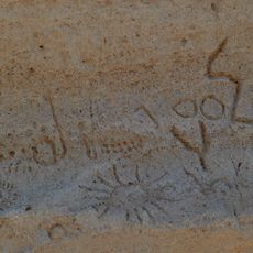
Petroglyph Point displays rock carvings made by Native Americans over many centuries, showing how indigenous people used and valued this land. Visitors can walk among these ancient markings and understand the deep connection that tribal communities had to the area.

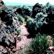
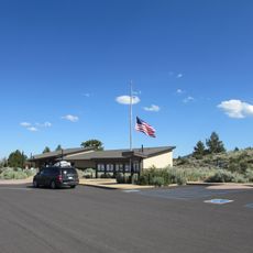
The visitor center offers safety information, cave maps, and flashlight rentals to help with exploration of the tunnel network. Wear sturdy shoes and bring plenty of water, as hiking can be strenuous and shade is limited across the terrain.

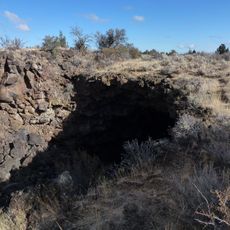
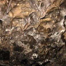
The caves maintain constant temperatures around 55 degrees Fahrenheit (13 degrees Celsius) throughout the year, supporting rare ice crystal formations and specialized bat populations. This underground world offers glimpses into an ecosystem found in few other places.

Location: Siskiyou County

Location: Modoc County

Inception: November 21, 1925

Operator: National Park Service

Website: https://nps.gov/labe

GPS coordinates: 41.71389,-121.50833

Latest update: December 6, 2025 22:04

Around this place
Show the full map
Medicine Lake Volcano
United States of America

Medicine Lake Volcano

16.5 km
Modoc National Forest
United States of America

Modoc National Forest

37.5 km
Captain Jack's Stronghold
United States of America

Captain Jack's Stronghold

12 km
Lower Klamath National Wildlife Refuge
United States of America

Lower Klamath National Wildlife Refuge

36.2 km
Link River Dam
United States of America

Link River Dam

62.8 km
Tule Lake National Wildlife Refuge
United States of America

Tule Lake National Wildlife Refuge

26.3 km
OC&E Woods Line State Trail
United States of America

OC&E Woods Line State Trail

58.5 km
Clear Lake National Wildlife Refuge
United States of America

Clear Lake National Wildlife Refuge

36.8 km
Lake Ewauna
United States of America

Lake Ewauna

59.9 km
Petroglyph Point Archaeological Site
United States of America

Petroglyph Point Archaeological Site

17.5 km
Bear Valley National Wildlife Refuge
United States of America

Bear Valley National Wildlife Refuge

49.6 km
Schonchin Butte
United States of America

Schonchin Butte

3.2 km
Klamath Basin National Wildlife Refuge Complex
United States of America

Klamath Basin National Wildlife Refuge Complex

26.3 km
Gerber Reservoir
United States of America

Gerber Reservoir

63.6 km
Canby's Cross
United States of America

Canby's Cross

12 km
Rainbow Mountain
United States of America

Rainbow Mountain

45.9 km
Klamath Falls City Hall
United States of America

Klamath Falls City Hall

61 km
Judge Henry L. Benson House
United States of America

Judge Henry L. Benson House

61.2 km
Richardson–Ulrich House
United States of America

Richardson–Ulrich House

61.4 km
Tule Lake National Monument
United States of America

Tule Lake National Monument

22.5 km
Schonchin Butte Lookout
United States of America

Schonchin Butte Lookout

3.2 km
Klamath County Museum
United States of America

Klamath County Museum

61.4 km
Skull Cave
United States of America

Skull Cave

2 km
Mushpot Cave
United States of America

Mushpot Cave

43 m
Hospital Rock Trail
United States of America

Hospital Rock Trail

13.7 km
Lava Beds Visitor Center
United States of America

Lava Beds Visitor Center

117 m
Ross Ragland Theatre
United States of America

Ross Ragland Theatre

61.4 km
Timber Mountain Lookout
United States of America

Timber Mountain Lookout

19.9 km
Show the full map

Reviews

Visited this place? Tap the stars to rate it and share your experience / photos with the community! Try now! You can cancel it anytime.

« Lava Beds National Monument - National park in Modoc County, California, United States » is provided by Around Us (aroundus.com). Images and texts are derived from Wikimedia project under a Creative Commons license. You are allowed to copy, distribute, and modify copies of this page, under the conditions set by the license, as long as this note is clearly visible.

Discover hidden gems everywhere you go!

From secret cafés to breathtaking viewpoints, skip the crowded tourist spots and find places that match your style. Our app makes it easy with voice search, smart filtering, route optimization, and insider tips from travelers worldwide. Download now for the complete mobile experience.

Around Us App Screenshot

A unique approach to discovering new places

Le Figaro

All the places worth exploring

France Info

A tailor-made excursion in just a few clicks

20 Minutes