Enable Location

We need your location to show you interesting places around you

Discover nearby places

Find interesting locations and hidden gems around you

Precise directions

Get accurate directions and distances to places

Your location is never shared with other users. It's only used when you tap the location button.

Pulpit Rock

Log in to your account

Start exploring — it's free

Trusted by 63,043 travelers worldwide

Continue with Google
Continue with Apple
or

We will send you a code to connect

By continuing, you accept our Terms and Conditions and our Privacy Policy

Check your inbox

We've sent a pincode in your inbox. Please enter the code below.

Pulpit Rock
Discussion Reviews 1 Photos
1.8k Popularity

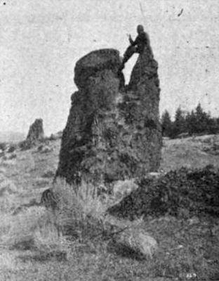
Pulpit Rock, Rock formation in The Dalles, US

Pulpit Rock is a natural stone formation that stands approximately 12 feet (3.7 meters) tall at the intersection of Court Street and East 12th Street in a residential neighborhood. The elevated platform rises distinctly above street level and features an information sign explaining its background.

The formation was used by Methodist missionaries in the 1840s as a preaching location at the Wascopam Mission. It served as a central point where religious messages were delivered to the indigenous peoples of the region.

The rock served as a gathering place where different religious groups met and shared their beliefs with one another. It represents the early encounters between missionaries and local people who gathered at this shared location.

The formation sits in a regular residential neighborhood at a street intersection and is freely accessible to visitors. An informational sign at the location explains its history, making a visit straightforward.

The city built streets around the formation and left it in its original position rather than removing it. This makes it a rare example of how a community preserved a geological feature by working around it during urban development.

The community of curious travelers

AroundUs brings together thousands of curated places, local tips, and hidden gems, enriched daily by 60,000 contributors worldwide.

Start exploring
Location
GPS coordinates
45.59560,-121.18900
Latest update
December 14, 2025 12:23
Around this place
The Dalles Bridge
United States of America

The Dalles Bridge

4.2 km
The Dalles Mint
United States of America

The Dalles Mint

985 m
Old St. Peter's Landmark
United States of America

Old St. Peter's Landmark

804 m
Granada Theater
United States of America

Granada Theater

862 m
Rorick House Museum
United States of America

Rorick House Museum

360 m
Bennett–Williams House
United States of America

Bennett–Williams House

831 m
Dr. J. A. Reuter House
United States of America

Dr. J. A. Reuter House

486 m
Anderson Homestead
United States of America

Anderson Homestead

693 m
The Dalles Civic Auditorium
United States of America

The Dalles Civic Auditorium

699 m
Hugh Glenn House
United States of America

Hugh Glenn House

267 m
Original Wasco County Courthouse
United States of America

Original Wasco County Courthouse

892 m
The Dalles Carnegie Library
United States of America

The Dalles Carnegie Library

677 m
Joseph D. and Margaret Kelly House
United States of America

Joseph D. and Margaret Kelly House

880 m
U.S. Post Office
United States of America

U.S. Post Office

827 m
Edward French House
United States of America

Edward French House

675 m
John and Murta Van Dellen House
United States of America

John and Murta Van Dellen House

438 m
Heimrich–Seufert House
United States of America

Heimrich–Seufert House

303 m
John L. Thompson House
United States of America

John L. Thompson House

824 m
Sharp Family Residential Ensemble
United States of America

Sharp Family Residential Ensemble

767 m
Fulton–Taylor House
United States of America

Fulton–Taylor House

472 m
Orlando Humason House
United States of America

Orlando Humason House

281 m
Fort Dalles Museum and Anderson Homestead
United States of America

Fort Dalles Museum and Anderson Homestead

646 m
National Neon Sign Museum
United States of America

National Neon Sign Museum

732 m
Sunshine Mill
United States of America

Sunshine Mill

1.4 km
Fort Dalles Surgeon's Quarters
United States of America

Fort Dalles Surgeon's Quarters

651 m
Fort Dalles Museum
United States of America

Fort Dalles Museum

693 m
Wonderworks Children’s Museum
United States of America

Wonderworks Children’s Museum

1.1 km
Mill Creek Bridge
United States of America

Mill Creek Bridge

907 m
Show the full map
Reviews
Share your experience

No review yet

Discussions
Start a discussion...

No discussion yet

« Pulpit Rock - Rock formation in The Dalles, US » is provided by Around Us (aroundus.com). Images and texts are derived from Wikimedia project under a Creative Commons license. You are allowed to copy, distribute, and modify copies of this page, under the conditions set by the license, as long as this note is clearly visible.

Discover hidden gems everywhere you go!

From secret cafés to breathtaking viewpoints, skip the crowded tourist spots and find places that match your style. Our app makes it easy with voice search, smart filtering, route optimization, and insider tips from travelers worldwide. Download now for the complete mobile experience.

Around Us App Screenshot

A unique approach to discovering new places

Le Figaro

All the places worth exploring

France Info

A tailor-made excursion in just a few clicks

20 Minutes

Around Us
Travel Guide & Maps
Download

Send to your phone

QR Code
1

Open the camera app on your mobile.

2

Point at the QR code with your camera. A notification will appear.

3

Tap the notification to open the link.