Enable Location

We need your location to show you interesting places around you

Discover nearby places

Find interesting locations and hidden gems around you

Precise directions

Get accurate directions and distances to places

Your location is never shared with other users. It's only used when you tap the location button.

The Dalles Bridge

Log in to your account

Start exploring — it's free

Trusted by 66,061 travelers worldwide

Continue with Google
Continue with Apple
or

We will send you a code to connect

By continuing, you accept our Terms and Conditions and our Privacy Policy

Check your inbox

We've sent a pincode in your inbox. Please enter the code below.

The Dalles Bridge
Discussion Reviews 1 Photos
3.2k Popularity

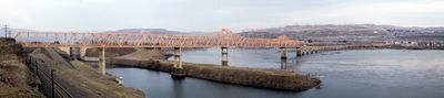
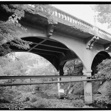
The Dalles Bridge, Steel cantilever truss bridge across Columbia River between The Dalles, Oregon and Dallesport, Washington, United States.

The Dalles Bridge is a steel cantilever truss bridge crossing the Columbia River between The Dalles, Oregon, and Dallesport, Washington. It carries US Route 197 and links Interstate 84 on the Oregon side with Washington State Route 14 on the north bank.

A ferry had been carrying people across the river at this spot since 1854, but the bridge did not open until 1953 after decades of planning. Dam construction on this stretch of the Columbia was already underway and shaped how the project was carried out.

The name comes from the French word "dalle", used by early fur traders to describe the rocky narrows of the Columbia River in this area. Anyone crossing today can still see the wide rocky walls along the river that gave the place its name.

The bridge is easy to cross by car as part of a main route between Oregon and Washington, and signs along Interstate 84 guide drivers directly toward it. Those coming from the Washington side follow State Route 14 west to reach the crossing without going through any town center.

During construction, engineers used prefabricated steel parts originally intended for other projects, partly because dam development on the river was happening at the same time and affected material availability. The result was a structure that quietly absorbed the constraints of two overlapping infrastructure projects.

The community of curious travelers

AroundUs brings together thousands of curated places, local tips, and hidden gems, enriched daily by 60,000 contributors worldwide.

Start exploring
Location
Location
Inception
1953
Official opening
December 18, 1953
GPS coordinates
45.61010,-121.13900
Latest update
March 3, 2026 13:56
Around this place
Pacific DC Intertie
United States of America

Pacific DC Intertie

2.6 km
The Dalles Dam
United States of America

The Dalles Dam

589 m
Celilo Converter Station
United States of America

Celilo Converter Station

2.7 km
The Dalles Mint
United States of America

The Dalles Mint

3.2 km
Pulpit Rock
United States of America

Pulpit Rock

4.2 km
Old St. Peter's Landmark
United States of America

Old St. Peter's Landmark

3.9 km
Granada Theater
United States of America

Granada Theater

3.5 km
Rorick House Museum
United States of America

Rorick House Museum

4.5 km
Bennett–Williams House
United States of America

Bennett–Williams House

4.3 km
Dr. J. A. Reuter House
United States of America

Dr. J. A. Reuter House

3.7 km
Indian Shaker Church and Gulick Homestead
United States of America

Indian Shaker Church and Gulick Homestead

645 m
The Dalles Civic Auditorium
United States of America

The Dalles Civic Auditorium

3.5 km
Hugh Glenn House
United States of America

Hugh Glenn House

4.1 km
Original Wasco County Courthouse
United States of America

Original Wasco County Courthouse

3.9 km
The Dalles Carnegie Library
United States of America

The Dalles Carnegie Library

3.6 km
Joseph D. and Margaret Kelly House
United States of America

Joseph D. and Margaret Kelly House

3.4 km
U.S. Post Office
United States of America

U.S. Post Office

3.7 km
Edward French House
United States of America

Edward French House

3.9 km
John and Murta Van Dellen House
United States of America

John and Murta Van Dellen House

3.8 km
Heimrich–Seufert House
United States of America

Heimrich–Seufert House

3.9 km
John L. Thompson House
United States of America

John L. Thompson House

3.8 km
Sharp Family Residential Ensemble
United States of America

Sharp Family Residential Ensemble

3.5 km
Fulton–Taylor House
United States of America

Fulton–Taylor House

3.8 km
Orlando Humason House
United States of America

Orlando Humason House

4 km
National Neon Sign Museum
United States of America

National Neon Sign Museum

3.6 km
Sunshine Mill
United States of America

Sunshine Mill

2.9 km
Wonderworks Children’s Museum
United States of America

Wonderworks Children’s Museum

3.2 km
Mill Creek Bridge
United States of America

Mill Creek Bridge

4.3 km
Show the full map
Reviews
Share your experience

No review yet

Discussions
Start a discussion...

No discussion yet

« The Dalles Bridge » is provided by Around Us (aroundus.com). Images and texts are derived from Wikimedia project under a Creative Commons license. You are allowed to copy, distribute, and modify copies of this page, under the conditions set by the license, as long as this note is clearly visible.

Discover hidden gems everywhere you go!

From secret cafés to breathtaking viewpoints, skip the crowded tourist spots and find places that match your style. Our app makes it easy with voice search, smart filtering, route optimization, and insider tips from travelers worldwide. Download now for the complete mobile experience.

Around Us App Screenshot

A unique approach to discovering new places

Le Figaro

All the places worth exploring

France Info

A tailor-made excursion in just a few clicks

20 Minutes

Around Us
Travel Guide & Maps
Download

Send to your phone

QR Code
1

Open the camera app on your mobile.

2

Point at the QR code with your camera. A notification will appear.

3

Tap the notification to open the link.