Enable Location

We need your location to show you interesting places around you

Discover nearby places

Find interesting locations and hidden gems around you

Precise directions

Get accurate directions and distances to places

Your location is never shared with other users. It's only used when you tap the location button.

Pacific DC Intertie

Log in to your account

Start exploring — it's free

Trusted by 62,873 travelers worldwide

Continue with Google
Continue with Apple
or

We will send you a code to connect

By continuing, you accept our Terms and Conditions and our Privacy Policy

Check your inbox

We've sent a pincode in your inbox. Please enter the code below.

Pacific DC Intertie, High-voltage transmission line between Oregon and Los Angeles, United States.

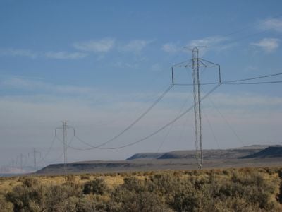
The Pacific DC Intertie is a high-voltage direct current transmission line stretching approximately 846 miles from northern Oregon to the Los Angeles area. It runs through Nevada and California, carrying electrical power at a capacity of about 3100 megawatts.

President John F. Kennedy approved this transmission project in 1961, and the line first operated in 1970 after several years of construction. This created a direct connection to deliver electricity from the Pacific Northwest to California's growing population.

The transmission line represents a collaboration between American and Swedish engineering companies, demonstrating international technological partnership in energy infrastructure development.

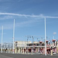
The line runs from Celilo Converter Station near The Dalles in Oregon to Sylmar Converter Station north of Los Angeles. Various viewpoints and information sites exist along the route, though most of the active infrastructure is not open to the public for safety reasons.

The system transports electricity generated from Columbia River hydroelectric dams, allowing Los Angeles to access significantly cheaper power. This long-distance connection has proven to be one of the most economical ways to deliver affordable energy across such a vast region.

The community of curious travelers

AroundUs brings together thousands of curated places, local tips, and hidden gems, enriched daily by 60,000 contributors worldwide.

Start exploring
Location
Location
Location
Inception
1970
GPS coordinates
45.59417,-121.11417
Latest update
December 7, 2025 10:08
Around this place
The Dalles Dam
United States of America

The Dalles Dam

2.6 km
Celilo Converter Station
United States of America

Celilo Converter Station

100 m
The Dalles Bridge
United States of America

The Dalles Bridge

2.6 km
The Dalles Mint
United States of America

The Dalles Mint

4.9 km
Pulpit Rock
United States of America

Pulpit Rock

5.8 km
Old St. Peter's Landmark
United States of America

Old St. Peter's Landmark

5.8 km
Granada Theater
United States of America

Granada Theater

5.3 km
Rorick House Museum
United States of America

Rorick House Museum

6.2 km
Bennett–Williams House
United States of America

Bennett–Williams House

6.2 km
Dr. J. A. Reuter House
United States of America

Dr. J. A. Reuter House

5.4 km
Indian Shaker Church and Gulick Homestead
United States of America

Indian Shaker Church and Gulick Homestead

2 km
The Dalles Civic Auditorium
United States of America

The Dalles Civic Auditorium

5.3 km
Hugh Glenn House
United States of America

Hugh Glenn House

5.8 km
Original Wasco County Courthouse
United States of America

Original Wasco County Courthouse

5.9 km
The Dalles Carnegie Library
United States of America

The Dalles Carnegie Library

5.4 km
Joseph D. and Margaret Kelly House
United States of America

Joseph D. and Margaret Kelly House

5 km
U.S. Post Office
United States of America

U.S. Post Office

5.6 km
Edward French House
United States of America

Edward French House

5.7 km
John and Murta Van Dellen House
United States of America

John and Murta Van Dellen House

5.5 km
Heimrich–Seufert House
United States of America

Heimrich–Seufert House

5.5 km
John L. Thompson House
United States of America

John L. Thompson House

5.7 km
Sharp Family Residential Ensemble
United States of America

Sharp Family Residential Ensemble

5.2 km
Fulton–Taylor House
United States of America

Fulton–Taylor House

5.5 km
Orlando Humason House
United States of America

Orlando Humason House

5.7 km
National Neon Sign Museum
United States of America

National Neon Sign Museum

5.5 km
Sunshine Mill
United States of America

Sunshine Mill

4.5 km
Wonderworks Children’s Museum
United States of America

Wonderworks Children’s Museum

4.9 km
Mill Creek Bridge
United States of America

Mill Creek Bridge

6.3 km
Show the full map
« Pacific DC Intertie - High-voltage transmission line between Oregon and Los Angeles, United States » is provided by Around Us (aroundus.com). Images and texts are derived from Wikimedia project under a Creative Commons license. You are allowed to copy, distribute, and modify copies of this page, under the conditions set by the license, as long as this note is clearly visible.

Discover hidden gems everywhere you go!

From secret cafés to breathtaking viewpoints, skip the crowded tourist spots and find places that match your style. Our app makes it easy with voice search, smart filtering, route optimization, and insider tips from travelers worldwide. Download now for the complete mobile experience.

Around Us App Screenshot

A unique approach to discovering new places

Le Figaro

All the places worth exploring

France Info

A tailor-made excursion in just a few clicks

20 Minutes

Around Us
Travel Guide & Maps
Download

Send to your phone

QR Code
1

Open the camera app on your mobile.

2

Point at the QR code with your camera. A notification will appear.

3

Tap the notification to open the link.