Chest opened
+${chestReward.xp} XP
Explorer
NOUVEAU ×${chestReward.collectible.quantity}
tapez pour fermer
Chest locked

Open chests in the app

Around Us is built for your phone — chests unlock when you walk, explore and capture nearby places.

Enable Location

We need your location to show you interesting places around you

Discover nearby places

Find interesting locations and hidden gems around you

Precise directions

Get accurate directions and distances to places

Your location is never shared with other users. It's only used when you tap the location button.

Log in to your account

Start exploring — it's free

Trusted by 72,889 travelers worldwide

Continue with Google
Continue with Apple
or

We will send you a code to connect

By continuing, you accept our Terms and Conditions and our Privacy Policy

Check your inbox

We've sent a pincode in your inbox. Please enter the code below.

Franklin River
Discussion Reviews Photo
1.3k Popularity

Franklin River, Brook in Area A Bamfield, Canada

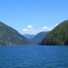
The Franklin River is a brook on Vancouver Island that flows west into Sproat Narrows of Alberni Inlet. Its waters connect to the coastal inlets of Barkley Sound.

The river was named in 1864 during the Vancouver Island Exploration Expedition after Selim Franklin, who served as Chairman of the Exploration Committee. This naming documents European exploration of the region during that period.

The Franklin River holds traditional significance to the Hupačasath First Nation, who refer to this waterway as ʔa-waa-čis in their native language. This name reflects a long connection between the people and the water.

The river offers several access points along its course where visitors can reach the water. Connecting paths lead to observation areas near the riverbank.

In 1938, this location became a milestone in British Columbia's environmental history when the first seedlings were planted in logged areas. The site marks the beginning of modern reforestation practices in the province.

The community of curious travelers

AroundUs brings together thousands of curated places, local tips, and hidden gems, enriched daily by 60,000 contributors worldwide.

Start exploring
Location
Area A (Bamfield)
GPS coordinates
49.10994,-124.73297
Latest update
December 14, 2025 18:15
Reviews
Share your experience

No review yet

Discussions
Start a discussion...

No discussion yet

« Franklin River - Brook in Area A Bamfield, Canada » is provided by Around Us (aroundus.com). Images and texts are derived from Wikimedia project under a Creative Commons license. You are allowed to copy, distribute, and modify copies of this page, under the conditions set by the license, as long as this note is clearly visible.

Discover hidden gems everywhere you go!

From secret cafés to breathtaking viewpoints, skip the crowded tourist spots and find places that match your style. Our app makes it easy with voice search, smart filtering, route optimization, and insider tips from travelers worldwide. Download now for the complete mobile experience.

Around Us App Screenshot

A unique approach to discovering new places

Le Figaro

All the places worth exploring

France Info

A tailor-made excursion in just a few clicks

20 Minutes

Around Us
Travel Guide & Maps
Download

Send to your phone

QR Code
1

Open the camera app on your mobile.

2

Point at the QR code with your camera. A notification will appear.

3

Tap the notification to open the link.