Discovery Island Marine Provincial Park, Nature reserve in Juan de Fuca Electoral Area, Canada
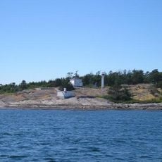
Discovery Island Marine Provincial Park covers 67 hectares on the southern half of Discovery Island, where the Strait of Juan de Fuca meets Haro Strait. The terrain is coastal Douglas fir and shore pine with an understory of bracken, snowberry and Oregon grape. Pandora Hill rises on the east side, topped by a lighthouse that cannot be entered.
The land was bought from the Crown in 1867 by George Jay and James Chestney Bales; Bales took sole possession in 1871 and sold it to William James Palmer in 1901, who passed it to Warburton Pike in 1912. After Pike's death in 1917 his bank sold the property to Captain Ernest Godfrey Beaumont, who had bought it in 1918 and left it to British Columbia in his will with the wish that it become a provincial park. The park was established in 1972.
The northern half of Discovery Island is a reserve of the Songhees First Nation, not part of the park. Long before settlers arrived, the island served as hunting and fishing grounds for various First Nations. The park itself covers only the southern half of the island.
The site is only reachable by boat, so you need to plan your trip from a mainland launching point. Keep in mind there is no drinking water on site and basic camping facilities are limited.
An automated lighthouse on Pandora Hill serves as a navigation marker for passing ships and sits at a point where the Canada-United States border runs across the water. This location makes it a key reference point for vessels traveling in the region.
The community of curious travelers
AroundUs brings together thousands of curated places, local tips, and hidden gems, enriched daily by 94,483 contributors worldwide.