Enable Location

We need your location to show you interesting places around you

Discover nearby places

Find interesting locations and hidden gems around you

Precise directions

Get accurate directions and distances to places

Your location is never shared with other users. It's only used when you tap the location button.

Princess Louisa Inlet

Log in to your account

Start exploring — it's free

Trusted by 63,417 travelers worldwide

Continue with Google
Continue with Apple
or

We will send you a code to connect

By continuing, you accept our Terms and Conditions and our Privacy Policy

Check your inbox

We've sent a pincode in your inbox. Please enter the code below.

Princess Louisa Inlet
Discussion Reviews 1 Photos 1 Collections
8.3k Popularity

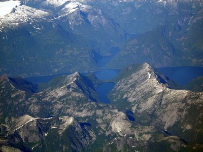
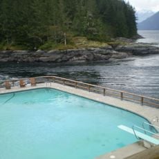
Princess Louisa Inlet, Marine inlet in British Columbia, Canada.

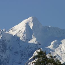
Princess Louisa Inlet is a marine arm in British Columbia that extends roughly six kilometers inland, bordered by steep granite cliffs that drop sharply into deep waters. Multiple waterfalls cascade directly into the sea at its northern reaches.

Captain George Richards conducted the first detailed survey of the inlet in 1860, mapping various geographical features along the British Columbia coastline. His charting work established how these waters and their features became known to Europeans and later visitors.

The inlet carries the name Swiwelat, rooted in the language of the Shíshálh Nation, whose people traditionally occupied this area and established settlements near its entrance. The landscape today reflects generations of Indigenous connection to these waters and shorelines.

The passage through Malibu Rapids at the inlet's entrance demands careful timing, as currents accelerate to roughly nine knots during spring tides through the narrow channel. Travelers should study tide schedules and local conditions before attempting the crossing.

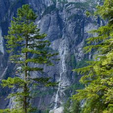
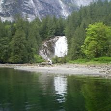
James Bruce Falls and Chatterbox Falls pour glacial meltwater into the inlet, with both cascades visible from boats throughout the year regardless of season. This constant cold-water source creates a dynamic visual backdrop that shifts with weather and light.

The community of curious travelers

AroundUs brings together thousands of curated places, local tips, and hidden gems, enriched daily by 60,000 contributors worldwide.

Start exploring
Location
Part of
Jervis Inlet
GPS coordinates
50.18330,-123.80000
Latest update
December 8, 2025 20:18
British Columbia: The list of the most impressive landscapes from the Pacific to the Rockies

British Columbia shows its natural sights from the Pacific coast to the rocky peaks, with hot springs, ancient forests, and stunning fjords to explore.

Reviews
Share your experience

No review yet

Discussions
Start a discussion...

No discussion yet

« Princess Louisa Inlet - Marine inlet in British Columbia, Canada » is provided by Around Us (aroundus.com). Images and texts are derived from Wikimedia project under a Creative Commons license. You are allowed to copy, distribute, and modify copies of this page, under the conditions set by the license, as long as this note is clearly visible.

Discover hidden gems everywhere you go!

From secret cafés to breathtaking viewpoints, skip the crowded tourist spots and find places that match your style. Our app makes it easy with voice search, smart filtering, route optimization, and insider tips from travelers worldwide. Download now for the complete mobile experience.

Around Us App Screenshot

A unique approach to discovering new places

Le Figaro

All the places worth exploring

France Info

A tailor-made excursion in just a few clicks

20 Minutes

Around Us
Travel Guide & Maps
Download

Send to your phone

QR Code
1

Open the camera app on your mobile.

2

Point at the QR code with your camera. A notification will appear.

3

Tap the notification to open the link.