Enable Location

We need your location to show you interesting places around you

Discover nearby places

Find interesting locations and hidden gems around you

Precise directions

Get accurate directions and distances to places

Your location is never shared with other users. It's only used when you tap the location button.

Tintic Standard Reduction Mill

Log in to your account

Start exploring — it's free

Trusted by 62,522 travelers worldwide

Continue with Google
Continue with Apple
or

We will send you a code to connect

By continuing, you accept our Terms and Conditions and our Privacy Policy

Check your inbox

We've sent a pincode in your inbox. Please enter the code below.

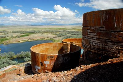
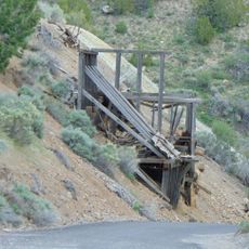
Tintic Standard Reduction Mill, abandoned refinery or concentrator on Warm Springs Mountain in Genola, Utah, United States

The Tintic Standard Reduction Mill is a historic industrial facility in Genola, Utah, built in the early 1920s to process ore from nearby mines. The structure features thick brick walls, large windows, and chimneys designed to handle large-scale metal processing operations.

The mill was built between 1919 and 1921 by the Tintic Standard Mining Company to process silver and other metals using a specialized process. It closed around 1925 when nearby mines no longer produced enough high-grade ore and shipping costs became less of a burden.

The site is visible from the road and allows visitors to walk around the ruins and view the industrial architecture. Simple paths run around the property, and visits work best during daylight to appreciate the structural details.

The mill used the Augustin process, a rare method in 1920s America that combined roasting ore with salt and strong brine solution for metal extraction. A small community called Harold was established nearby and named after Emil Raddatz's son, but it disappeared after the mill shut down.

The community of curious travelers

AroundUs brings together thousands of curated places, local tips, and hidden gems, enriched daily by 60,000 contributors worldwide.

Start exploring
Location
GPS coordinates
39.95720,-111.85300
Latest update
February 7, 2026 11:01
Around this place
Mount Nebo
United States of America

Mount Nebo

17 km
Sri Sri Radha Krishna Temple
United States of America

Sri Sri Radha Krishna Temple

21 km
Payson Utah Temple
United States of America

Payson Utah Temple

11.2 km
Mammoth
United States of America

Mammoth

23.4 km
Peteetneet Museum and Cultural Arts Center
United States of America

Peteetneet Museum and Cultural Arts Center

14.6 km
West Mountain
United States of America

West Mountain

14.9 km
Santaquin Junior High School
United States of America

Santaquin Junior High School

7 km
David H. Jones House
United States of America

David H. Jones House

24.2 km
Spanish Fork High School Gymnasium
United States of America

Spanish Fork High School Gymnasium

23.6 km
Payson Historic District
United States of America

Payson Historic District

14.1 km
Payson Presbyterian Church
United States of America

Payson Presbyterian Church

13.5 km
David Morgan House
United States of America

David Morgan House

4.2 km
Eureka LDS Church Meetinghouse
United States of America

Eureka LDS Church Meetinghouse

22.6 km
Ira W. Gardner House
United States of America

Ira W. Gardner House

18.9 km
John Dixon House
United States of America

John Dixon House

14.3 km
Christopher F. Dixon, Jr., House
United States of America

Christopher F. Dixon, Jr., House

14.4 km
Samuel Douglass House
United States of America

Samuel Douglass House

14.3 km
Eureka Lilly Headframe
United States of America

Eureka Lilly Headframe

18.4 km
Lincoln Beach
United States of America

Lincoln Beach

21.1 km
Huish Theater
United States of America

Huish Theater

14 km
Big Canyon
United States of America

Big Canyon

12.7 km
Mount Nebo Wilderness
United States of America

Mount Nebo Wilderness

15.9 km
Payson Canyon
United States of America

Payson Canyon

13.4 km
Homansville Canyon
United States of America

Homansville Canyon

18.1 km
Devils Kitchen (Juab County, Utah)
United States of America

Devils Kitchen (Juab County, Utah)

22.3 km
Big East Reservoir
United States of America

Big East Reservoir

18.3 km
McClellan Lake
United States of America

McClellan Lake

18 km
Eureka Historic District
United States of America

Eureka Historic District

22.5 km
Show the full map
« Tintic Standard Reduction Mill - abandoned refinery or concentrator on Warm Springs Mountain in Genola, Utah, United States » is provided by Around Us (aroundus.com). Images and texts are derived from Wikimedia project under a Creative Commons license. You are allowed to copy, distribute, and modify copies of this page, under the conditions set by the license, as long as this note is clearly visible.

Discover hidden gems everywhere you go!

From secret cafés to breathtaking viewpoints, skip the crowded tourist spots and find places that match your style. Our app makes it easy with voice search, smart filtering, route optimization, and insider tips from travelers worldwide. Download now for the complete mobile experience.

Around Us App Screenshot

A unique approach to discovering new places

Le Figaro

All the places worth exploring

France Info

A tailor-made excursion in just a few clicks

20 Minutes

Around Us
Travel Guide & Maps
Download

Send to your phone

QR Code
1

Open the camera app on your mobile.

2

Point at the QR code with your camera. A notification will appear.

3

Tap the notification to open the link.