Enable Location

We need your location to show you interesting places around you

Discover nearby places

Find interesting locations and hidden gems around you

Precise directions

Get accurate directions and distances to places

Your location is never shared with other users. It's only used when you tap the location button.

Menhir de la Tiemblais

Log in to your account

Start exploring — it's free

Trusted by 61,980 travelers worldwide

Continue with Google
Continue with Apple
or

We will send you a code to connect

By continuing, you accept our Terms and Conditions and our Privacy Policy

Check your inbox

We've sent a pincode in your inbox. Please enter the code below.

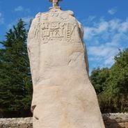
Menhir de la Tiemblais, Neolithic menhir in Saint-Samson-sur-Rance, France.

Menhir de la Tiemblais is a Neolithic granite monolith standing about 8.5 meters tall and weighing between 50 and 60 tons. Its surface features twelve carved panels displaying representations of axes, crosses, and small animal figures.

This stone emerged during prehistoric times and was officially classified as a protected historical monument in March 1977. The designation recognized its importance for understanding Neolithic carving techniques and early human expression.

Local people call this stone the "Bonde de l'Enfer," meaning the seal of hell's entrance, reflecting old beliefs about its supernatural role. The name still appears in regional stories and guides the way locals talk about their landscape.

The carved details on the surface become visible only under certain lighting angles, making early morning or late afternoon the best times to visit. Visiting during these hours allows the low sun to highlight the ancient patterns across the stone.

A white quartz vein runs through the granite structure, creating a natural striped pattern. The stone itself leans at a steep angle toward the east, giving it a distinctive tilted appearance despite its enormous weight.

The community of curious travelers

AroundUs brings together thousands of curated places, local tips, and hidden gems, enriched daily by 60,000 contributors worldwide.

Start exploring
GPS coordinates
48.49433,-2.01830
Latest update
December 6, 2025 17:47
France of standing stones: journey through menhirs, dolmens, and alignments

Throughout France, stone silhouettes still stand in fields, forests, or by the sea. They existed long before villages and roads, witnesses to a world that believed in the sky and hidden forces of the earth. These menhirs, erected over five thousand years ago, in their own way narrate the dawn of...

« Menhir de la Tiemblais - Neolithic menhir in Saint-Samson-sur-Rance, France » is provided by Around Us (aroundus.com). Images and texts are derived from Wikimedia project under a Creative Commons license. You are allowed to copy, distribute, and modify copies of this page, under the conditions set by the license, as long as this note is clearly visible.

Discover hidden gems everywhere you go!

From secret cafés to breathtaking viewpoints, skip the crowded tourist spots and find places that match your style. Our app makes it easy with voice search, smart filtering, route optimization, and insider tips from travelers worldwide. Download now for the complete mobile experience.

Around Us App Screenshot

A unique approach to discovering new places

Le Figaro

All the places worth exploring

France Info

A tailor-made excursion in just a few clicks

20 Minutes

Around Us
Travel Guide & Maps
Download

Send to your phone

QR Code
1

Open the camera app on your mobile.

2

Point at the QR code with your camera. A notification will appear.

3

Tap the notification to open the link.