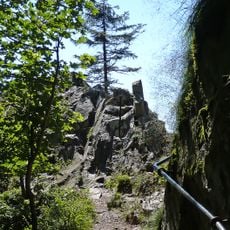
Blockhaus des Trois Fours, blockhaus à Stosswihr, France
Location: Stosswihr
Inception: 1915
GPS coordinates: 48.04991,7.02571
Latest update: November 20, 2025 09:31
Sentier des Roches
418 m
Jardin d'altitude du Haut Chitelet
1.1 km
Réserve naturelle nationale de Frankenthal-Missheimle
806 m
Martinswand
797 m
Chaume Charlemagne - Faignes Forie
1.1 km
Belvédère de la petite Fecht
1.1 km
Scenic viewpoint
373 m
Scenic viewpoint
588 m
Scenic viewpoint
964 m
Scenic viewpoint
170 m
Scenic viewpoint
809 m
Scenic viewpoint
1.2 km
Scenic viewpoint
1.3 km
Memorial, commemorative plaque
994 m
Jardin botanique du Haut-Chitelet
1.1 km
Scenic viewpoint
1.3 km
Wayside cross
1.2 km
Wayside cross
694 m
Memorial, commemorative plaque
994 m
Scenic viewpoint
1.2 km
Memorial, memorial stone
1.3 km
Wayside cross
782 m
Waterfall
956 m
Waterfall
978 m
Waterfall
1 km
Waterfall
359 m
Waterfall
967 m
Waterfall
990 mReviews
Visited this place? Tap the stars to rate it and share your experience / photos with the community! Try now! You can cancel it anytime.
Discover hidden gems everywhere you go!
From secret cafés to breathtaking viewpoints, skip the crowded tourist spots and find places that match your style. Our app makes it easy with voice search, smart filtering, route optimization, and insider tips from travelers worldwide. Download now for the complete mobile experience.

A unique approach to discovering new places❞
— Le Figaro
All the places worth exploring❞
— France Info
A tailor-made excursion in just a few clicks❞
— 20 Minutes