Chest opened
+${chestReward.xp} XP
Explorer
NOUVEAU ×${chestReward.collectible.quantity}
tapez pour fermer
Chest locked

Open chests in the app

Around Us is built for your phone — chests unlock when you walk, explore and capture nearby places.

Enable Location

We need your location to show you interesting places around you

Discover nearby places

Find interesting locations and hidden gems around you

Precise directions

Get accurate directions and distances to places

Your location is never shared with other users. It's only used when you tap the location button.

Chama

Log in to your account

Start exploring — it's free

Trusted by 72,879 travelers worldwide

Continue with Google
Continue with Apple
or

We will send you a code to connect

By continuing, you accept our Terms and Conditions and our Privacy Policy

Check your inbox

We've sent a pincode in your inbox. Please enter the code below.

Discussion Reviews 2 Photos
27.1k Popularity

Chama, Mountain village in Rio Arriba County, New Mexico.

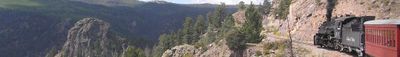
Chama is a mountain village in northern New Mexico near the Colorado border, situated at roughly 2400 meters elevation. The settlement spreads across the terrain and is surrounded by mountain ranges that define the landscape.

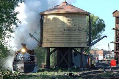
The village took shape in the late 1800s as a railroad junction when the Denver and Rio Grande Western Railroad began operations between Colorado and New Mexico. This rail connection was critical to the settlement's early growth and development.

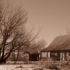
The community preserves Native American and Hispanic traditions through local crafts and seasonal festivals that continue throughout the year. These practices shape how the village looks and feels to visitors walking through its streets.

A car is necessary to reach the village and explore the surrounding forests, as public transportation is limited in this region. Driving your own vehicle gives visitors flexibility to explore the area at their own pace.

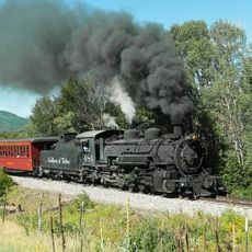
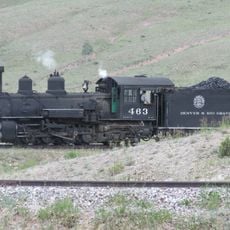
Steam locomotives of the Cumbres & Toltec Railroad depart from the Chama station to travel through mountain passes and cross the state border at high altitude. This historic railway is one of the few remaining coal-fired steam operations in North America.

The community of curious travelers

AroundUs brings together thousands of curated places, local tips, and hidden gems, enriched daily by 60,000 contributors worldwide.

Start exploring
Elevation above the sea
2,399 m
GPS coordinates
36.89470,-106.58400
Latest update
December 20, 2025 14:11
Around this place
Cumbres and Toltec Scenic Railroad
United States of America

Cumbres and Toltec Scenic Railroad

593 m
D&RGW 463
United States of America

D&RGW 463

1.1 km
Samuel Sanchez House
United States of America

Samuel Sanchez House

14.5 km
United States of America

Manuelita Trujillo House

16.6 km
United States of America

Los Brazos Historic District

16.1 km
United States of America

Casados House

17.4 km
United States of America

San Joaquin Church

19.3 km
United States of America

Fernando Trujillo, Sr., House

17 km
Gilbert Martinez Barn
United States of America

Gilbert Martinez Barn

19.3 km
United States of America

Ramon Jaramillo House and Barn

18.5 km
United States of America

Teodoro Martinez House

19.1 km
Sanchez-March House
United States of America

Sanchez-March House

17.3 km
United States of America

El Barranco Community Ditch

13.3 km
United States of America

Parkview Community Ditch

18.7 km
United States of America

Tecolote Rim

17.8 km
United States of America

Burns-Kelly Store Historic Site

1 km
United States of America

George Becker House Bunk House and Barn Historic Site

18.4 km
United States of America

Dunham Log House Historic Site

1 km
United States of America

Blanton Log House Historic Site

18.4 km
United States of America

T D Buras Store Historic Site

18.4 km
United States of America

Casados House Historic Site

18.4 km
United States of America

Chama Jail House Historic Site

1 km
United States of America

Ramon Jaramillo House and Barn Historic Site

19.2 km
United States of America

Miguel Valdez Barn Historic Site

19.2 km
United States of America

Gilbert Martinez Barn Historic Site

18.4 km
United States of America

Northern New Mexico Welcome Center

1.3 km
United States of America

Scenic viewpoint

3.1 km
United States of America

CDT Chama Basin Overview

18 km
Show the full map
Reviews
Share your experience

No review yet

Discussions
Start a discussion...

No discussion yet

« Chama - Mountain village in Rio Arriba County, New Mexico » is provided by Around Us (aroundus.com). Images and texts are derived from Wikimedia project under a Creative Commons license. You are allowed to copy, distribute, and modify copies of this page, under the conditions set by the license, as long as this note is clearly visible.

Discover hidden gems everywhere you go!

From secret cafés to breathtaking viewpoints, skip the crowded tourist spots and find places that match your style. Our app makes it easy with voice search, smart filtering, route optimization, and insider tips from travelers worldwide. Download now for the complete mobile experience.

Around Us App Screenshot

A unique approach to discovering new places

Le Figaro

All the places worth exploring

France Info

A tailor-made excursion in just a few clicks

20 Minutes

Around Us
Travel Guide & Maps
Download

Send to your phone

QR Code
1

Open the camera app on your mobile.

2

Point at the QR code with your camera. A notification will appear.

3

Tap the notification to open the link.